Property Record
2112 River Rd, North Apollo, PA 15673
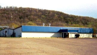

Property Detail
2112 River Rd
31-0-022313
MAP NO:221.16-01-11; 2.397A IMPRS
Storebuilding
Armstrong
BUSINESS
Pennsylvania
B and X Area of moderate flood hazard, usually the area between the limits of the 100-year and 500-year floods.
2.40 AC
2025
Armstrong County
2025
Pittsburgh
951500
Pittsburgh, PA
17,080 SF
NEARBY LISTINGS FOR SALE OR LEASE
DEMOGRAPHICS near 2112 River Rd
1 mile
3 mile
5 mile
2025 Total Population
5,651
17,153
27,517
2030 Population
5,640
16,956
27,161
Pop Growth 2025-2030
(0.19%)
(1.15%)
(1.29%)
Average Age
42
44
45
2025 Total Households
2,473
7,426
11,928
HH Growth 2025-2030
(0.28%)
(1.23%)
(1.35%)
Median Household Inc
$53,587
$58,637
$61,630
Avg Household Size
2.30
2.30
2.30
2025 Avg HH Vehicles
2.00
2.00
2.00
Median Home Value
$107,270
$132,800
$146,974
Median Year Built
1947
1951
1956
Nearby Places
Map Layers
Map Styles
 Street
 Aerial
Layers
 Traffic
 Biking
Places
Listings with unknown addresses are not visible on the map
- Restaurants
- Banks
- Shops
- Fitness
- Groceries
PUBLIC TRANSPORTATION
AIRPORT
Arnold Palmer Regional
Drive
Walk
Distance
Arnold Palmer Regional
54 min
30.7 mi
Freight Ports
Port of Baltimore
Drive
Walk
Distance
Port of Baltimore
292 min
244.3 mi
Nearby Properties
Address
Land Use
TOTAL SIZE
Lot Size
Zoning
Address
Land Use
TOTAL SIZE
Lot Size
Zoning
98.20 AC
Address
Land Use
TOTAL SIZE
Lot Size
Zoning
81,195 SF
7.65 AC
Address
Land Use
TOTAL SIZE
Lot Size
Zoning
39,556 SF
7.59 AC
Address
Land Use
TOTAL SIZE
Lot Size
Zoning
64.20 AC
Address
Land Use
TOTAL SIZE
Lot Size
Zoning
0.43 AC
Address
Land Use
TOTAL SIZE
Lot Size
Zoning
14.10 AC
Address
Land Use
TOTAL SIZE
Lot Size
Zoning
77,590 SF
10.53 AC
Address
Land Use
TOTAL SIZE
Lot Size
Zoning
1,680 SF
38.28 AC
Address
Land Use
TOTAL SIZE
Lot Size
Zoning
48,148 SF
5.27 AC
Address
Land Use
TOTAL SIZE
Lot Size
Zoning
23,088 SF
1.54 AC
RESIDENTIA
Address
Land Use
TOTAL SIZE
Lot Size
Zoning
9.07 AC
Address
Land Use
TOTAL SIZE
Lot Size
Zoning
140.40 AC
Address
Land Use
TOTAL SIZE
Lot Size
Zoning
69,000 SF
7.09 AC
Address
Land Use
TOTAL SIZE
Lot Size
Zoning
44,062 SF
1.14 AC
LIGHT INDU
Address
Land Use
TOTAL SIZE
Lot Size
Zoning
36,928 SF
37.75 AC
Address
Land Use
TOTAL SIZE
Lot Size
Zoning
Address
Land Use
TOTAL SIZE
Lot Size
Zoning
19,701 SF
0.37 AC
RESIDENTIA
Address
Land Use
TOTAL SIZE
Lot Size
Zoning
19,150 SF
6.26 AC
RESIDENTIA
Address
Land Use
TOTAL SIZE
Lot Size
Zoning
9.60 AC
Address
Land Use
TOTAL SIZE
Lot Size
Zoning
1,848 SF
5.32 AC
Address
Land Use
TOTAL SIZE
Lot Size
Zoning
28,600 SF
6.56 AC
Address
Land Use
TOTAL SIZE
Lot Size
Zoning
13,050 SF
Address
Land Use
TOTAL SIZE
Lot Size
Zoning
11,485 SF
2.42 AC
Address
Land Use
TOTAL SIZE
Lot Size
Zoning
Address
Land Use
TOTAL SIZE
Lot Size
Zoning
17,440 SF
2.57 AC
Address
Land Use
TOTAL SIZE
Lot Size
Zoning
17,225 SF
0.45 AC
BUSINESS
Address
Land Use
TOTAL SIZE
Lot Size
Zoning
16,419 SF
0.35 AC
BUSINESS
Address
Land Use
TOTAL SIZE
Lot Size
Zoning
25,456 SF
2.51 AC
Address
Land Use
TOTAL SIZE
Lot Size
Zoning
15.80 AC
Address
Land Use
TOTAL SIZE
Lot Size
Zoning
1,250 SF
3.97 AC
RESIDENTIA
The World's #1 Commercial Real Estate Marketplace
Connect with us
© 2026 CoStar Group
The information above has been obtained from sources believed reliable. While we do not doubt its accuracy we have not verified it and make no guarantee, warranty or representation about it. It is your responsibility to independently confirm its accuracy and completeness. Any projections, opinions, assumptions, or estimates used are for example only and do not represent the current or future performance of the property. The value of this transaction to you depends on tax and other factors which should be evaluated by your tax, financial, and legal advisors. You and your advisors should conduct a careful, independent investigation of the property to determine to your satisfaction the suitability of the property for your needs.