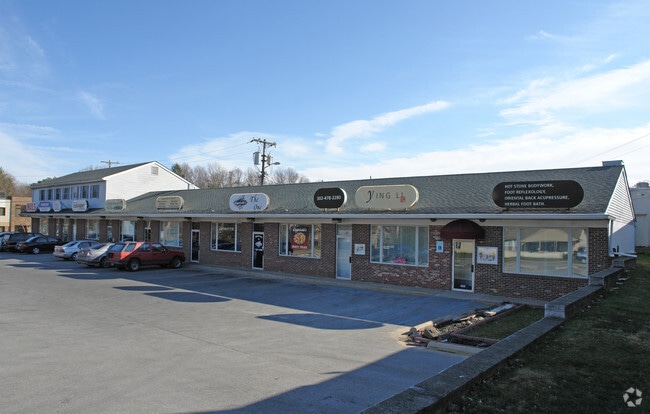
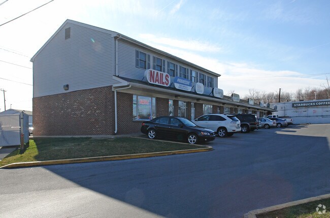
Property Record
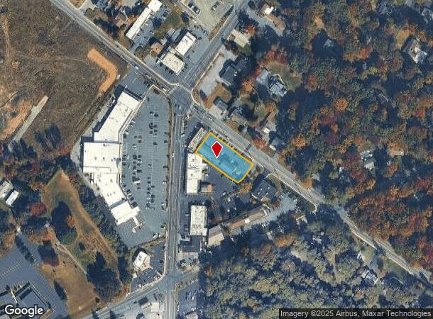
2112 Silverside Rd, Wilmington, DE 19810
NEARBY LISTINGS FOR SALE OR LEASE
Property Detail
2112 Silverside Rd
Philadelphia-Camden-Wilmington, PA-NJ-DE-MD
Silvercroft
06-068.00-030
L10 THRU 12 PT L9 .3053 AC
Regionalshoppingcenterormallwithanchorstore
New Castle
X
Delaware
10003C0067K
p9-12
2024
0.55 AC
2024
North New Castle County
011204
Philadelphia
5,400 SF
DEMOGRAPHICS near 2112 Silverside Rd
1 Mile
3 Mile
5 Mile
2024 Total Population
9,238
81,846
175,189
2029 Population
9,365
82,747
177,427
Pop Growth 2024-2029
+ 1.37%
+ 1.10%
+ 1.28%
Average Age
46
43
42
2024 Total Households
3,642
33,719
72,838
HH Growth 2024-2029
+ 1.46%
+ 1.14%
+ 1.39%
Median Household Inc
$113,109
$90,071
$73,800
Avg Household Size
2.50
2.40
2.30
2024 Avg HH Vehicles
2.00
2.00
2.00
Median Home Value
$368,234
$354,953
$328,663
Median Year Built
1958
1964
1961
Nearby Places
Map Layers
Map Styles
 Street
 Aerial
- Restaurants
- Banks
- Shops
- Fitness
- Groceries
PUBLIC TRANSPORTATION
COMMUTER RAIL
Claymont (R2 - Southeastern Pennsylvania Transportation Authority Regional Rail (SEPTA Regional Rail))
DRIVE
WALK
Distance
Claymont (R2 - Southeastern Pennsylvania Transportation Authority Regional Rail (SEPTA Regional Rail))
11 min
4.4 mi
DRIVE
WALK
Distance
9 min
4.4 mi
AIRPORT
Philadelphia International
DRIVE
WALK
Distance
Philadelphia International
28 min
16.5 mi
Freight Ports
Port of Wilmington, RI
DRIVE
WALK
Distance
Port of Wilmington, RI
16 min
7.8 mi
Nearby Properties
Address
Land Use
TOTAL SIZE
Lot Size
Zoning
Address
Land Use
TOTAL SIZE
Lot Size
Zoning
291,946 SF
21.27 AC
26R-2
Address
Land Use
TOTAL SIZE
Lot Size
Zoning
Address
Land Use
TOTAL SIZE
Lot Size
Zoning
596,916 SF
5.97 AC
OR
Address
Land Use
TOTAL SIZE
Lot Size
Zoning
696,387 SF
58.21 AC
OR
Address
Land Use
TOTAL SIZE
Lot Size
Zoning
371,733 SF
10.37 AC
OR
Address
Land Use
TOTAL SIZE
Lot Size
Zoning
15,880 SF
27.07 AC
Address
Land Use
TOTAL SIZE
Lot Size
Zoning
266,702 SF
20.04 AC
OR
Address
Land Use
TOTAL SIZE
Lot Size
Zoning
199,099 SF
49 AC
S
Address
Land Use
TOTAL SIZE
Lot Size
Zoning
109,145 SF
10.57 AC
S
Address
Land Use
TOTAL SIZE
Lot Size
Zoning
162,643 SF
30.61 AC
CR
Address
Land Use
TOTAL SIZE
Lot Size
Zoning
205,529 SF
42.34 AC
S
Address
Land Use
TOTAL SIZE
Lot Size
Zoning
96,745 SF
17.07 AC
S
Address
Land Use
TOTAL SIZE
Lot Size
Zoning
197,332 SF
12.13 AC
S
Address
Land Use
TOTAL SIZE
Lot Size
Zoning
122,819 SF
21.23 AC
S
Address
Land Use
TOTAL SIZE
Lot Size
Zoning
231,920 SF
23.52 AC
S
Address
Land Use
TOTAL SIZE
Lot Size
Zoning
380 SF
21.54 AC
S
Address
Land Use
TOTAL SIZE
Lot Size
Zoning
212,522 SF
16.04 AC
OR
Address
Land Use
TOTAL SIZE
Lot Size
Zoning
240,690 SF
18.44 AC
NCAP
Address
Land Use
TOTAL SIZE
Lot Size
Zoning
478,925 SF
59.10 AC
OR
Address
Land Use
TOTAL SIZE
Lot Size
Zoning
196,466 SF
11.50 AC
OR
Address
Land Use
TOTAL SIZE
Lot Size
Zoning
132,400 SF
7.79 AC
OR
Address
Land Use
TOTAL SIZE
Lot Size
Zoning
166,216 SF
5.01 AC
NCAP
Address
Land Use
TOTAL SIZE
Lot Size
Zoning
244,483 SF
10.01 AC
OR
Address
Land Use
TOTAL SIZE
Lot Size
Zoning
111,655 SF
50.62 AC
OR
Address
Land Use
TOTAL SIZE
Lot Size
Zoning
61,912 SF
31.94 AC
ST
Address
Land Use
TOTAL SIZE
Lot Size
Zoning
141,066 SF
36.52 AC
S
Address
Land Use
TOTAL SIZE
Lot Size
Zoning
43,332 SF
3.36 AC
CR
Address
Land Use
TOTAL SIZE
Lot Size
Zoning
148,870 SF
5.45 AC
OR
Address
Land Use
TOTAL SIZE
Lot Size
Zoning
124,677 SF
4.61 AC
CR
Address
Land Use
TOTAL SIZE
Lot Size
Zoning
180,096 SF
10.62 AC
ON
The World's #1 Commercial Real Estate Marketplace
Connect with us
© 2025 CoStar Group
The information above has been obtained from sources believed reliable. While we do not doubt its accuracy we have not verified it and make no guarantee, warranty or representation about it. It is your responsibility to independently confirm its accuracy and completeness. Any projections, opinions, assumptions, or estimates used are for example only and do not represent the current or future performance of the property. The value of this transaction to you depends on tax and other factors which should be evaluated by your tax, financial, and legal advisors. You and your advisors should conduct a careful, independent investigation of the property to determine to your satisfaction the suitability of the property for your needs.