Property Record
2113 Route 611, Swiftwater, PA 18370
NEARBY LISTINGS FOR SALE OR LEASE
-
-
View all Swiftwater listings for sale on LoopNet.com
Property Detail
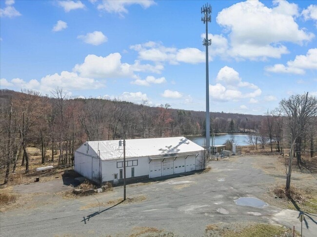
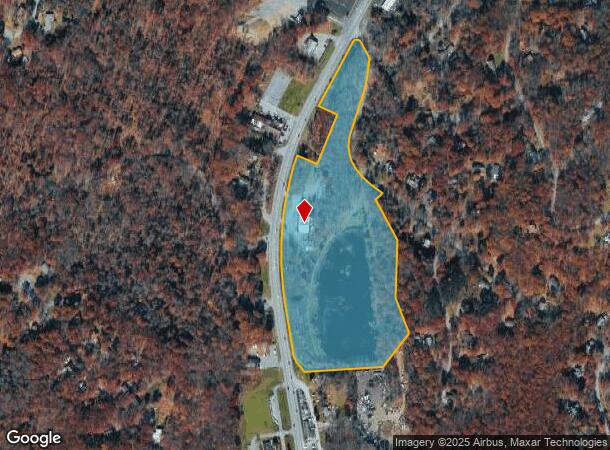
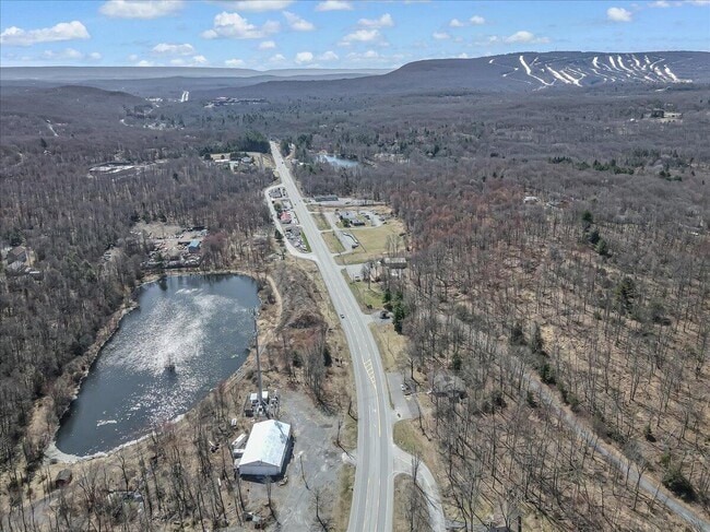
2113 Route 611
12.11.1.17-1
J T Butz
Warehouse
Monroe
A
Pennsylvania
42089C0254E
20.64 AC
2025
Monroe County
2025
Philadelphia
300401
East Stroudsburg, PA
6,180 SF
DEMOGRAPHICS near 2113 Route 611
1 Mile
3 Mile
5 Mile
2024 Total Population
942
6,324
22,333
2029 Population
898
6,326
22,164
Pop Growth 2024-2029
(4.67%)
+ 0.03%
(0.76%)
Average Age
46
45
44
2024 Total Households
394
2,559
8,583
HH Growth 2024-2029
(4.57%)
+ 0.12%
(0.75%)
Median Household Inc
$92,187
$102,124
$86,455
Avg Household Size
2.40
2.40
2.50
2024 Avg HH Vehicles
2.00
2.00
2.00
Median Home Value
$225,767
$223,184
$221,903
Median Year Built
1979
1979
1984
Nearby Places
Map Layers
Map Styles
 Street
 Aerial
- Restaurants
- Banks
- Shops
- Fitness
- Groceries
PUBLIC TRANSPORTATION
AIRPORT
Wilkes-Barre/Scranton International
DRIVE
WALK
Distance
Wilkes-Barre/Scranton International
52 min
39.5 mi
Lehigh Valley International
DRIVE
WALK
Distance
Lehigh Valley International
57 min
40.6 mi
Nearby Properties
Address
Land Use
TOTAL SIZE
Lot Size
Zoning
Address
Land Use
TOTAL SIZE
Lot Size
Zoning
463,854 SF
95.86 AC
C
Address
Land Use
TOTAL SIZE
Lot Size
Zoning
1,132 SF
212.87 AC
I
Address
Land Use
TOTAL SIZE
Lot Size
Zoning
627,114 SF
896.17 AC
R-2
Address
Land Use
TOTAL SIZE
Lot Size
Zoning
11,060 SF
156.57 AC
R-2
Address
Land Use
TOTAL SIZE
Lot Size
Zoning
64,000 SF
23.31 AC
C
Address
Land Use
TOTAL SIZE
Lot Size
Zoning
124,288 SF
10.58 AC
C
Address
Land Use
TOTAL SIZE
Lot Size
Zoning
133,288 SF
43.10 AC
R-2
Address
Land Use
TOTAL SIZE
Lot Size
Zoning
1,024 SF
147.49 AC
RD
Address
Land Use
TOTAL SIZE
Lot Size
Zoning
40,320 SF
17.79 AC
C
Address
Land Use
TOTAL SIZE
Lot Size
Zoning
6,164 SF
597.02 AC
RD
Address
Land Use
TOTAL SIZE
Lot Size
Zoning
9,450 SF
159 AC
R-1
Address
Land Use
TOTAL SIZE
Lot Size
Zoning
37,948 SF
47.53 AC
RR
Address
Land Use
TOTAL SIZE
Lot Size
Zoning
78,842 SF
7.24 AC
RD
Address
Land Use
TOTAL SIZE
Lot Size
Zoning
27,614 SF
36.14 AC
C
Address
Land Use
TOTAL SIZE
Lot Size
Zoning
5,952 SF
21.50 AC
C
Address
Land Use
TOTAL SIZE
Lot Size
Zoning
51,060 SF
7 AC
C
Address
Land Use
TOTAL SIZE
Lot Size
Zoning
4,696 SF
130.12 AC
B-1
Address
Land Use
TOTAL SIZE
Lot Size
Zoning
7,488 SF
5.74 AC
C
Address
Land Use
TOTAL SIZE
Lot Size
Zoning
1,212 SF
1 AC
C
Address
Land Use
TOTAL SIZE
Lot Size
Zoning
238.65 AC
R-3
Address
Land Use
TOTAL SIZE
Lot Size
Zoning
19,634 SF
10.20 AC
RC
Address
Land Use
TOTAL SIZE
Lot Size
Zoning
11,720 SF
0.10 AC
RD
Address
Land Use
TOTAL SIZE
Lot Size
Zoning
1,728 SF
127.62 AC
RD
Address
Land Use
TOTAL SIZE
Lot Size
Zoning
12,052 SF
4.20 AC
C
Address
Land Use
TOTAL SIZE
Lot Size
Zoning
12,945 SF
6.71 AC
C
Address
Land Use
TOTAL SIZE
Lot Size
Zoning
8,484 SF
0.10 AC
RD
Address
Land Use
TOTAL SIZE
Lot Size
Zoning
9,498 SF
1.72 AC
C
Address
Land Use
TOTAL SIZE
Lot Size
Zoning
1,800 SF
58.83 AC
RD
Address
Land Use
TOTAL SIZE
Lot Size
Zoning
8,940 SF
10.01 AC
C
The World's #1 Commercial Real Estate Marketplace
Connect with us
© 2025 CoStar Group
The information above has been obtained from sources believed reliable. While we do not doubt its accuracy we have not verified it and make no guarantee, warranty or representation about it. It is your responsibility to independently confirm its accuracy and completeness. Any projections, opinions, assumptions, or estimates used are for example only and do not represent the current or future performance of the property. The value of this transaction to you depends on tax and other factors which should be evaluated by your tax, financial, and legal advisors. You and your advisors should conduct a careful, independent investigation of the property to determine to your satisfaction the suitability of the property for your needs.