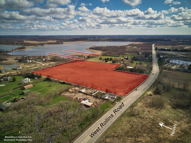
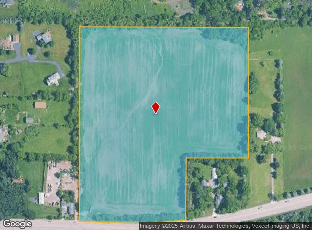
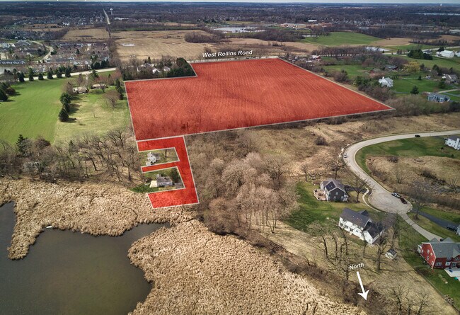
Property Record
21132 W Rollins Rd, Lake Villa, IL 60046
NEARBY LISTINGS FOR SALE OR LEASE
Property Detail
21132 W Rollins Rd
Chicago-Naperville-Elgin, IL-IN-WI
Pt Ne1/4 Ne1/4
06-15-200-026
PT NE1/4 NE1/4; PT LYG N OF ROLLINS ROAD OF PT DAFS: BEG SE COR NE1/4, W 44.5 RDS, N TO CEN LN HWY, WLY ALG CEN LN HWY T O PNT 58 RDS W OF E LN NE1/4, N TO N LN NE1/4, E ALG N LN TO
Farms
Lake
X
Illinois
17097C0043L
21.31 AC
2023
Far North
2024
Chicago
861202
DEMOGRAPHICS near 21132 W Rollins Rd
1 Mile
3 Mile
5 Mile
2024 Total Population
4,266
73,681
138,989
2029 Population
4,205
72,454
136,978
Pop Growth 2024-2029
(1.43%)
(1.67%)
(1.45%)
Average Age
41
38
39
2024 Total Households
1,535
24,893
48,648
HH Growth 2024-2029
(1.56%)
(1.80%)
(1.54%)
Median Household Inc
$98,389
$102,065
$97,534
Avg Household Size
2.80
2.90
2.80
2024 Avg HH Vehicles
2.00
2.00
2.00
Median Home Value
$226,638
$226,336
$237,490
Median Year Built
1993
1989
1990
Nearby Places
Map Layers
Map Styles
 Street
 Aerial
- Restaurants
- Banks
- Shops
- Fitness
- Groceries
PUBLIC TRANSPORTATION
COMMUTER RAIL
Round Lake Beach Station (North Central Service - Northeast Illinois Regional Commuter Railroad (Metra))
DRIVE
WALK
Distance
Round Lake Beach Station (North Central Service - Northeast Illinois Regional Commuter Railroad (Metra))
4 min
1.3 mi
Washington St (Grayslake) Station (Ncs) (North Central Service - Northeast Illinois Regional Commuter Railroad (Metra))
DRIVE
WALK
Distance
Washington St (Grayslake) Station (Ncs) (North Central Service - Northeast Illinois Regional Commuter Railroad (Metra))
7 min
3.6 mi
AIRPORT
Chicago O'Hare International
DRIVE
WALK
Distance
Chicago O'Hare International
48 min
36.6 mi
Freight Ports
Port Milwaukee
DRIVE
WALK
Distance
Port Milwaukee
62 min
51.2 mi
Nearby Properties
Address
Land Use
TOTAL SIZE
Lot Size
Zoning
Address
Land Use
TOTAL SIZE
Lot Size
Zoning
286,618 SF
11.81 AC
Address
Land Use
TOTAL SIZE
Lot Size
Zoning
5,303,058 SF
26.82 AC
Address
Land Use
TOTAL SIZE
Lot Size
Zoning
194,075 SF
14.84 AC
Address
Land Use
TOTAL SIZE
Lot Size
Zoning
1,407,234 SF
12.09 AC
Address
Land Use
TOTAL SIZE
Lot Size
Zoning
2,415,756 SF
12.61 AC
Address
Land Use
TOTAL SIZE
Lot Size
Zoning
190,034 SF
22.32 AC
Address
Land Use
TOTAL SIZE
Lot Size
Zoning
854,280 SF
18.40 AC
Address
Land Use
TOTAL SIZE
Lot Size
Zoning
Address
Land Use
TOTAL SIZE
Lot Size
Zoning
132,256 SF
18.59 AC
Address
Land Use
TOTAL SIZE
Lot Size
Zoning
129,483 SF
15.64 AC
Address
Land Use
TOTAL SIZE
Lot Size
Zoning
46,068 SF
0.65 AC
Address
Land Use
TOTAL SIZE
Lot Size
Zoning
200,944 SF
5.84 AC
Address
Land Use
TOTAL SIZE
Lot Size
Zoning
209,803 SF
3.88 AC
Address
Land Use
TOTAL SIZE
Lot Size
Zoning
421,146 SF
4.79 AC
Address
Land Use
TOTAL SIZE
Lot Size
Zoning
115,805 SF
4.38 AC
Address
Land Use
TOTAL SIZE
Lot Size
Zoning
17,484 SF
3.52 AC
Address
Land Use
TOTAL SIZE
Lot Size
Zoning
86,920 SF
6.89 AC
Address
Land Use
TOTAL SIZE
Lot Size
Zoning
50,540 SF
1.54 AC
Address
Land Use
TOTAL SIZE
Lot Size
Zoning
62,821 SF
6.79 AC
Address
Land Use
TOTAL SIZE
Lot Size
Zoning
104,143 SF
11.96 AC
Address
Land Use
TOTAL SIZE
Lot Size
Zoning
41,925 SF
5.15 AC
Address
Land Use
TOTAL SIZE
Lot Size
Zoning
224,750 SF
4.79 AC
Address
Land Use
TOTAL SIZE
Lot Size
Zoning
87,233 SF
7.72 AC
Address
Land Use
TOTAL SIZE
Lot Size
Zoning
43,777 SF
5.49 AC
Address
Land Use
TOTAL SIZE
Lot Size
Zoning
57,398 SF
5.23 AC
Address
Land Use
TOTAL SIZE
Lot Size
Zoning
285,750 SF
4.27 AC
Address
Land Use
TOTAL SIZE
Lot Size
Zoning
58,442 SF
3.70 AC
Address
Land Use
TOTAL SIZE
Lot Size
Zoning
10,998 SF
2.50 AC
Address
Land Use
TOTAL SIZE
Lot Size
Zoning
3.53 AC
Address
Land Use
TOTAL SIZE
Lot Size
Zoning
188,183 SF
17.16 AC
The World's #1 Commercial Real Estate Marketplace
Connect with us
© 2025 CoStar Group
The information above has been obtained from sources believed reliable. While we do not doubt its accuracy we have not verified it and make no guarantee, warranty or representation about it. It is your responsibility to independently confirm its accuracy and completeness. Any projections, opinions, assumptions, or estimates used are for example only and do not represent the current or future performance of the property. The value of this transaction to you depends on tax and other factors which should be evaluated by your tax, financial, and legal advisors. You and your advisors should conduct a careful, independent investigation of the property to determine to your satisfaction the suitability of the property for your needs.