Property Record
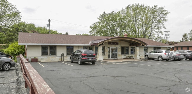
2114 N Sherman Ave, Madison, WI 53704


NEARBY LISTINGS FOR SALE OR LEASE
Property Detail
2114 N Sherman Ave
Madison, WI
Prospect Hill
0809-364-1010-1
PROSPECT HILL, BLK 1, LOT 18 & N 50 FT OF LOT 17.
Commercialnec
Dane
X
Wisconsin
55025C0426H
18,17
2024
0.37 AC
2024
Northeast Madison
002200
Milwaukee/Madison
3,520 SF
DEMOGRAPHICS near 2114 N Sherman Ave
1 mile
3 mile
5 mile
2024 Total Population
9,080
56,859
163,262
2029 Population
9,472
58,911
168,399
Pop Growth 2024-2029
+ 4.32%
+ 3.61%
+ 3.15%
Average Age
40
40
36
2024 Total Households
4,217
27,494
72,781
HH Growth 2024-2029
+ 4.39%
+ 3.70%
+ 3.41%
Median Household Inc
$58,301
$65,529
$60,506
Avg Household Size
2.10
2.00
2.00
2024 Avg HH Vehicles
2.00
2.00
1.00
Median Home Value
$234,919
$266,432
$292,985
Median Year Built
1965
1963
1972
Nearby Places
Map Layers
Map Styles
 Street
 Aerial
Transit
 Traffic
 Biking
Places
Listings with unknown addresses are not visible on the map
- Restaurants
- Banks
- Shops
- Fitness
- Groceries
PUBLIC TRANSPORTATION
AIRPORT
Dane County Regional/Truax Field
Drive
Walk
Distance
Dane County Regional/Truax Field
6 min
2.2 mi
SALE & LEASE HISTORY
LISTING DATE
SALE/LEASE

May 17, 2017
For Lease
Nearby Properties
Address
Land Use
TOTAL SIZE
Lot Size
Zoning
Address
Land Use
TOTAL SIZE
Lot Size
Zoning
509,946 SF
40.17 AC
IL
Address
Land Use
TOTAL SIZE
Lot Size
Zoning
461,454 SF
3.37 AC
CC-T
Address
Land Use
TOTAL SIZE
Lot Size
Zoning
251,632 SF
3.88 AC
TE
Address
Land Use
TOTAL SIZE
Lot Size
Zoning
289,884 SF
19.36 AC
SR-V2
Address
Land Use
TOTAL SIZE
Lot Size
Zoning
296,708 SF
1 AC
TE
Address
Land Use
TOTAL SIZE
Lot Size
Zoning
269,675 SF
2.25 AC
TR-U2
Address
Land Use
TOTAL SIZE
Lot Size
Zoning
211,457 SF
329.05 AC
PD
Address
Land Use
TOTAL SIZE
Lot Size
Zoning
216,017 SF
3.35 AC
TE
Address
Land Use
TOTAL SIZE
Lot Size
Zoning
197,046 SF
TE
Address
Land Use
TOTAL SIZE
Lot Size
Zoning
148,747 SF
0.83 AC
TE
Address
Land Use
TOTAL SIZE
Lot Size
Zoning
115,920 SF
2.38 AC
TE
Address
Land Use
TOTAL SIZE
Lot Size
Zoning
294,106 SF
29.06 AC
CC
Address
Land Use
TOTAL SIZE
Lot Size
Zoning
104,000 SF
11.21 AC
CC-T
Address
Land Use
TOTAL SIZE
Lot Size
Zoning
58,680 SF
6.29 AC
PD
Address
Land Use
TOTAL SIZE
Lot Size
Zoning
Address
Land Use
TOTAL SIZE
Lot Size
Zoning
92,130 SF
3.36 AC
PD
Address
Land Use
TOTAL SIZE
Lot Size
Zoning
105,743 SF
9.50 AC
IG
Address
Land Use
TOTAL SIZE
Lot Size
Zoning
37,133 SF
4.71 AC
CC-T
Address
Land Use
TOTAL SIZE
Lot Size
Zoning
101,080 SF
1.02 AC
CC-T
Address
Land Use
TOTAL SIZE
Lot Size
Zoning
13,335 SF
1 AC
TE
Address
Land Use
TOTAL SIZE
Lot Size
Zoning
68,016 SF
6.45 AC
PD
Address
Land Use
TOTAL SIZE
Lot Size
Zoning
121,013 SF
0.98 AC
TSS
Address
Land Use
TOTAL SIZE
Lot Size
Zoning
1.64 AC
CC-T
Address
Land Use
TOTAL SIZE
Lot Size
Zoning
55,295 SF
0.01 AC
TE
Address
Land Use
TOTAL SIZE
Lot Size
Zoning
77,504 SF
0.50 AC
TE
Address
Land Use
TOTAL SIZE
Lot Size
Zoning
58,817 SF
13.79 AC
SE
Address
Land Use
TOTAL SIZE
Lot Size
Zoning
86,935 SF
41.37 AC
PD
Address
Land Use
TOTAL SIZE
Lot Size
Zoning
68,064 SF
26.16 AC
TE
Address
Land Use
TOTAL SIZE
Lot Size
Zoning
78,300 SF
14.35 AC
CC
Address
Land Use
TOTAL SIZE
Lot Size
Zoning
48,970 SF
3.80 AC
PD
The World's #1 Commercial Real Estate Marketplace
Connect with us
© 2026 CoStar Group
The information above has been obtained from sources believed reliable. While we do not doubt its accuracy we have not verified it and make no guarantee, warranty or representation about it. It is your responsibility to independently confirm its accuracy and completeness. Any projections, opinions, assumptions, or estimates used are for example only and do not represent the current or future performance of the property. The value of this transaction to you depends on tax and other factors which should be evaluated by your tax, financial, and legal advisors. You and your advisors should conduct a careful, independent investigation of the property to determine to your satisfaction the suitability of the property for your needs.