Property Record
21143 E Rittenhouse Rd, Queen Creek, AZ 85142


Property Detail
21143 E Rittenhouse Rd
304-66-829
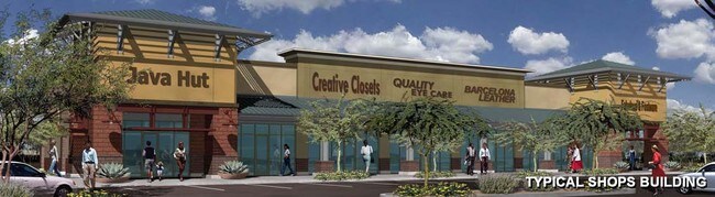
CORNERSTONE AT QUEEN CREEK MCR 883-13
Regionalshoppingcenterormallwithanchorstore
Maricopa
C-G
Arizona
C and X Area of minimal flood hazard, usually depicted on FIRMs as above the 500-year flood level.
5
2025
1.01 AC
2025
Queen Creek
817102
Phoenix
5,948 SF
Phoenix-Mesa-Chandler, AZ
NEARBY LISTINGS FOR SALE OR LEASE
DEMOGRAPHICS near 21143 E Rittenhouse Rd
1 mile
3 mile
5 mile
2025 Total Population
12,833
60,981
176,528
2030 Population
13,634
66,174
196,789
Pop Growth 2025-2030
+ 6.24%
+ 8.52%
+ 11.48%
Average Age
35
36
37
2025 Total Households
3,867
17,722
54,264
HH Growth 2025-2030
+ 6.15%
+ 8.60%
+ 11.56%
Median Household Inc
$123,944
$141,963
$119,905
Avg Household Size
3.30
3.40
3.20
2025 Avg HH Vehicles
2.00
2.00
2.00
Median Home Value
$518,100
$675,086
$577,092
Median Year Built
2008
2010
2010
Nearby Places
Map Layers
Map Styles
 Street
 Aerial
Layers
 Traffic
 Biking
Places
Listings with unknown addresses are not visible on the map
- Restaurants
- Banks
- Shops
- Fitness
- Groceries
PUBLIC TRANSPORTATION
AIRPORT
Phoenix Sky Harbor International
Drive
Walk
Distance
Phoenix Sky Harbor International
34 min
34.7 mi
Nearby Properties
Address
Land Use
TOTAL SIZE
Lot Size
Zoning
Address
Land Use
TOTAL SIZE
Lot Size
Zoning
64.72 AC
LI
Address
Land Use
TOTAL SIZE
Lot Size
Zoning
1,200,340 SF
85.82 AC
Address
Land Use
TOTAL SIZE
Lot Size
Zoning
32,858 SF
13.76 AC
C-G
Address
Land Use
TOTAL SIZE
Lot Size
Zoning
53,995 SF
10.12 AC
Address
Land Use
TOTAL SIZE
Lot Size
Zoning
477,934 SF
24.18 AC
MU
Address
Land Use
TOTAL SIZE
Lot Size
Zoning
227,555 SF
53.44 AC
R-43
Address
Land Use
TOTAL SIZE
Lot Size
Zoning
21,010 SF
2.72 AC
I-1
Address
Land Use
TOTAL SIZE
Lot Size
Zoning
20,053 SF
3.86 AC
R-43
Address
Land Use
TOTAL SIZE
Lot Size
Zoning
463,567 SF
135.55 AC
I-2
Address
Land Use
TOTAL SIZE
Lot Size
Zoning
187,208 SF
34.75 AC
MDR
Address
Land Use
TOTAL SIZE
Lot Size
Zoning
269,550 SF
63.63 AC
Address
Land Use
TOTAL SIZE
Lot Size
Zoning
420,631 SF
23.19 AC
Address
Land Use
TOTAL SIZE
Lot Size
Zoning
121,297 SF
27.91 AC
Address
Land Use
TOTAL SIZE
Lot Size
Zoning
270,126 SF
12.65 AC
C-TC
Address
Land Use
TOTAL SIZE
Lot Size
Zoning
163,373 SF
16.44 AC
MDR
Address
Land Use
TOTAL SIZE
Lot Size
Zoning
127,184 SF
14.80 AC
R-43
Address
Land Use
TOTAL SIZE
Lot Size
Zoning
216,568 SF
22.18 AC
C-G
Address
Land Use
TOTAL SIZE
Lot Size
Zoning
89,669 SF
13.60 AC
C-G
Address
Land Use
TOTAL SIZE
Lot Size
Zoning
95,413 SF
11.30 AC
R-43
Address
Land Use
TOTAL SIZE
Lot Size
Zoning
269,500 SF
18.18 AC
Address
Land Use
TOTAL SIZE
Lot Size
Zoning
179,893 SF
15 AC
C-G
Address
Land Use
TOTAL SIZE
Lot Size
Zoning
112,277 SF
9.68 AC
C-TC
Address
Land Use
TOTAL SIZE
Lot Size
Zoning
101,394 SF
8.70 AC
MDR
Address
Land Use
TOTAL SIZE
Lot Size
Zoning
152,901 SF
19.45 AC
Address
Land Use
TOTAL SIZE
Lot Size
Zoning
69,001 SF
16.70 AC
DC
Address
Land Use
TOTAL SIZE
Lot Size
Zoning
119,569 SF
11.13 AC
C-G
Address
Land Use
TOTAL SIZE
Lot Size
Zoning
182,360 SF
10.52 AC
M-H
Address
Land Use
TOTAL SIZE
Lot Size
Zoning
125,933 SF
7.92 AC
C-G
Address
Land Use
TOTAL SIZE
Lot Size
Zoning
63,033 SF
11.33 AC
R-C
Address
Land Use
TOTAL SIZE
Lot Size
Zoning
88,719 SF
13.20 AC
C2
The World's #1 Commercial Real Estate Marketplace
Connect with us
© 2026 CoStar Group
The information above has been obtained from sources believed reliable. While we do not doubt its accuracy we have not verified it and make no guarantee, warranty or representation about it. It is your responsibility to independently confirm its accuracy and completeness. Any projections, opinions, assumptions, or estimates used are for example only and do not represent the current or future performance of the property. The value of this transaction to you depends on tax and other factors which should be evaluated by your tax, financial, and legal advisors. You and your advisors should conduct a careful, independent investigation of the property to determine to your satisfaction the suitability of the property for your needs.