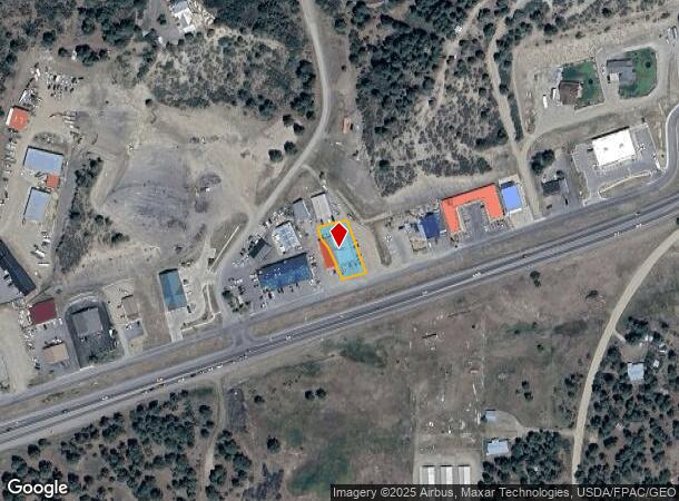
Property Record
2115 Eagle Dr, Pagosa Springs, CO 81147
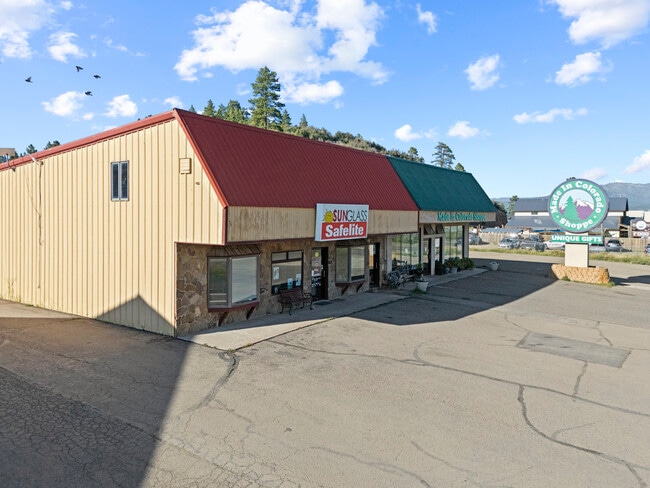

This Property Is For Sale
NEARBY LISTINGS FOR SALE OR LEASE
Property Detail
2115 Eagle Dr
569915105034
Piedra Estates
Storebuilding
SUBDIVISION: PIEDRA ESTATES TRACT: I POR PE SEC: 15 TWN: 35 RNG: 2W
X
Archuleta
08007C0270D
Colorado
2024
0.24 AC
2024
Colorado Southwest Area
974400
Other Market Areas
1,696 SF
DEMOGRAPHICS near 2115 Eagle Dr
1 Mile
3 Mile
5 Mile
2024 Total Population
688
5,933
9,048
2029 Population
787
6,783
10,276
Pop Growth 2024-2029
+ 14.39%
+ 14.33%
+ 13.57%
Average Age
46
46
46
2024 Total Households
306
2,631
3,919
HH Growth 2024-2029
+ 14.71%
+ 14.67%
+ 13.88%
Median Household Inc
$48,749
$57,535
$61,743
Avg Household Size
2.20
2.20
2.30
2024 Avg HH Vehicles
2.00
2.00
2.00
Median Home Value
$546,875
$434,424
$424,681
Median Year Built
1992
1993
1994
Nearby Places
Map Layers
Map Styles
 Street
 Aerial
- Restaurants
- Banks
- Shops
- Fitness
- Groceries
Nearby Properties
Address
Land Use
TOTAL SIZE
Lot Size
Zoning
Address
Land Use
TOTAL SIZE
Lot Size
Zoning
PUBLIC/QUA
Address
Land Use
TOTAL SIZE
Lot Size
Zoning
PUBLIC/QUA
Address
Land Use
TOTAL SIZE
Lot Size
Zoning
35,811 SF
3 AC
MIXED-USE
Address
Land Use
TOTAL SIZE
Lot Size
Zoning
26.50 AC
OPEN SPACE
Address
Land Use
TOTAL SIZE
Lot Size
Zoning
47,570 SF
6.97 AC
PUBLIC/QUA
Address
Land Use
TOTAL SIZE
Lot Size
Zoning
38,414 SF
13.63 AC
MIXED-USE
Address
Land Use
TOTAL SIZE
Lot Size
Zoning
8,155 SF
3 AC
MIXED-USE
Address
Land Use
TOTAL SIZE
Lot Size
Zoning
15,960 SF
362.64 AC
INDUSTRIAL
Address
Land Use
TOTAL SIZE
Lot Size
Zoning
32.48 AC
OPEN SPACE
Address
Land Use
TOTAL SIZE
Lot Size
Zoning
Address
Land Use
TOTAL SIZE
Lot Size
Zoning
3,480 SF
15.53 AC
OPEN SPACE
Address
Land Use
TOTAL SIZE
Lot Size
Zoning
11,010 SF
14.53 AC
PUBLIC/QUA
Address
Land Use
TOTAL SIZE
Lot Size
Zoning
2,690 SF
4.98 AC
MIXED-USE
Address
Land Use
TOTAL SIZE
Lot Size
Zoning
10.61 AC
MIXED-USE
Address
Land Use
TOTAL SIZE
Lot Size
Zoning
PUBLIC/QUA
Address
Land Use
TOTAL SIZE
Lot Size
Zoning
3,316 SF
1.21 AC
MIXED-USE
Address
Land Use
TOTAL SIZE
Lot Size
Zoning
2.62 AC
COMMERCIAL
Address
Land Use
TOTAL SIZE
Lot Size
Zoning
2,176 SF
38.13 AC
AGRICULTUR
Address
Land Use
TOTAL SIZE
Lot Size
Zoning
15,857 SF
0.63 AC
MIXED-USE
Address
Land Use
TOTAL SIZE
Lot Size
Zoning
6,748 SF
1.66 AC
MIXED-USE
Address
Land Use
TOTAL SIZE
Lot Size
Zoning
MIXED-USE
Address
Land Use
TOTAL SIZE
Lot Size
Zoning
420 SF
2.07 AC
OPEN SPACE
Address
Land Use
TOTAL SIZE
Lot Size
Zoning
27,645 SF
5.03 AC
MIXED-USE
Address
Land Use
TOTAL SIZE
Lot Size
Zoning
5,729 SF
2.25 AC
COMMERCIAL
Address
Land Use
TOTAL SIZE
Lot Size
Zoning
1,696 SF
140.66 AC
AGRICULTUR
Address
Land Use
TOTAL SIZE
Lot Size
Zoning
13,862 SF
0.74 AC
PUBLIC/QUA
Address
Land Use
TOTAL SIZE
Lot Size
Zoning
19,764 SF
2.16 AC
PLANNED UN
Address
Land Use
TOTAL SIZE
Lot Size
Zoning
8,228 SF
3.29 AC
PUBLIC/QUA
Address
Land Use
TOTAL SIZE
Lot Size
Zoning
65,245 SF
15.02 AC
PUBLIC/QUA
Address
Land Use
TOTAL SIZE
Lot Size
Zoning
PUBLIC/QUA
The World's #1 Commercial Real Estate Marketplace
Connect with us
© 2026 CoStar Group
The information above has been obtained from sources believed reliable. While we do not doubt its accuracy we have not verified it and make no guarantee, warranty or representation about it. It is your responsibility to independently confirm its accuracy and completeness. Any projections, opinions, assumptions, or estimates used are for example only and do not represent the current or future performance of the property. The value of this transaction to you depends on tax and other factors which should be evaluated by your tax, financial, and legal advisors. You and your advisors should conduct a careful, independent investigation of the property to determine to your satisfaction the suitability of the property for your needs.