Property Record
2115 Highway 98 E, Mccomb, MS 39648
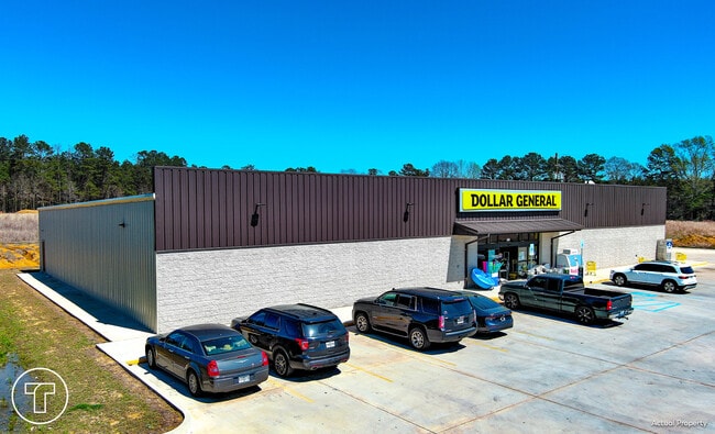

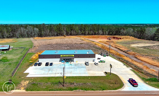
Property Detail
2115 Highway 98 E
McComb, MS
PT IN SE1/4 SE1/4 LY N OF HWY ZN:X-28113C0125C
811761DA
PIKE
Storebuilding
Mississippi
2025
2.50 AC
2025
Hattiesburg/South Area
950103
Other Market Areas
11,027 SF
NEARBY LISTINGS FOR SALE OR LEASE
-
-
View all Mccomb listings for sale on LoopNet.com
DEMOGRAPHICS near 2115 Highway 98 E
1 mile
3 mile
5 mile
2025 Total Population
457
8,434
19,994
2030 Population
437
8,194
19,429
Pop Growth 2025-2030
(4.38%)
(2.85%)
(2.83%)
Average Age
38
38
39
2025 Total Households
174
3,247
7,995
HH Growth 2025-2030
(4.60%)
(2.80%)
(2.80%)
Median Household Inc
$32,749
$40,376
$41,574
Avg Household Size
2.60
2.50
2.40
2025 Avg HH Vehicles
2.00
2.00
2.00
Median Home Value
$148,245
$127,164
$120,693
Median Year Built
1980
1978
1979
Nearby Places
Map Layers
Map Styles
 Street
 Aerial
Transit
 Traffic
 Biking
Places
Listings with unknown addresses are not visible on the map
- Restaurants
- Banks
- Shops
- Fitness
- Groceries
PUBLIC TRANSPORTATION
COMMUTER RAIL
Mccomb (City of New Orleans - Amtrak)
Drive
Walk
Distance
Mccomb (City of New Orleans - Amtrak)
5 min
3.8 mi
Freight Ports
Port of Greater Baton Rouge
Drive
Walk
Distance
Port of Greater Baton Rouge
116 min
102.0 mi
SALE & LEASE HISTORY
LISTING DATE
SALE/LEASE

Mar 28, 2025
For Sale
Nearby Properties
Address
Land Use
TOTAL SIZE
Lot Size
Zoning
Address
Land Use
TOTAL SIZE
Lot Size
Zoning
32,401 SF
6.42 AC
C2
Address
Land Use
TOTAL SIZE
Lot Size
Zoning
60,090 SF
19.40 AC
Address
Land Use
TOTAL SIZE
Lot Size
Zoning
1,447 SF
6.17 AC
RPL
Address
Land Use
TOTAL SIZE
Lot Size
Zoning
4,721 SF
2.71 AC
Address
Land Use
TOTAL SIZE
Lot Size
Zoning
110,395 SF
2.48 AC
SCD
Address
Land Use
TOTAL SIZE
Lot Size
Zoning
17,512 SF
1.33 AC
SCD
Address
Land Use
TOTAL SIZE
Lot Size
Zoning
7,680 SF
0.99 AC
Address
Land Use
TOTAL SIZE
Lot Size
Zoning
28,287 SF
Address
Land Use
TOTAL SIZE
Lot Size
Zoning
9,508 SF
0.96 AC
SCD
Address
Land Use
TOTAL SIZE
Lot Size
Zoning
68,193 SF
16.50 AC
Address
Land Use
TOTAL SIZE
Lot Size
Zoning
8,639 SF
1.11 AC
C2
Address
Land Use
TOTAL SIZE
Lot Size
Zoning
41,218 SF
4.32 AC
C2
Address
Land Use
TOTAL SIZE
Lot Size
Zoning
45,174 SF
3 AC
R60
Address
Land Use
TOTAL SIZE
Lot Size
Zoning
7,519 SF
0.52 AC
SCD
Address
Land Use
TOTAL SIZE
Lot Size
Zoning
8,180 SF
0.65 AC
SCD
Address
Land Use
TOTAL SIZE
Lot Size
Zoning
6,047 SF
0.55 AC
Address
Land Use
TOTAL SIZE
Lot Size
Zoning
4,005 SF
1.18 AC
Address
Land Use
TOTAL SIZE
Lot Size
Zoning
11,418 SF
3.53 AC
SCD
Address
Land Use
TOTAL SIZE
Lot Size
Zoning
4,187 SF
0.66 AC
RPL
Address
Land Use
TOTAL SIZE
Lot Size
Zoning
7,680 SF
0.14 AC
SCD
Address
Land Use
TOTAL SIZE
Lot Size
Zoning
62,878 SF
4.59 AC
Address
Land Use
TOTAL SIZE
Lot Size
Zoning
3,701 SF
0.32 AC
SCD
Address
Land Use
TOTAL SIZE
Lot Size
Zoning
5,353 SF
0.31 AC
Address
Land Use
TOTAL SIZE
Lot Size
Zoning
2,802 SF
8.20 AC
Address
Land Use
TOTAL SIZE
Lot Size
Zoning
51,456 SF
1.67 AC
C2
Address
Land Use
TOTAL SIZE
Lot Size
Zoning
14,258 SF
0.22 AC
SCD
Address
Land Use
TOTAL SIZE
Lot Size
Zoning
5,728 SF
3 AC
C2
Address
Land Use
TOTAL SIZE
Lot Size
Zoning
4,246 SF
2.53 AC
SCD
Address
Land Use
TOTAL SIZE
Lot Size
Zoning
5,432 SF
25 AC
Address
Land Use
TOTAL SIZE
Lot Size
Zoning
14,573 SF
0.27 AC
SCD
The World's #1 Commercial Real Estate Marketplace
Connect with us
© 2026 CoStar Group
The information above has been obtained from sources believed reliable. While we do not doubt its accuracy we have not verified it and make no guarantee, warranty or representation about it. It is your responsibility to independently confirm its accuracy and completeness. Any projections, opinions, assumptions, or estimates used are for example only and do not represent the current or future performance of the property. The value of this transaction to you depends on tax and other factors which should be evaluated by your tax, financial, and legal advisors. You and your advisors should conduct a careful, independent investigation of the property to determine to your satisfaction the suitability of the property for your needs.