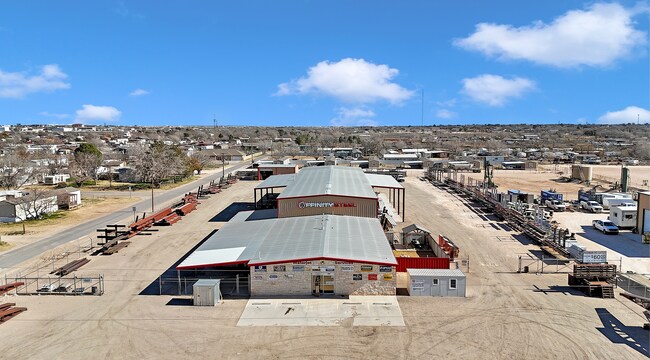
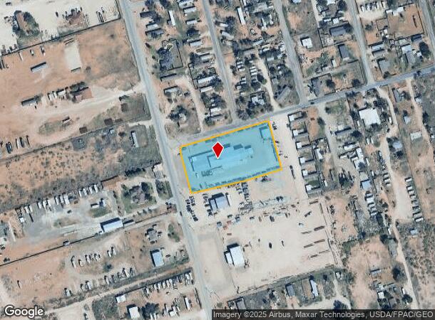
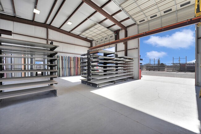
Property Record
2115 W County Road 117, Midland, TX 79706
NEARBY LISTINGS FOR SALE OR LEASE
Property Detail
2115 W County Road 117
Other Market Areas
B. Adams Addition
Midland, TX
ACRES: 2.316 BLK: 001 LOT: 001 ADDN: B. ADAMS ADDITION
0012500.001.0010
Midland
Officebuilding
Texas
2025
1
2025
2.31 AC
010127
Midland & Odessa
DEMOGRAPHICS near 2115 W County Road 117
1 Mile
3 Mile
5 Mile
2024 Total Population
2,367
28,907
85,084
2029 Population
2,392
29,402
87,090
Pop Growth 2024-2029
+ 1.06%
+ 1.71%
+ 2.36%
Average Age
35
34
35
2024 Total Households
761
9,382
29,687
HH Growth 2024-2029
+ 1.31%
+ 2.01%
+ 2.70%
Median Household Inc
$47,500
$58,554
$68,581
Avg Household Size
3.10
2.90
2.80
2024 Avg HH Vehicles
2.00
2.00
2.00
Median Home Value
$221,681
$184,365
$235,560
Median Year Built
1980
1977
1974
Nearby Places
Map Layers
Map Styles
 Street
 Aerial
- Restaurants
- Banks
- Shops
- Fitness
- Groceries
PUBLIC TRANSPORTATION
AIRPORT
Midland International Air And Space Port
DRIVE
WALK
Distance
Midland International Air And Space Port
21 min
13.6 mi
Freight Ports
Calhoun Port
DRIVE
WALK
Distance
Calhoun Port
526 min
472.6 mi
SALE & LEASE HISTORY
LISTING DATE
SALE/LEASE

Jan 19, 2024
For Lease
Feb 08, 2024
For Sale
Nearby Properties
Address
Land Use
TOTAL SIZE
Lot Size
Zoning
Address
Land Use
TOTAL SIZE
Lot Size
Zoning
15,052 SF
4.68 AC
C1
Address
Land Use
TOTAL SIZE
Lot Size
Zoning
245,203 SF
18.40 AC
Address
Land Use
TOTAL SIZE
Lot Size
Zoning
29,645 SF
2.07 AC
C1
Address
Land Use
TOTAL SIZE
Lot Size
Zoning
10,228 SF
15.98 AC
Address
Land Use
TOTAL SIZE
Lot Size
Zoning
46,512 SF
0.96 AC
C1
Address
Land Use
TOTAL SIZE
Lot Size
Zoning
41,790 SF
1.50 AC
C1
Address
Land Use
TOTAL SIZE
Lot Size
Zoning
12.91 AC
Address
Land Use
TOTAL SIZE
Lot Size
Zoning
800 SF
75.53 AC
Address
Land Use
TOTAL SIZE
Lot Size
Zoning
276 SF
0.48 AC
C1
Address
Land Use
TOTAL SIZE
Lot Size
Zoning
97,700 SF
10.79 AC
Address
Land Use
TOTAL SIZE
Lot Size
Zoning
26,390 SF
1.01 AC
C1
Address
Land Use
TOTAL SIZE
Lot Size
Zoning
86,922 SF
1.87 AC
PDMC
Address
Land Use
TOTAL SIZE
Lot Size
Zoning
6,510 SF
0.48 AC
C1
Address
Land Use
TOTAL SIZE
Lot Size
Zoning
218,900 SF
0.40 AC
C1
Address
Land Use
TOTAL SIZE
Lot Size
Zoning
9,650 SF
13 AC
MF1
Address
Land Use
TOTAL SIZE
Lot Size
Zoning
215,322 SF
19.80 AC
PDSC
Address
Land Use
TOTAL SIZE
Lot Size
Zoning
3,399 SF
648 AC
Address
Land Use
TOTAL SIZE
Lot Size
Zoning
103,500 SF
0.20 AC
C1
Address
Land Use
TOTAL SIZE
Lot Size
Zoning
15,068 SF
2.77 AC
LR2
Address
Land Use
TOTAL SIZE
Lot Size
Zoning
720 SF
1.86 AC
Address
Land Use
TOTAL SIZE
Lot Size
Zoning
4,263 SF
8.01 AC
Address
Land Use
TOTAL SIZE
Lot Size
Zoning
17,022 SF
1.60 AC
Address
Land Use
TOTAL SIZE
Lot Size
Zoning
13,440 SF
53.69 AC
Address
Land Use
TOTAL SIZE
Lot Size
Zoning
4,900 SF
0.72 AC
C1
Address
Land Use
TOTAL SIZE
Lot Size
Zoning
136,482 SF
0.26 AC
C1
Address
Land Use
TOTAL SIZE
Lot Size
Zoning
80,500 SF
0.48 AC
C1
Address
Land Use
TOTAL SIZE
Lot Size
Zoning
26,000 SF
0.30 AC
C1
Address
Land Use
TOTAL SIZE
Lot Size
Zoning
3,300 SF
18.80 AC
LR2
Address
Land Use
TOTAL SIZE
Lot Size
Zoning
26,090 SF
3.27 AC
Address
Land Use
TOTAL SIZE
Lot Size
Zoning
28,593 SF
23.92 AC
PDMC
The World's #1 Commercial Real Estate Marketplace
Connect with us
© 2026 CoStar Group
The information above has been obtained from sources believed reliable. While we do not doubt its accuracy we have not verified it and make no guarantee, warranty or representation about it. It is your responsibility to independently confirm its accuracy and completeness. Any projections, opinions, assumptions, or estimates used are for example only and do not represent the current or future performance of the property. The value of this transaction to you depends on tax and other factors which should be evaluated by your tax, financial, and legal advisors. You and your advisors should conduct a careful, independent investigation of the property to determine to your satisfaction the suitability of the property for your needs.