Property Record
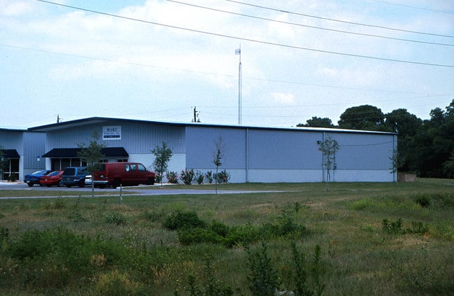
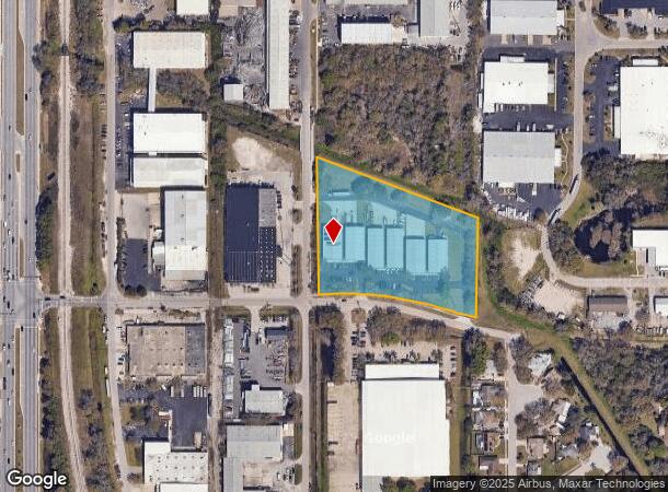
2101 47Th St, Sarasota, FL 34234
NEARBY LISTINGS FOR SALE OR LEASE
Property Detail
2101 47Th St
North Port-Sarasota-Bradenton, FL
47Th Street Industrial
0000-00-8186
47TH STREET INDUSTRIAL
Commercialacreage
Sarasota
AE
Florida
12115C0044G
4.18 AC
0
Sarasota
2024
Tampa/St Petersburg
001101
DEMOGRAPHICS near 2101 47Th St
1 Mile
3 Mile
5 Mile
2024 Total Population
5,374
68,253
159,533
2029 Population
6,155
78,599
183,680
Pop Growth 2024-2029
+ 14.53%
+ 15.16%
+ 15.14%
Average Age
45
45
47
2024 Total Households
2,404
30,842
71,078
HH Growth 2024-2029
+ 14.56%
+ 15.19%
+ 14.95%
Median Household Inc
$47,958
$62,352
$65,724
Avg Household Size
2.20
2.10
2.10
2024 Avg HH Vehicles
2.00
2.00
2.00
Median Home Value
$166,717
$291,883
$321,497
Median Year Built
1977
1983
1983
Nearby Places
- Restaurants
- Banks
- Shops
- Fitness
- Groceries
PUBLIC TRANSPORTATION
AIRPORT
Sarasota/Bradenton International
DRIVE
WALK
Distance
Sarasota/Bradenton International
8 min
3.5 mi
Freight Ports
Port Manatee
DRIVE
WALK
Distance
Port Manatee
33 min
20.9 mi
Nearby Properties
Address
Land Use
TOTAL SIZE
Lot Size
Zoning
Address
Land Use
TOTAL SIZE
Lot Size
Zoning
1,023,770 SF
76.55 AC
Address
Land Use
TOTAL SIZE
Lot Size
Zoning
124,840 SF
29.18 AC
G
Address
Land Use
TOTAL SIZE
Lot Size
Zoning
516,332 SF
7.62 AC
DTB
Address
Land Use
TOTAL SIZE
Lot Size
Zoning
439,798 SF
4.20 AC
DTC
Address
Land Use
TOTAL SIZE
Lot Size
Zoning
318,761 SF
143.53 AC
AA
Address
Land Use
TOTAL SIZE
Lot Size
Zoning
458,955 SF
3.99 AC
DTE
Address
Land Use
TOTAL SIZE
Lot Size
Zoning
252,425 SF
44.30 AC
G
Address
Land Use
TOTAL SIZE
Lot Size
Zoning
409,998 SF
1.09 AC
DTC
Address
Land Use
TOTAL SIZE
Lot Size
Zoning
394,304 SF
2.85 AC
DTE
Address
Land Use
TOTAL SIZE
Lot Size
Zoning
425,532 SF
3.05 AC
DTE
Address
Land Use
TOTAL SIZE
Lot Size
Zoning
284,102 SF
36.99 AC
G
Address
Land Use
TOTAL SIZE
Lot Size
Zoning
425,298 SF
25.59 AC
PD-R
Address
Land Use
TOTAL SIZE
Lot Size
Zoning
463,072 SF
2.21 AC
DTC
Address
Land Use
TOTAL SIZE
Lot Size
Zoning
223,241 SF
7.80 AC
DTE
Address
Land Use
TOTAL SIZE
Lot Size
Zoning
331,241 SF
44.24 AC
Address
Land Use
TOTAL SIZE
Lot Size
Zoning
150,740 SF
38.70 AC
MCI
Address
Land Use
TOTAL SIZE
Lot Size
Zoning
272,602 SF
28.35 AC
PD-R
Address
Land Use
TOTAL SIZE
Lot Size
Zoning
358,441 SF
31.80 AC
PD-R
Address
Land Use
TOTAL SIZE
Lot Size
Zoning
309,573 SF
7.06 AC
ORD
Address
Land Use
TOTAL SIZE
Lot Size
Zoning
1.70 AC
DTB
Address
Land Use
TOTAL SIZE
Lot Size
Zoning
258,407 SF
18.55 AC
RMF3
Address
Land Use
TOTAL SIZE
Lot Size
Zoning
199,653 SF
0.38 AC
DTC
Address
Land Use
TOTAL SIZE
Lot Size
Zoning
251,472 SF
11 AC
RSF2
Address
Land Use
TOTAL SIZE
Lot Size
Zoning
252,254 SF
0.98 AC
DTB
Address
Land Use
TOTAL SIZE
Lot Size
Zoning
321,015 SF
1.11 AC
DTB
Address
Land Use
TOTAL SIZE
Lot Size
Zoning
296,343 SF
26.53 AC
PD-R
Address
Land Use
TOTAL SIZE
Lot Size
Zoning
211,459 SF
2.36 AC
DTC
Address
Land Use
TOTAL SIZE
Lot Size
Zoning
19,464 SF
38.95 AC
G
Address
Land Use
TOTAL SIZE
Lot Size
Zoning
209,091 SF
21.30 AC
RMF3
Address
Land Use
TOTAL SIZE
Lot Size
Zoning
237,930 SF
1.58 AC
DTC
The World's #1 Commercial Real Estate Marketplace
Connect with us
© 2025 CoStar Group
The information above has been obtained from sources believed reliable. While we do not doubt its accuracy we have not verified it and make no guarantee, warranty or representation about it. It is your responsibility to independently confirm its accuracy and completeness. Any projections, opinions, assumptions, or estimates used are for example only and do not represent the current or future performance of the property. The value of this transaction to you depends on tax and other factors which should be evaluated by your tax, financial, and legal advisors. You and your advisors should conduct a careful, independent investigation of the property to determine to your satisfaction the suitability of the property for your needs.