Property Record
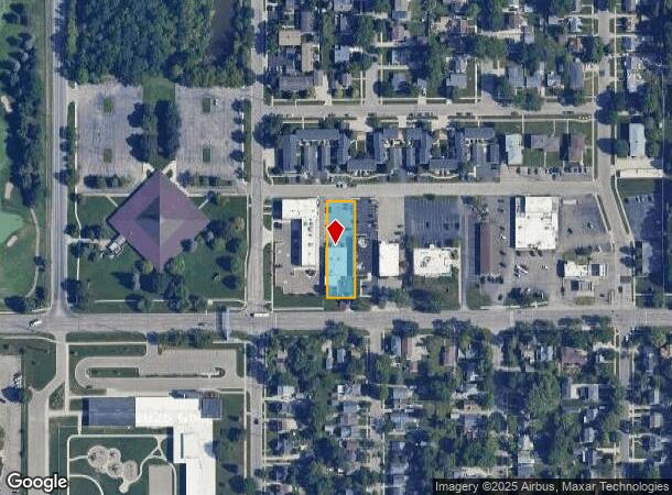
2117 E Grand River Ave, Lansing, MI 48912
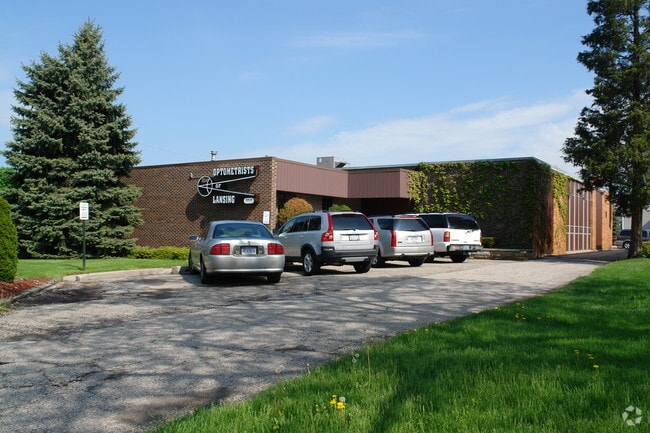
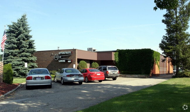
This Property Is For Sale
NEARBY LISTINGS FOR SALE OR LEASE
Property Detail
2117 E Grand River Ave
Lansing-East Lansing, MI
Hopwood Acres Subdivision
21-01-11-360-003
LOT 117 EXC. N. 20 FT. & W 11 FT. OF LOT 118 EXC. N 20 FT. HOPWOOD ACRES SUB. NO. 5
Officebuilding
Ingham
X
Michigan
26065C0132D
117-118
2024
0.41 AC
2025
Central Lansing
003103
West Michigan
5,023 SF
DEMOGRAPHICS near 2117 E Grand River Ave
1 Mile
3 Mile
5 Mile
2024 Total Population
14,357
93,326
167,421
2029 Population
14,350
93,931
167,861
Pop Growth 2024-2029
(0.05%)
+ 0.65%
+ 0.26%
Average Age
37
34
36
2024 Total Households
6,643
40,322
73,167
HH Growth 2024-2029
(0.18%)
+ 0.66%
+ 0.24%
Median Household Inc
$53,094
$42,615
$47,913
Avg Household Size
2.00
2.10
2.10
2024 Avg HH Vehicles
2.00
1.00
2.00
Median Home Value
$134,958
$134,832
$144,901
Median Year Built
1956
1962
1965
Nearby Places
- Restaurants
- Banks
- Shops
- Fitness
- Groceries
PUBLIC TRANSPORTATION
COMMUTER RAIL
East Lansing Amtrak Station (Blue Water - Amtrak)
DRIVE
WALK
Distance
East Lansing Amtrak Station (Blue Water - Amtrak)
7 min
3.1 mi
AIRPORT
Capital Region International
DRIVE
WALK
Distance
Capital Region International
10 min
5.0 mi
Freight Ports
Port of Toledo
DRIVE
WALK
Distance
Port of Toledo
145 min
114.3 mi
Nearby Properties
Address
Land Use
TOTAL SIZE
Lot Size
Zoning
Address
Land Use
TOTAL SIZE
Lot Size
Zoning
42,875 SF
35 AC
PD
Address
Land Use
TOTAL SIZE
Lot Size
Zoning
66,818 SF
0.99 AC
EV
Address
Land Use
TOTAL SIZE
Lot Size
Zoning
7,579 SF
83.53 AC
PD
Address
Land Use
TOTAL SIZE
Lot Size
Zoning
42,875 SF
28.77 AC
Address
Land Use
TOTAL SIZE
Lot Size
Zoning
111,180 SF
3.63 AC
G-1 BUS
Address
Land Use
TOTAL SIZE
Lot Size
Zoning
14,304 SF
3.37 AC
MIXED Z
Address
Land Use
TOTAL SIZE
Lot Size
Zoning
222,869 SF
0.10 AC
B3
Address
Land Use
TOTAL SIZE
Lot Size
Zoning
274,720 SF
10.55 AC
Address
Land Use
TOTAL SIZE
Lot Size
Zoning
73,179 SF
58.17 AC
RM14
Address
Land Use
TOTAL SIZE
Lot Size
Zoning
12,435 SF
0.52 AC
B3
Address
Land Use
TOTAL SIZE
Lot Size
Zoning
63,461 SF
32 AC
F COMM
Address
Land Use
TOTAL SIZE
Lot Size
Zoning
177,300 SF
8.72 AC
Address
Land Use
TOTAL SIZE
Lot Size
Zoning
69,851 SF
134.23 AC
I HVY
Address
Land Use
TOTAL SIZE
Lot Size
Zoning
13.13 AC
Address
Land Use
TOTAL SIZE
Lot Size
Zoning
66.43 AC
Address
Land Use
TOTAL SIZE
Lot Size
Zoning
16,466 SF
14.82 AC
DEVELOPMEN
Address
Land Use
TOTAL SIZE
Lot Size
Zoning
195,094 SF
1.89 AC
Address
Land Use
TOTAL SIZE
Lot Size
Zoning
2,137 SF
12.72 AC
H LT IN
Address
Land Use
TOTAL SIZE
Lot Size
Zoning
19,035 SF
12.32 AC
RM08
Address
Land Use
TOTAL SIZE
Lot Size
Zoning
20,438 SF
17.81 AC
DEVELOPMEN
Address
Land Use
TOTAL SIZE
Lot Size
Zoning
188,175 SF
4.37 AC
EV
Address
Land Use
TOTAL SIZE
Lot Size
Zoning
185,190 SF
0.41 AC
G-1 BUS
Address
Land Use
TOTAL SIZE
Lot Size
Zoning
300,760 SF
27.22 AC
RM08
Address
Land Use
TOTAL SIZE
Lot Size
Zoning
150,589 SF
3.06 AC
D-1 PRO
Address
Land Use
TOTAL SIZE
Lot Size
Zoning
183,047 SF
24.36 AC
B4
Address
Land Use
TOTAL SIZE
Lot Size
Zoning
131,234 SF
2.49 AC
Address
Land Use
TOTAL SIZE
Lot Size
Zoning
9,628 SF
1.86 AC
B2
Address
Land Use
TOTAL SIZE
Lot Size
Zoning
142,152 SF
47.56 AC
B4
Address
Land Use
TOTAL SIZE
Lot Size
Zoning
332,832 SF
2.48 AC
G-1 BUS
Address
Land Use
TOTAL SIZE
Lot Size
Zoning
51,248 SF
4.85 AC
I HVY
The World's #1 Commercial Real Estate Marketplace
Connect with us
© 2025 CoStar Group
The information above has been obtained from sources believed reliable. While we do not doubt its accuracy we have not verified it and make no guarantee, warranty or representation about it. It is your responsibility to independently confirm its accuracy and completeness. Any projections, opinions, assumptions, or estimates used are for example only and do not represent the current or future performance of the property. The value of this transaction to you depends on tax and other factors which should be evaluated by your tax, financial, and legal advisors. You and your advisors should conduct a careful, independent investigation of the property to determine to your satisfaction the suitability of the property for your needs.