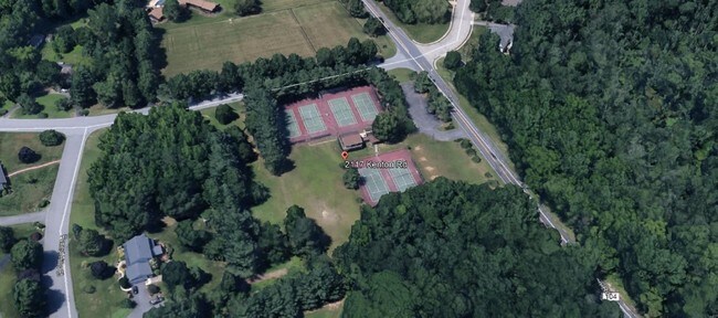
Property Record
2117 Kenton Rd, Dover, DE 19904

NEARBY LISTINGS FOR SALE OR LEASE
Property Detail
2117 Kenton Rd
2-00-06600-02-2300-000
W SD CO RD 104 3.9717 A 2117 KENTON RD
Commercialnec
Kent
AE
Delaware
10001C0162H
4 AC
2025
Kent County
2025
Philadelphia
041804
Dover, DE
1,440 SF
DEMOGRAPHICS near 2117 Kenton Rd
1 mile
3 mile
5 mile
2024 Total Population
3,362
32,961
70,507
2029 Population
3,650
35,498
75,812
Pop Growth 2024-2029
+ 8.57%
+ 7.70%
+ 7.52%
Average Age
43
39
39
2024 Total Households
1,315
12,108
26,866
HH Growth 2024-2029
+ 8.75%
+ 8.08%
+ 7.78%
Median Household Inc
$92,831
$60,760
$58,890
Avg Household Size
2.50
2.40
2.50
2024 Avg HH Vehicles
2.00
2.00
2.00
Median Home Value
$286,135
$256,996
$250,295
Median Year Built
1989
1991
1987
Nearby Places
Map Layers
Map Styles
 Street
 Aerial
Transit
 Traffic
 Biking
Places
Listings with unknown addresses are not visible on the map
- Restaurants
- Banks
- Shops
- Fitness
- Groceries
SALE & LEASE HISTORY
LISTING DATE
SALE/LEASE

Jun 21, 2018
For Sale
Nearby Properties
Address
Land Use
TOTAL SIZE
Lot Size
Zoning
Address
Land Use
TOTAL SIZE
Lot Size
Zoning
231,470 SF
213.60 AC
IO
Address
Land Use
TOTAL SIZE
Lot Size
Zoning
864,325 SF
69.60 AC
RC
Address
Land Use
TOTAL SIZE
Lot Size
Zoning
308,750 SF
102.10 AC
R10
Address
Land Use
TOTAL SIZE
Lot Size
Zoning
247,145 SF
43.71 AC
CPO
Address
Land Use
TOTAL SIZE
Lot Size
Zoning
81,711 SF
93.70 AC
IO
Address
Land Use
TOTAL SIZE
Lot Size
Zoning
95,706 SF
22.94 AC
R10
Address
Land Use
TOTAL SIZE
Lot Size
Zoning
105,846 SF
15.79 AC
SC2
Address
Land Use
TOTAL SIZE
Lot Size
Zoning
567,080 SF
30.22 AC
IPM
Address
Land Use
TOTAL SIZE
Lot Size
Zoning
179,601 SF
42.90 AC
IO
Address
Land Use
TOTAL SIZE
Lot Size
Zoning
93,186 SF
89.27 AC
IPM
Address
Land Use
TOTAL SIZE
Lot Size
Zoning
531,236 SF
84.10 AC
IPM
Address
Land Use
TOTAL SIZE
Lot Size
Zoning
129,471 SF
TND
Address
Land Use
TOTAL SIZE
Lot Size
Zoning
379,358 SF
67.30 AC
SC3
Address
Land Use
TOTAL SIZE
Lot Size
Zoning
189,000 SF
13.40 AC
RG2
Address
Land Use
TOTAL SIZE
Lot Size
Zoning
55,456 SF
43.90 AC
IO
Address
Land Use
TOTAL SIZE
Lot Size
Zoning
60,324 SF
6.70 AC
IO
Address
Land Use
TOTAL SIZE
Lot Size
Zoning
44,560 SF
8.10 AC
IO
Address
Land Use
TOTAL SIZE
Lot Size
Zoning
210,400 SF
30 AC
IPM
Address
Land Use
TOTAL SIZE
Lot Size
Zoning
421,941 SF
23.70 AC
IPM
Address
Land Use
TOTAL SIZE
Lot Size
Zoning
188,100 SF
9.70 AC
RG2
Address
Land Use
TOTAL SIZE
Lot Size
Zoning
97,248 SF
9 AC
RG2
Address
Land Use
TOTAL SIZE
Lot Size
Zoning
69,228 SF
16.90 AC
RG5
Address
Land Use
TOTAL SIZE
Lot Size
Zoning
113,226 SF
2.50 AC
IO
Address
Land Use
TOTAL SIZE
Lot Size
Zoning
105,470 SF
6.90 AC
IO
Address
Land Use
TOTAL SIZE
Lot Size
Zoning
98,669 SF
12.40 AC
C4
Address
Land Use
TOTAL SIZE
Lot Size
Zoning
1,292 SF
65.25 AC
RMH
Address
Land Use
TOTAL SIZE
Lot Size
Zoning
136,440 SF
6.60 AC
RM1
Address
Land Use
TOTAL SIZE
Lot Size
Zoning
52,250 SF
8.50 AC
RG2
Address
Land Use
TOTAL SIZE
Lot Size
Zoning
56.90 AC
IO
Address
Land Use
TOTAL SIZE
Lot Size
Zoning
199,272 SF
8.50 AC
RG1
The World's #1 Commercial Real Estate Marketplace
Connect with us
© 2026 CoStar Group
The information above has been obtained from sources believed reliable. While we do not doubt its accuracy we have not verified it and make no guarantee, warranty or representation about it. It is your responsibility to independently confirm its accuracy and completeness. Any projections, opinions, assumptions, or estimates used are for example only and do not represent the current or future performance of the property. The value of this transaction to you depends on tax and other factors which should be evaluated by your tax, financial, and legal advisors. You and your advisors should conduct a careful, independent investigation of the property to determine to your satisfaction the suitability of the property for your needs.