Property Record
2117 Nc 55 Hwy, Cary, NC 27519


NEARBY LISTINGS FOR SALE OR LEASE
-
-
View all Cary listings for sale on LoopNet.com
Property Detail
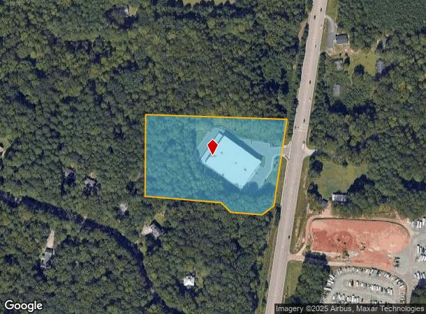
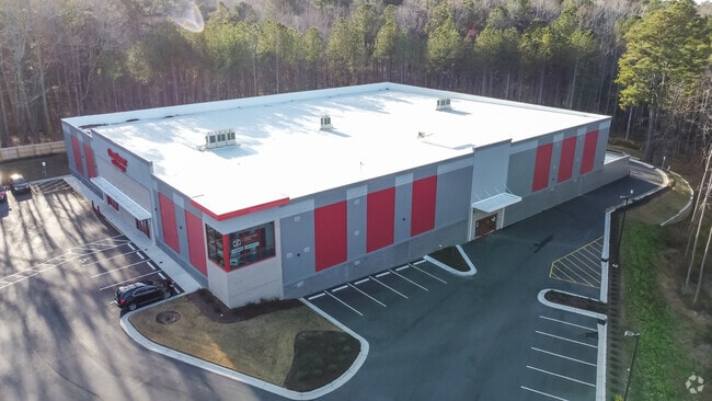
2117 Nc 55 Hwy
0733.02-65-9084-000
SRVY NC HIGHWAY 55 SELF-STORAGE BM2020-0
Publicstorage
Wake
AE
North Carolina
3720073300K
5.66 AC
2025
Cary
2025
Raleigh/Durham
053426
Raleigh-Cary, NC
114,174 SF
DEMOGRAPHICS near 2117 Nc 55 Hwy
1 Mile
3 Mile
5 Mile
2024 Total Population
9,147
71,857
192,416
2029 Population
9,950
78,071
210,006
Pop Growth 2024-2029
+ 8.78%
+ 8.65%
+ 9.14%
Average Age
37
38
38
2024 Total Households
2,961
24,756
69,408
HH Growth 2024-2029
+ 8.81%
+ 8.66%
+ 9.10%
Median Household Inc
$162,331
$148,070
$131,050
Avg Household Size
3.10
2.90
2.70
2024 Avg HH Vehicles
2.00
2.00
2.00
Median Home Value
$462,261
$460,951
$458,804
Median Year Built
1998
2001
2002
Nearby Places
Map Layers
Map Styles
 Street
 Aerial
- Restaurants
- Banks
- Shops
- Fitness
- Groceries
PUBLIC TRANSPORTATION
COMMUTER RAIL
Cary Station (Piedmont - North Carolina by Train (NC Train))
DRIVE
WALK
Distance
Cary Station (Piedmont - North Carolina by Train (NC Train))
12 min
6.7 mi
AIRPORT
Raleigh-Durham International
DRIVE
WALK
Distance
Raleigh-Durham International
20 min
13.4 mi
Freight Ports
Port of Wilmington
DRIVE
WALK
Distance
Port of Wilmington
170 min
146.9 mi
Nearby Properties
Address
Land Use
TOTAL SIZE
Lot Size
Zoning
Address
Land Use
TOTAL SIZE
Lot Size
Zoning
517,812 SF
18.51 AC
RMFP
Address
Land Use
TOTAL SIZE
Lot Size
Zoning
534,604 SF
16.38 AC
RMFM
Address
Land Use
TOTAL SIZE
Lot Size
Zoning
318,890 SF
86.86 AC
R40
Address
Land Use
TOTAL SIZE
Lot Size
Zoning
323,036 SF
30.09 AC
RMF-C
Address
Land Use
TOTAL SIZE
Lot Size
Zoning
263,023 SF
72.48 AC
R40
Address
Land Use
TOTAL SIZE
Lot Size
Zoning
313,623 SF
23.92 AC
HD MF
Address
Land Use
TOTAL SIZE
Lot Size
Zoning
294,088 SF
24.72 AC
RMF-C
Address
Land Use
TOTAL SIZE
Lot Size
Zoning
326,096 SF
15.40 AC
HD MF
Address
Land Use
TOTAL SIZE
Lot Size
Zoning
209,936 SF
55.26 AC
R8
Address
Land Use
TOTAL SIZE
Lot Size
Zoning
145,001 SF
20.31 AC
PC-CZ
Address
Land Use
TOTAL SIZE
Lot Size
Zoning
225,296 SF
9.57 AC
PUD-C
Address
Land Use
TOTAL SIZE
Lot Size
Zoning
140,005 SF
16.89 AC
LD
Address
Land Use
TOTAL SIZE
Lot Size
Zoning
157,686 SF
35.03 AC
RA
Address
Land Use
TOTAL SIZE
Lot Size
Zoning
209,191 SF
48.77 AC
LD
Address
Land Use
TOTAL SIZE
Lot Size
Zoning
121,224 SF
11.47 AC
MD
Address
Land Use
TOTAL SIZE
Lot Size
Zoning
181,188 SF
36.57 AC
OIM
Address
Land Use
TOTAL SIZE
Lot Size
Zoning
134,766 SF
8.22 AC
RMFP
Address
Land Use
TOTAL SIZE
Lot Size
Zoning
148,743 SF
10.13 AC
HD MF
Address
Land Use
TOTAL SIZE
Lot Size
Zoning
118,600 SF
4.51 AC
PUD-C
Address
Land Use
TOTAL SIZE
Lot Size
Zoning
102,311 SF
21.38 AC
R40CU
Address
Land Use
TOTAL SIZE
Lot Size
Zoning
209,053 SF
21.40 AC
PUD-C
Address
Land Use
TOTAL SIZE
Lot Size
Zoning
82,607 SF
77.97 AC
R-80W
Address
Land Use
TOTAL SIZE
Lot Size
Zoning
108,447 SF
12.04 AC
PC
Address
Land Use
TOTAL SIZE
Lot Size
Zoning
99,169 SF
9.29 AC
RA
Address
Land Use
TOTAL SIZE
Lot Size
Zoning
82,132 SF
19.10 AC
R40
Address
Land Use
TOTAL SIZE
Lot Size
Zoning
82,132 SF
22.28 AC
OIP
Address
Land Use
TOTAL SIZE
Lot Size
Zoning
62,423 SF
4.47 AC
O&I-C
Address
Land Use
TOTAL SIZE
Lot Size
Zoning
95,662 SF
2.69 AC
PUD-C
Address
Land Use
TOTAL SIZE
Lot Size
Zoning
74,612 SF
30.16 AC
PC-CU
Address
Land Use
TOTAL SIZE
Lot Size
Zoning
85,652 SF
14.61 AC
O&I-C
The World's #1 Commercial Real Estate Marketplace
Connect with us
© 2026 CoStar Group
The information above has been obtained from sources believed reliable. While we do not doubt its accuracy we have not verified it and make no guarantee, warranty or representation about it. It is your responsibility to independently confirm its accuracy and completeness. Any projections, opinions, assumptions, or estimates used are for example only and do not represent the current or future performance of the property. The value of this transaction to you depends on tax and other factors which should be evaluated by your tax, financial, and legal advisors. You and your advisors should conduct a careful, independent investigation of the property to determine to your satisfaction the suitability of the property for your needs.