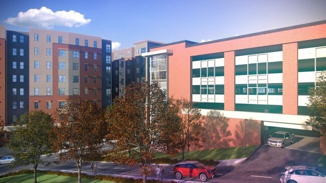
Property Record
2117 University Ave, Morgantown, WV 26505
NEARBY LISTINGS FOR SALE OR LEASE
Property Detail
2117 University Ave
Morgantown, WV
Bcechurst Addition
12-20-01210000
BL 13 LOTS 22,23 & PT LOT 21 OR .2682 AC 2175 UNIVERSITY AVENUE
Highriseapartments
Monongalia
X
West Virginia
54061C0114F
21-23
0
0.11 AC
2025
Downtown Morgantown
010103
Other Market Areas
DEMOGRAPHICS near 2117 University Ave
1 Mile
3 Mile
5 Mile
2024 Total Population
24,481
62,685
81,049
2029 Population
25,236
64,409
83,119
Pop Growth 2024-2029
+ 3.08%
+ 2.75%
+ 2.55%
Average Age
28
34
35
2024 Total Households
9,897
27,160
34,731
HH Growth 2024-2029
+ 3.38%
+ 2.87%
+ 2.65%
Median Household Inc
$26,082
$42,763
$51,420
Avg Household Size
1.80
2.00
2.10
2024 Avg HH Vehicles
1.00
2.00
2.00
Median Home Value
$205,034
$224,878
$232,417
Median Year Built
1979
1982
1985
Nearby Places
- Restaurants
- Banks
- Shops
- Fitness
- Groceries
PUBLIC TRANSPORTATION
TRANSIT/SUBWAY
Beechurst (BEE-HSC-BEE - West Virginia University Personal Rapid Transit, BEE-TOW-BEE - West Virginia University Personal Rapid Transit, BEE-WAL-BEE - West Virginia University Personal Rapid Transit, ENG-BEE-ENG - West Virginia University Personal Rapid Transit, WAL-BEE-WAL - West Virginia University Personal Rapid Transit)
DRIVE
WALK
Distance
Beechurst (BEE-HSC-BEE - West Virginia University Personal Rapid Transit, BEE-TOW-BEE - West Virginia University Personal Rapid Transit, BEE-WAL-BEE - West Virginia University Personal Rapid Transit, ENG-BEE-ENG - West Virginia University Personal Rapid Transit, WAL-BEE-WAL - West Virginia University Personal Rapid Transit)
1 min
9 min
0.5 mi
Walnut (BEE-WAL-BEE - West Virginia University Personal Rapid Transit, ENG-WAL-ENG - West Virginia University Personal Rapid Transit, HSC-WAL-HSC - West Virginia University Personal Rapid Transit, WAL-ENG-WAL - West Virginia University Personal Rapid Transit, WAL-HSC-WAL - West Virginia University Personal Rapid Transit)
DRIVE
WALK
Distance
Walnut (BEE-WAL-BEE - West Virginia University Personal Rapid Transit, ENG-WAL-ENG - West Virginia University Personal Rapid Transit, HSC-WAL-HSC - West Virginia University Personal Rapid Transit, WAL-ENG-WAL - West Virginia University Personal Rapid Transit, WAL-HSC-WAL - West Virginia University Personal Rapid Transit)
2 min
15 min
0.8 mi
Towers (BEE-TOW-BEE - West Virginia University Personal Rapid Transit, ENG-TOW-ENG - West Virginia University Personal Rapid Transit, HSC-TOW-HSC - West Virginia University Personal Rapid Transit, TOW-ENG-TOW - West Virginia University Personal Rapid Transit, TOW-HSC-TOW - West Virginia University Personal Rapid Transit)
DRIVE
WALK
Distance
Towers (BEE-TOW-BEE - West Virginia University Personal Rapid Transit, ENG-TOW-ENG - West Virginia University Personal Rapid Transit, HSC-TOW-HSC - West Virginia University Personal Rapid Transit, TOW-ENG-TOW - West Virginia University Personal Rapid Transit, TOW-HSC-TOW - West Virginia University Personal Rapid Transit)
5 min
20 min
1.1 mi
AIRPORT
North Central West Virginia
DRIVE
WALK
Distance
North Central West Virginia
41 min
33.2 mi
Freight Ports
Port of Baltimore
DRIVE
WALK
Distance
Port of Baltimore
240 min
211.2 mi
Nearby Properties
Address
Land Use
TOTAL SIZE
Lot Size
Zoning
Address
Land Use
TOTAL SIZE
Lot Size
Zoning
23.86 AC
Address
Land Use
TOTAL SIZE
Lot Size
Zoning
5.15 AC
Address
Land Use
TOTAL SIZE
Lot Size
Zoning
14.68 AC
Address
Land Use
TOTAL SIZE
Lot Size
Zoning
137.68 AC
Address
Land Use
TOTAL SIZE
Lot Size
Zoning
75.75 AC
Address
Land Use
TOTAL SIZE
Lot Size
Zoning
31.67 AC
Address
Land Use
TOTAL SIZE
Lot Size
Zoning
109.09 AC
Address
Land Use
TOTAL SIZE
Lot Size
Zoning
3.07 AC
Address
Land Use
TOTAL SIZE
Lot Size
Zoning
Address
Land Use
TOTAL SIZE
Lot Size
Zoning
19.34 AC
Address
Land Use
TOTAL SIZE
Lot Size
Zoning
7.10 AC
Address
Land Use
TOTAL SIZE
Lot Size
Zoning
45.28 AC
Address
Land Use
TOTAL SIZE
Lot Size
Zoning
15.71 AC
Address
Land Use
TOTAL SIZE
Lot Size
Zoning
30.77 AC
Address
Land Use
TOTAL SIZE
Lot Size
Zoning
53.50 AC
Address
Land Use
TOTAL SIZE
Lot Size
Zoning
Address
Land Use
TOTAL SIZE
Lot Size
Zoning
9.63 AC
Address
Land Use
TOTAL SIZE
Lot Size
Zoning
34.21 AC
Address
Land Use
TOTAL SIZE
Lot Size
Zoning
154.89 AC
Address
Land Use
TOTAL SIZE
Lot Size
Zoning
0.23 AC
Address
Land Use
TOTAL SIZE
Lot Size
Zoning
21.61 AC
Address
Land Use
TOTAL SIZE
Lot Size
Zoning
Address
Land Use
TOTAL SIZE
Lot Size
Zoning
22.71 AC
Address
Land Use
TOTAL SIZE
Lot Size
Zoning
Address
Land Use
TOTAL SIZE
Lot Size
Zoning
75.11 AC
Address
Land Use
TOTAL SIZE
Lot Size
Zoning
Address
Land Use
TOTAL SIZE
Lot Size
Zoning
9.94 AC
Address
Land Use
TOTAL SIZE
Lot Size
Zoning
18.03 AC
Address
Land Use
TOTAL SIZE
Lot Size
Zoning
61.24 AC
The World's #1 Commercial Real Estate Marketplace
Connect with us
© 2025 CoStar Group
The information above has been obtained from sources believed reliable. While we do not doubt its accuracy we have not verified it and make no guarantee, warranty or representation about it. It is your responsibility to independently confirm its accuracy and completeness. Any projections, opinions, assumptions, or estimates used are for example only and do not represent the current or future performance of the property. The value of this transaction to you depends on tax and other factors which should be evaluated by your tax, financial, and legal advisors. You and your advisors should conduct a careful, independent investigation of the property to determine to your satisfaction the suitability of the property for your needs.