Property Record
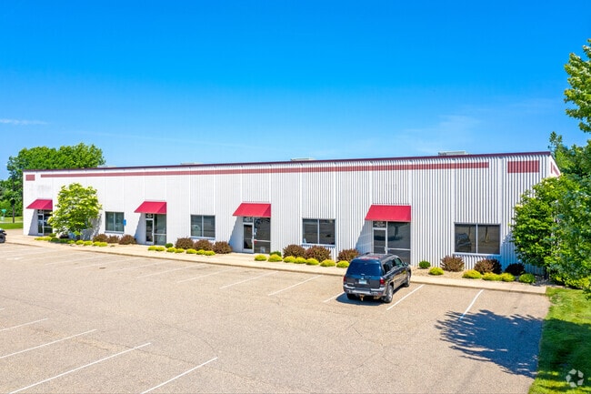
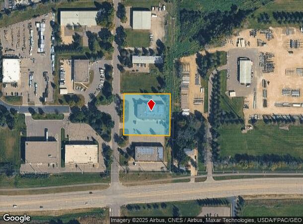
21170 Eaton Ave, Farmington, MN 55024


This Property Is For Sale
NEARBY LISTINGS FOR SALE OR LEASE
Property Detail
21170 Eaton Ave
Minneapolis-St. Paul-Bloomington, MN-WI
Farmington Industrial Park
14-25850-01-040
FARMINGTON INDUSTRIAL PARK 4 1
Industrialgeneral
Dakota
X
Minnesota
27037C0218E
40
2024
1.37 AC
2024
South Central
060902
Minneapolis/St Paul
12,151 SF
DEMOGRAPHICS near 21170 Eaton Ave
1 Mile
3 Mile
5 Mile
2024 Total Population
2,230
28,283
67,089
2029 Population
2,256
29,054
69,113
Pop Growth 2024-2029
+ 1.17%
+ 2.73%
+ 3.02%
Average Age
39
36
36
2024 Total Households
876
9,393
22,217
HH Growth 2024-2029
+ 1.14%
+ 2.64%
+ 3.09%
Median Household Inc
$95,327
$108,478
$114,585
Avg Household Size
2.50
2.90
3.00
2024 Avg HH Vehicles
2.00
2.00
2.00
Median Home Value
$346,315
$336,585
$358,448
Median Year Built
2000
1999
2000
Nearby Places
- Restaurants
- Banks
- Shops
- Fitness
- Groceries
PUBLIC TRANSPORTATION
AIRPORT
Minneapolis-St Paul International/Wold-Chamberlain
DRIVE
WALK
Distance
Minneapolis-St Paul International/Wold-Chamberlain
31 min
20.3 mi
Freight Ports
Port Milwaukee
DRIVE
WALK
Distance
Port Milwaukee
377 min
339.1 mi
Nearby Properties
Address
Land Use
TOTAL SIZE
Lot Size
Zoning
Address
Land Use
TOTAL SIZE
Lot Size
Zoning
78.77 AC
Address
Land Use
TOTAL SIZE
Lot Size
Zoning
484,566 SF
98.37 AC
Address
Land Use
TOTAL SIZE
Lot Size
Zoning
496,248 SF
28.67 AC
Address
Land Use
TOTAL SIZE
Lot Size
Zoning
360,000 SF
22.85 AC
Address
Land Use
TOTAL SIZE
Lot Size
Zoning
286,000 SF
18.85 AC
Address
Land Use
TOTAL SIZE
Lot Size
Zoning
359,914 SF
18.86 AC
Address
Land Use
TOTAL SIZE
Lot Size
Zoning
248,545 SF
21.65 AC
Address
Land Use
TOTAL SIZE
Lot Size
Zoning
147,983 SF
46.75 AC
Address
Land Use
TOTAL SIZE
Lot Size
Zoning
147,426 SF
29.47 AC
Address
Land Use
TOTAL SIZE
Lot Size
Zoning
160,611 SF
14.08 AC
Address
Land Use
TOTAL SIZE
Lot Size
Zoning
141,819 SF
12.95 AC
Address
Land Use
TOTAL SIZE
Lot Size
Zoning
151,200 SF
17.20 AC
Address
Land Use
TOTAL SIZE
Lot Size
Zoning
12.51 AC
Address
Land Use
TOTAL SIZE
Lot Size
Zoning
79,076 SF
3.14 AC
Address
Land Use
TOTAL SIZE
Lot Size
Zoning
61,674 SF
10.31 AC
Address
Land Use
TOTAL SIZE
Lot Size
Zoning
131,634 SF
10.76 AC
Address
Land Use
TOTAL SIZE
Lot Size
Zoning
118,065 SF
7.63 AC
Address
Land Use
TOTAL SIZE
Lot Size
Zoning
137,542 SF
11.85 AC
Address
Land Use
TOTAL SIZE
Lot Size
Zoning
99,365 SF
0.50 AC
Address
Land Use
TOTAL SIZE
Lot Size
Zoning
92,744 SF
31.10 AC
Address
Land Use
TOTAL SIZE
Lot Size
Zoning
105,147 SF
6.32 AC
Address
Land Use
TOTAL SIZE
Lot Size
Zoning
94,244 SF
4.06 AC
Address
Land Use
TOTAL SIZE
Lot Size
Zoning
176,291 SF
13.79 AC
Address
Land Use
TOTAL SIZE
Lot Size
Zoning
48,990 SF
1.19 AC
Address
Land Use
TOTAL SIZE
Lot Size
Zoning
205,400 SF
13.02 AC
Address
Land Use
TOTAL SIZE
Lot Size
Zoning
68,964 SF
5.48 AC
Address
Land Use
TOTAL SIZE
Lot Size
Zoning
105,040 SF
19.97 AC
Address
Land Use
TOTAL SIZE
Lot Size
Zoning
77,816 SF
18.01 AC
Address
Land Use
TOTAL SIZE
Lot Size
Zoning
165,938 SF
6.99 AC
Address
Land Use
TOTAL SIZE
Lot Size
Zoning
43,280 SF
20 AC
The World's #1 Commercial Real Estate Marketplace
Connect with us
© 2025 CoStar Group
The information above has been obtained from sources believed reliable. While we do not doubt its accuracy we have not verified it and make no guarantee, warranty or representation about it. It is your responsibility to independently confirm its accuracy and completeness. Any projections, opinions, assumptions, or estimates used are for example only and do not represent the current or future performance of the property. The value of this transaction to you depends on tax and other factors which should be evaluated by your tax, financial, and legal advisors. You and your advisors should conduct a careful, independent investigation of the property to determine to your satisfaction the suitability of the property for your needs.