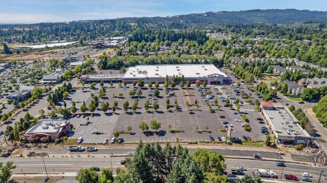
Property Record
21170 Sw Langer Farms Pky, Sherwood, OR 97140


NEARBY LISTINGS FOR SALE OR LEASE
Property Detail
21170 Sw Langer Farms Pky
Portland-Vancouver-Hillsboro, OR-WA
2004-037 Partition Plat
R2128768
2004-037 PARTITION PLAT, LOT 2, ACRES 2.06
Commercialbuilding
Washington
X
Oregon
41067C0602F
2
2024
2.06 AC
2026
Sherwood
032112
Portland
19,300 SF
DEMOGRAPHICS near 21170 Sw Langer Farms Pky
1 Mile
3 Mile
5 Mile
2024 Total Population
9,491
39,786
126,950
2029 Population
9,584
39,917
127,660
Pop Growth 2024-2029
+ 0.98%
+ 0.33%
+ 0.56%
Average Age
38
40
40
2024 Total Households
3,345
14,288
48,197
HH Growth 2024-2029
+ 1.08%
+ 0.43%
+ 0.59%
Median Household Inc
$93,873
$107,670
$103,392
Avg Household Size
2.80
2.70
2.60
2024 Avg HH Vehicles
2.00
2.00
2.00
Median Home Value
$487,290
$538,693
$558,357
Median Year Built
1996
1995
1993
Nearby Places
Map Layers
Map Styles
 Street
 Aerial
- Restaurants
- Banks
- Shops
- Fitness
- Groceries
PUBLIC TRANSPORTATION
COMMUTER RAIL
Tualatin (Westside Express Service - Tri-County Metropolitan Transportation District of Oregon Rail (TriMet Rail))
DRIVE
WALK
Distance
Tualatin (Westside Express Service - Tri-County Metropolitan Transportation District of Oregon Rail (TriMet Rail))
8 min
4.0 mi
Tigard Transit Center (Westside Express Service - Tri-County Metropolitan Transportation District of Oregon Rail (TriMet Rail))
DRIVE
WALK
Distance
Tigard Transit Center (Westside Express Service - Tri-County Metropolitan Transportation District of Oregon Rail (TriMet Rail))
14 min
6.4 mi
AIRPORT
Portland International
DRIVE
WALK
Distance
Portland International
44 min
27.9 mi
Freight Ports
Port of Portland
DRIVE
WALK
Distance
Port of Portland
31 min
19.1 mi
SALE & LEASE HISTORY
LISTING DATE
SALE/LEASE

Sep 25, 2016
For Lease
Feb 05, 2021
For Lease
Nearby Properties
Address
Land Use
TOTAL SIZE
Lot Size
Zoning
Address
Land Use
TOTAL SIZE
Lot Size
Zoning
23.98 AC
EI
Address
Land Use
TOTAL SIZE
Lot Size
Zoning
508,000 SF
69.72 AC
PFC
Address
Land Use
TOTAL SIZE
Lot Size
Zoning
353,000 SF
69.95 AC
IP
Address
Land Use
TOTAL SIZE
Lot Size
Zoning
27.23 AC
MP
Address
Land Use
TOTAL SIZE
Lot Size
Zoning
0.14 AC
MG
Address
Land Use
TOTAL SIZE
Lot Size
Zoning
27.85 AC
IP
Address
Land Use
TOTAL SIZE
Lot Size
Zoning
9.12 AC
R-7
Address
Land Use
TOTAL SIZE
Lot Size
Zoning
1,232 SF
27.77 AC
EI
Address
Land Use
TOTAL SIZE
Lot Size
Zoning
18.06 AC
Address
Land Use
TOTAL SIZE
Lot Size
Zoning
127,476 SF
13.48 AC
RC
Address
Land Use
TOTAL SIZE
Lot Size
Zoning
68,450 SF
19.39 AC
ML
Address
Land Use
TOTAL SIZE
Lot Size
Zoning
139,356 SF
13.99 AC
LI_PUD
Address
Land Use
TOTAL SIZE
Lot Size
Zoning
15,000 SF
21.08 AC
MG
Address
Land Use
TOTAL SIZE
Lot Size
Zoning
18.55 AC
EI
Address
Land Use
TOTAL SIZE
Lot Size
Zoning
22.05 AC
MP
Address
Land Use
TOTAL SIZE
Lot Size
Zoning
168,065 SF
5.09 AC
HDR_PUD
Address
Land Use
TOTAL SIZE
Lot Size
Zoning
225,780 SF
10.01 AC
R-24
Address
Land Use
TOTAL SIZE
Lot Size
Zoning
261,104 SF
13.52 AC
HDR_PUD
Address
Land Use
TOTAL SIZE
Lot Size
Zoning
13.76 AC
RMH
Address
Land Use
TOTAL SIZE
Lot Size
Zoning
220,472 SF
8.99 AC
RH
Address
Land Use
TOTAL SIZE
Lot Size
Zoning
1,360 SF
7.41 AC
HDR
Address
Land Use
TOTAL SIZE
Lot Size
Zoning
124,718 SF
10.89 AC
RC_PUD
Address
Land Use
TOTAL SIZE
Lot Size
Zoning
145,000 SF
4.01 AC
RC
Address
Land Use
TOTAL SIZE
Lot Size
Zoning
226,960 SF
11.38 AC
MG
Address
Land Use
TOTAL SIZE
Lot Size
Zoning
13 AC
MP
Address
Land Use
TOTAL SIZE
Lot Size
Zoning
5.35 AC
ML
Address
Land Use
TOTAL SIZE
Lot Size
Zoning
190,000 SF
24.86 AC
IP
Address
Land Use
TOTAL SIZE
Lot Size
Zoning
1,089 SF
8.97 AC
MG
The World's #1 Commercial Real Estate Marketplace
Connect with us
© 2026 CoStar Group
The information above has been obtained from sources believed reliable. While we do not doubt its accuracy we have not verified it and make no guarantee, warranty or representation about it. It is your responsibility to independently confirm its accuracy and completeness. Any projections, opinions, assumptions, or estimates used are for example only and do not represent the current or future performance of the property. The value of this transaction to you depends on tax and other factors which should be evaluated by your tax, financial, and legal advisors. You and your advisors should conduct a careful, independent investigation of the property to determine to your satisfaction the suitability of the property for your needs.