Property Record
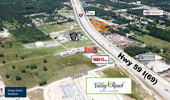
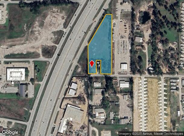
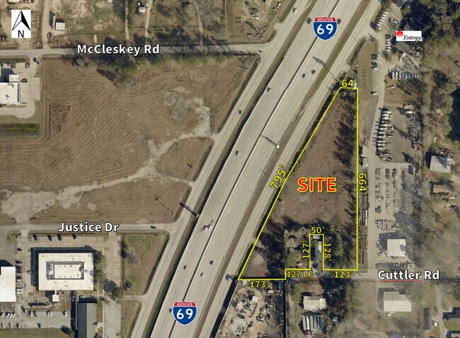
21173 Us Highway 59, New Caney, TX 77357
NEARBY LISTINGS FOR SALE OR LEASE
Property Detail
21173 Us Highway 59
0392-01-01900
Mcnaughton Findley
Commercialnec
A0392 - MCNAUGHTON FINDLEY, TRACT 19, 19-A, ACRES 3.3169
X
Montgomery
48339C0600G
Texas
2024
3.32 AC
2025
Kingwood/Humble
692802
Houston
1,540 SF
Houston-The Woodlands-Sugar Land, TX
DEMOGRAPHICS near 21173 Us Highway 59
1 Mile
3 Mile
5 Mile
2024 Total Population
3,725
34,781
88,025
2029 Population
4,638
43,275
106,991
Pop Growth 2024-2029
+ 24.51%
+ 24.42%
+ 21.55%
Average Age
35
34
36
2024 Total Households
1,233
11,308
29,097
HH Growth 2024-2029
+ 24.74%
+ 24.64%
+ 21.67%
Median Household Inc
$68,806
$77,736
$78,444
Avg Household Size
3.00
3.00
3.00
2024 Avg HH Vehicles
2.00
2.00
2.00
Median Home Value
$124,019
$215,374
$230,830
Median Year Built
2002
2006
2003
Nearby Places
Map Layers
Map Styles
 Street
 Aerial
- Restaurants
- Banks
- Shops
- Fitness
- Groceries
PUBLIC TRANSPORTATION
AIRPORT
George Bush Intcntl/Houston
DRIVE
WALK
Distance
George Bush Intcntl/Houston
27 min
19.2 mi
Freight Ports
Port of Houston
DRIVE
WALK
Distance
Port of Houston
48 min
34.5 mi
SALE & LEASE HISTORY
LISTING DATE
SALE/LEASE

Apr 24, 2017
For Sale
Nearby Properties
Address
Land Use
TOTAL SIZE
Lot Size
Zoning
Address
Land Use
TOTAL SIZE
Lot Size
Zoning
430,982 SF
21.50 AC
Address
Land Use
TOTAL SIZE
Lot Size
Zoning
298,715 SF
16.28 AC
Address
Land Use
TOTAL SIZE
Lot Size
Zoning
444,537 SF
55.21 AC
5
Address
Land Use
TOTAL SIZE
Lot Size
Zoning
274,809 SF
11.89 AC
Address
Land Use
TOTAL SIZE
Lot Size
Zoning
29,782 SF
28.69 AC
Address
Land Use
TOTAL SIZE
Lot Size
Zoning
154,584 SF
46.76 AC
Address
Land Use
TOTAL SIZE
Lot Size
Zoning
161,302 SF
60.09 AC
5
Address
Land Use
TOTAL SIZE
Lot Size
Zoning
187,696 SF
20.07 AC
Address
Land Use
TOTAL SIZE
Lot Size
Zoning
149,963 SF
49.98 AC
Address
Land Use
TOTAL SIZE
Lot Size
Zoning
215,554 SF
20.89 AC
5
Address
Land Use
TOTAL SIZE
Lot Size
Zoning
76,292 SF
32.01 AC
5
Address
Land Use
TOTAL SIZE
Lot Size
Zoning
165,381 SF
16.60 AC
Address
Land Use
TOTAL SIZE
Lot Size
Zoning
224,810 SF
21.64 AC
5
Address
Land Use
TOTAL SIZE
Lot Size
Zoning
38,994 SF
4.82 AC
5
Address
Land Use
TOTAL SIZE
Lot Size
Zoning
121,871 SF
12.59 AC
Address
Land Use
TOTAL SIZE
Lot Size
Zoning
131,364 SF
4.63 AC
5
Address
Land Use
TOTAL SIZE
Lot Size
Zoning
131,028 SF
9.46 AC
Address
Land Use
TOTAL SIZE
Lot Size
Zoning
51,659 SF
8.81 AC
Address
Land Use
TOTAL SIZE
Lot Size
Zoning
113,545 SF
10.70 AC
Address
Land Use
TOTAL SIZE
Lot Size
Zoning
128,724 SF
29.89 AC
Address
Land Use
TOTAL SIZE
Lot Size
Zoning
110,013 SF
13.91 AC
5
Address
Land Use
TOTAL SIZE
Lot Size
Zoning
117,146 SF
8.25 AC
5
Address
Land Use
TOTAL SIZE
Lot Size
Zoning
102,184 SF
20.35 AC
Address
Land Use
TOTAL SIZE
Lot Size
Zoning
90,142 SF
10.80 AC
5
Address
Land Use
TOTAL SIZE
Lot Size
Zoning
72,839 SF
5.91 AC
Address
Land Use
TOTAL SIZE
Lot Size
Zoning
53,236 SF
6.80 AC
Address
Land Use
TOTAL SIZE
Lot Size
Zoning
102,279 SF
2.18 AC
Address
Land Use
TOTAL SIZE
Lot Size
Zoning
47,145 SF
4.31 AC
Address
Land Use
TOTAL SIZE
Lot Size
Zoning
78,027 SF
13.40 AC
5
The World's #1 Commercial Real Estate Marketplace
Connect with us
© 2025 CoStar Group
The information above has been obtained from sources believed reliable. While we do not doubt its accuracy we have not verified it and make no guarantee, warranty or representation about it. It is your responsibility to independently confirm its accuracy and completeness. Any projections, opinions, assumptions, or estimates used are for example only and do not represent the current or future performance of the property. The value of this transaction to you depends on tax and other factors which should be evaluated by your tax, financial, and legal advisors. You and your advisors should conduct a careful, independent investigation of the property to determine to your satisfaction the suitability of the property for your needs.