Property Record
2118 Abrams Rd, Dallas, TX 75214
NEARBY LISTINGS FOR SALE OR LEASE
-
-
-
-
-
-
-
-
-
No Photo
-
View all Dallas listings for sale on LoopNet.com
Property Detail
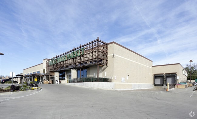
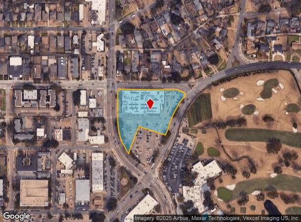
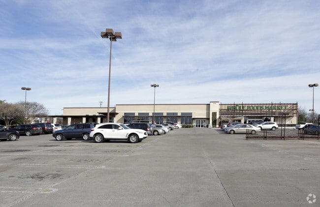
2118 Abrams Rd
Dallas-Fort Worth-Arlington, TX
Minyard 1
002787000A01B0000
MINYARD 1 BLK A/2787 LOT 1B ACS 2.7127 INT201200291993 DD09072012 CO-DC 2787 00A 01B00 7DA2787 00A
Supermarket
Dallas
X
Texas
48113C0335K
1b
2024
2.71 AC
2025
Lakewood
000100
Dallas/Ft Worth
43,101 SF
DEMOGRAPHICS near 2118 Abrams Rd
1 Mile
3 Mile
5 Mile
2024 Total Population
17,778
170,675
443,115
2029 Population
17,736
171,959
445,620
Pop Growth 2024-2029
(0.24%)
+ 0.75%
+ 0.57%
Average Age
38
37
37
2024 Total Households
8,053
84,554
207,464
HH Growth 2024-2029
(0.27%)
+ 0.89%
+ 0.70%
Median Household Inc
$107,414
$81,271
$72,175
Avg Household Size
2.20
1.90
2.00
2024 Avg HH Vehicles
2.00
2.00
2.00
Median Home Value
$659,392
$487,814
$445,821
Median Year Built
1958
1987
1985
Nearby Places
Map Layers
Map Styles
 Street
 Aerial
- Restaurants
- Banks
- Shops
- Fitness
- Groceries
PUBLIC TRANSPORTATION
COMMUTER RAIL
Victory Station (DART LIGHT RAIL - GREEN LINE - Dallas Area Rapid Transit (DART), DART LIGHT RAIL - ORANGE LINE - Dallas Area Rapid Transit (DART), TRINITY RAILWAY - Dallas Area Rapid Transit (DART))
DRIVE
WALK
Distance
Victory Station (DART LIGHT RAIL - GREEN LINE - Dallas Area Rapid Transit (DART), DART LIGHT RAIL - ORANGE LINE - Dallas Area Rapid Transit (DART), TRINITY RAILWAY - Dallas Area Rapid Transit (DART))
12 min
5.5 mi
Medical/Market Ctr Station (TRINITY RAILWAY - Dallas Area Rapid Transit (DART))
DRIVE
WALK
Distance
Medical/Market Ctr Station (TRINITY RAILWAY - Dallas Area Rapid Transit (DART))
15 min
6.3 mi
AIRPORT
Dallas Love Field
DRIVE
WALK
Distance
Dallas Love Field
17 min
7.7 mi
Dallas-Fort Worth International
DRIVE
WALK
Distance
Dallas-Fort Worth International
36 min
23.8 mi
Freight Ports
Port of Shreveport
DRIVE
WALK
Distance
Port of Shreveport
211 min
194.9 mi
Nearby Properties
Address
Land Use
TOTAL SIZE
Lot Size
Zoning
Address
Land Use
TOTAL SIZE
Lot Size
Zoning
1,634,356 SF
92.90 AC
Z421
Address
Land Use
TOTAL SIZE
Lot Size
Zoning
858,872 SF
23.90 AC
Z421
Address
Land Use
TOTAL SIZE
Lot Size
Zoning
100 SF
27.05 AC
Z421
Address
Land Use
TOTAL SIZE
Lot Size
Zoning
226,331 SF
1.12 AC
Address
Land Use
TOTAL SIZE
Lot Size
Zoning
2,695,010 SF
8.69 AC
Z239
Address
Land Use
TOTAL SIZE
Lot Size
Zoning
545,752 SF
1.33 AC
Z239
Address
Land Use
TOTAL SIZE
Lot Size
Zoning
763,340 SF
8.31 AC
Z165
Address
Land Use
TOTAL SIZE
Lot Size
Zoning
447,418 SF
5.69 AC
Z236
Address
Land Use
TOTAL SIZE
Lot Size
Zoning
446,593 SF
0.93 AC
Address
Land Use
TOTAL SIZE
Lot Size
Zoning
3,398,834 SF
13.45 AC
Z151
Address
Land Use
TOTAL SIZE
Lot Size
Zoning
659,884 SF
5.77 AC
Z151
Address
Land Use
TOTAL SIZE
Lot Size
Zoning
814,976 SF
8.72 AC
Z151
Address
Land Use
TOTAL SIZE
Lot Size
Zoning
801,209 SF
1.57 AC
Z239
Address
Land Use
TOTAL SIZE
Lot Size
Zoning
593,031 SF
4.66 AC
Address
Land Use
TOTAL SIZE
Lot Size
Zoning
595,955 SF
1.42 AC
Z239
Address
Land Use
TOTAL SIZE
Lot Size
Zoning
474,563 SF
2.42 AC
Z239
Address
Land Use
TOTAL SIZE
Lot Size
Zoning
749,138 SF
2.17 AC
Z239
Address
Land Use
TOTAL SIZE
Lot Size
Zoning
2,948 SF
25.35 AC
Z164
Address
Land Use
TOTAL SIZE
Lot Size
Zoning
240,205 SF
1.24 AC
Address
Land Use
TOTAL SIZE
Lot Size
Zoning
551,820 SF
5.03 AC
Z239
Address
Land Use
TOTAL SIZE
Lot Size
Zoning
655,025 SF
3.53 AC
Z239
Address
Land Use
TOTAL SIZE
Lot Size
Zoning
717,809 SF
4.88 AC
Z239
Address
Land Use
TOTAL SIZE
Lot Size
Zoning
671,830 SF
3.16 AC
Z239
Address
Land Use
TOTAL SIZE
Lot Size
Zoning
583,186 SF
4.54 AC
Z239
Address
Land Use
TOTAL SIZE
Lot Size
Zoning
611,755 SF
6.11 AC
Z151
Address
Land Use
TOTAL SIZE
Lot Size
Zoning
475,860 SF
1.27 AC
Z151
Address
Land Use
TOTAL SIZE
Lot Size
Zoning
567,135 SF
4.09 AC
Z239
Address
Land Use
TOTAL SIZE
Lot Size
Zoning
215,548 SF
8.15 AC
Z192
Address
Land Use
TOTAL SIZE
Lot Size
Zoning
514,225 SF
2.83 AC
Z239
Address
Land Use
TOTAL SIZE
Lot Size
Zoning
553,134 SF
3.03 AC
Z239
The World's #1 Commercial Real Estate Marketplace
Connect with us
© 2025 CoStar Group
The information above has been obtained from sources believed reliable. While we do not doubt its accuracy we have not verified it and make no guarantee, warranty or representation about it. It is your responsibility to independently confirm its accuracy and completeness. Any projections, opinions, assumptions, or estimates used are for example only and do not represent the current or future performance of the property. The value of this transaction to you depends on tax and other factors which should be evaluated by your tax, financial, and legal advisors. You and your advisors should conduct a careful, independent investigation of the property to determine to your satisfaction the suitability of the property for your needs.