Property Record
2118 Route 715, Stroudsburg, PA 18360
NEARBY LISTINGS FOR SALE OR LEASE
-
-
No Photo
-
-
View all Stroudsburg listings for lease on LoopNet.com
Property Detail
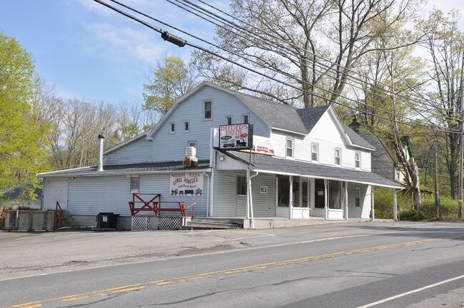
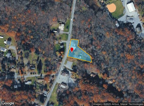
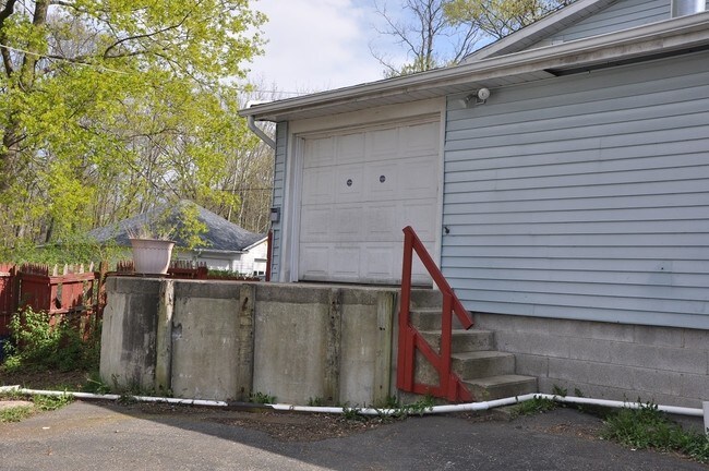
2118 Route 715
08.4.1.58
Reeders General Store
Storebuilding
Monroe
X
Pennsylvania
42089C0265E
1.10 AC
2025
Monroe County
2025
Philadelphia
300406
East Stroudsburg, PA
3,692 SF
DEMOGRAPHICS near 2118 Route 715
1 Mile
3 Mile
5 Mile
2024 Total Population
673
7,120
24,457
2029 Population
654
7,043
24,262
Pop Growth 2024-2029
(2.82%)
(1.08%)
(0.80%)
Average Age
45
44
44
2024 Total Households
259
2,721
9,148
HH Growth 2024-2029
(2.70%)
(1.07%)
(0.83%)
Median Household Inc
$92,682
$92,488
$86,573
Avg Household Size
2.60
2.60
2.60
2024 Avg HH Vehicles
2.00
2.00
2.00
Median Home Value
$284,615
$256,165
$244,222
Median Year Built
1979
1981
1983
Nearby Places
- Restaurants
- Banks
- Shops
- Fitness
- Groceries
PUBLIC TRANSPORTATION
AIRPORT
Lehigh Valley International
DRIVE
WALK
Distance
Lehigh Valley International
54 min
35.2 mi
Freight Ports
Maher Terminal
DRIVE
WALK
Distance
Maher Terminal
103 min
80.3 mi
SALE & LEASE HISTORY
LISTING DATE
SALE/LEASE

Sep 30, 2019
For Sale
Nov 13, 2019
For Lease
May 16, 2017
For Sale
Jul 10, 2018
For Sale
Nearby Properties
Address
Land Use
TOTAL SIZE
Lot Size
Zoning
Address
Land Use
TOTAL SIZE
Lot Size
Zoning
64,000 SF
23.31 AC
C
Address
Land Use
TOTAL SIZE
Lot Size
Zoning
124,288 SF
10.58 AC
C
Address
Land Use
TOTAL SIZE
Lot Size
Zoning
40,418 SF
78.43 AC
C
Address
Land Use
TOTAL SIZE
Lot Size
Zoning
174,532 SF
56.85 AC
R-2
Address
Land Use
TOTAL SIZE
Lot Size
Zoning
1,024 SF
147.49 AC
RD
Address
Land Use
TOTAL SIZE
Lot Size
Zoning
57,088 SF
58.47 AC
C
Address
Land Use
TOTAL SIZE
Lot Size
Zoning
72,386 SF
19.74 AC
C
Address
Land Use
TOTAL SIZE
Lot Size
Zoning
79,200 SF
67.68 AC
C
Address
Land Use
TOTAL SIZE
Lot Size
Zoning
103,185 SF
39.71 AC
C
Address
Land Use
TOTAL SIZE
Lot Size
Zoning
2,414 AC
CV
Address
Land Use
TOTAL SIZE
Lot Size
Zoning
38,158 SF
9.95 AC
C
Address
Land Use
TOTAL SIZE
Lot Size
Zoning
53,505 SF
Address
Land Use
TOTAL SIZE
Lot Size
Zoning
42,825 SF
1 AC
Address
Land Use
TOTAL SIZE
Lot Size
Zoning
48,622 SF
2.47 AC
C
Address
Land Use
TOTAL SIZE
Lot Size
Zoning
78,842 SF
7.24 AC
RD
Address
Land Use
TOTAL SIZE
Lot Size
Zoning
7,767 SF
Address
Land Use
TOTAL SIZE
Lot Size
Zoning
51,060 SF
7 AC
C
Address
Land Use
TOTAL SIZE
Lot Size
Zoning
7,488 SF
5.74 AC
C
Address
Land Use
TOTAL SIZE
Lot Size
Zoning
62,147 SF
39.87 AC
C
Address
Land Use
TOTAL SIZE
Lot Size
Zoning
4,106 SF
4.32 AC
C
Address
Land Use
TOTAL SIZE
Lot Size
Zoning
21,900 SF
6.11 AC
R-1
Address
Land Use
TOTAL SIZE
Lot Size
Zoning
2,000 SF
55.50 AC
I
Address
Land Use
TOTAL SIZE
Lot Size
Zoning
20,129 SF
5.20 AC
C
Address
Land Use
TOTAL SIZE
Lot Size
Zoning
25,214 SF
11.39 AC
C
Address
Land Use
TOTAL SIZE
Lot Size
Zoning
19,840 SF
3.98 AC
C
Address
Land Use
TOTAL SIZE
Lot Size
Zoning
19,634 SF
10.20 AC
RC
Address
Land Use
TOTAL SIZE
Lot Size
Zoning
5,932 SF
2.47 AC
C
Address
Land Use
TOTAL SIZE
Lot Size
Zoning
13,680 SF
1 AC
R2
Address
Land Use
TOTAL SIZE
Lot Size
Zoning
9,184 SF
5.20 AC
C
Address
Land Use
TOTAL SIZE
Lot Size
Zoning
40,684 SF
1.45 AC
C
The World's #1 Commercial Real Estate Marketplace
Connect with us
© 2025 CoStar Group
The information above has been obtained from sources believed reliable. While we do not doubt its accuracy we have not verified it and make no guarantee, warranty or representation about it. It is your responsibility to independently confirm its accuracy and completeness. Any projections, opinions, assumptions, or estimates used are for example only and do not represent the current or future performance of the property. The value of this transaction to you depends on tax and other factors which should be evaluated by your tax, financial, and legal advisors. You and your advisors should conduct a careful, independent investigation of the property to determine to your satisfaction the suitability of the property for your needs.