Property Record
2133 10Th St, Floresville, TX 78114
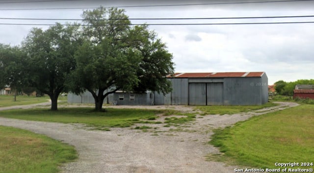
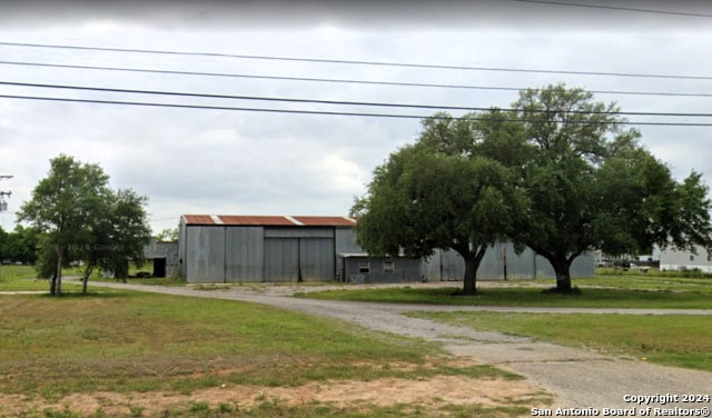
This Property Is For Sale
NEARBY LISTINGS FOR SALE OR LEASE
Property Detail
2133 10Th St
San Antonio-New Braunfels, TX
Floresville Sections
42228
FLORESVILLE SECTIONS, LOT 18 (SEC 5), ACRES .93
Mobilemanufacturedhomeregardlessoflandownership
Wilson
X
Texas
48493C0295C
18
2024
0.17 AC
2025
Wilson County
000300
San Antonio
1,344 SF
DEMOGRAPHICS near 2133 10Th St
1 Mile
3 Mile
5 Mile
2024 Total Population
3,704
9,859
11,619
2029 Population
4,264
11,462
13,475
Pop Growth 2024-2029
+ 15.12%
+ 16.26%
+ 15.97%
Average Age
41
39
39
2024 Total Households
1,358
3,454
4,066
HH Growth 2024-2029
+ 15.39%
+ 16.36%
+ 16.04%
Median Household Inc
$47,089
$56,387
$58,786
Avg Household Size
2.60
2.80
2.80
2024 Avg HH Vehicles
2.00
2.00
2.00
Median Home Value
$190,487
$200,905
$207,749
Median Year Built
1996
1996
1997
Nearby Places
Map Layers
Map Styles
 Street
 Aerial
- Restaurants
- Banks
- Shops
- Fitness
- Groceries
PUBLIC TRANSPORTATION
AIRPORT
San Antonio International
DRIVE
WALK
Distance
San Antonio International
46 min
37.7 mi
Nearby Properties
Address
Land Use
TOTAL SIZE
Lot Size
Zoning
Address
Land Use
TOTAL SIZE
Lot Size
Zoning
393,054 SF
22 AC
Address
Land Use
TOTAL SIZE
Lot Size
Zoning
171,012 SF
15 AC
Address
Land Use
TOTAL SIZE
Lot Size
Zoning
123,282 SF
12 AC
Address
Land Use
TOTAL SIZE
Lot Size
Zoning
75,075 SF
9.87 AC
Address
Land Use
TOTAL SIZE
Lot Size
Zoning
112,280 SF
11.15 AC
Address
Land Use
TOTAL SIZE
Lot Size
Zoning
45,493 SF
101.82 AC
Address
Land Use
TOTAL SIZE
Lot Size
Zoning
115,206 SF
17.19 AC
Address
Land Use
TOTAL SIZE
Lot Size
Zoning
32,976 SF
4.50 AC
Address
Land Use
TOTAL SIZE
Lot Size
Zoning
44,336 SF
3.11 AC
Address
Land Use
TOTAL SIZE
Lot Size
Zoning
34,920 SF
19.95 AC
Address
Land Use
TOTAL SIZE
Lot Size
Zoning
44,685 SF
10 AC
Address
Land Use
TOTAL SIZE
Lot Size
Zoning
37,852 SF
9.35 AC
Address
Land Use
TOTAL SIZE
Lot Size
Zoning
70,216 SF
43 AC
Address
Land Use
TOTAL SIZE
Lot Size
Zoning
29,538 SF
3.86 AC
Address
Land Use
TOTAL SIZE
Lot Size
Zoning
19,860 SF
9.77 AC
Address
Land Use
TOTAL SIZE
Lot Size
Zoning
33,882 SF
218.11 AC
Address
Land Use
TOTAL SIZE
Lot Size
Zoning
22,969 SF
10.32 AC
Address
Land Use
TOTAL SIZE
Lot Size
Zoning
46,910 SF
23 AC
Address
Land Use
TOTAL SIZE
Lot Size
Zoning
17,400 SF
4.72 AC
Address
Land Use
TOTAL SIZE
Lot Size
Zoning
12,918 SF
2.02 AC
Address
Land Use
TOTAL SIZE
Lot Size
Zoning
45,350 SF
2.37 AC
Address
Land Use
TOTAL SIZE
Lot Size
Zoning
61,439 SF
7.16 AC
Address
Land Use
TOTAL SIZE
Lot Size
Zoning
20,962 SF
Address
Land Use
TOTAL SIZE
Lot Size
Zoning
25,073 SF
0.69 AC
Address
Land Use
TOTAL SIZE
Lot Size
Zoning
33,162 SF
4 AC
Address
Land Use
TOTAL SIZE
Lot Size
Zoning
41,311 SF
4.19 AC
Address
Land Use
TOTAL SIZE
Lot Size
Zoning
15,900 SF
2.24 AC
Address
Land Use
TOTAL SIZE
Lot Size
Zoning
9,876 SF
1.40 AC
Address
Land Use
TOTAL SIZE
Lot Size
Zoning
7,430 SF
2.85 AC
Address
Land Use
TOTAL SIZE
Lot Size
Zoning
14,040 SF
1.98 AC
The World's #1 Commercial Real Estate Marketplace
Connect with us
© 2026 CoStar Group
The information above has been obtained from sources believed reliable. While we do not doubt its accuracy we have not verified it and make no guarantee, warranty or representation about it. It is your responsibility to independently confirm its accuracy and completeness. Any projections, opinions, assumptions, or estimates used are for example only and do not represent the current or future performance of the property. The value of this transaction to you depends on tax and other factors which should be evaluated by your tax, financial, and legal advisors. You and your advisors should conduct a careful, independent investigation of the property to determine to your satisfaction the suitability of the property for your needs.