Property Record
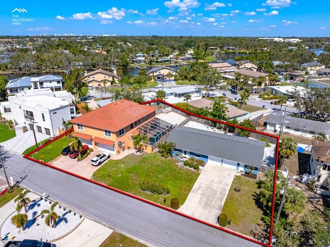
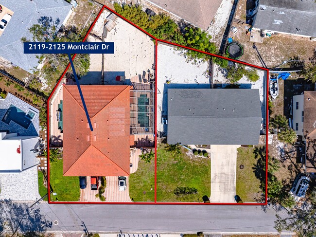
2119 Montclair Dr, Sarasota, FL 34231
This Property Is For Sale
NEARBY LISTINGS FOR SALE OR LEASE
Property Detail
2119 Montclair Dr
North Port-Sarasota-Bradenton, FL
Montclair Villas
0086-12-1001
Sarasota
Duplex
Florida
X
0.08 AC
12115C0144G
South Sarasota
2,036 SF
Tampa/St Petersburg
DEMOGRAPHICS near 2119 Montclair Dr
1 Mile
3 Mile
5 Mile
2024 Total Population
8,406
62,651
150,035
2029 Population
9,645
71,948
171,246
Pop Growth 2024-2029
+ 14.74%
+ 14.84%
+ 14.14%
Average Age
52
51
51
2024 Total Households
4,101
30,032
71,518
HH Growth 2024-2029
+ 14.90%
+ 15.07%
+ 14.40%
Median Household Inc
$75,864
$77,661
$75,580
Avg Household Size
2.00
2.00
2.00
2024 Avg HH Vehicles
2.00
2.00
2.00
Median Home Value
$423,424
$409,532
$387,473
Median Year Built
1976
1975
1978
Nearby Places
- Restaurants
- Banks
- Shops
- Fitness
- Groceries
PUBLIC TRANSPORTATION
AIRPORT
Sarasota/Bradenton International
DRIVE
WALK
Distance
Sarasota/Bradenton International
24 min
10.5 mi
Freight Ports
Port Manatee
DRIVE
WALK
Distance
Port Manatee
50 min
28.6 mi
Nearby Properties
Address
Land Use
TOTAL SIZE
Lot Size
Zoning
Address
Land Use
TOTAL SIZE
Lot Size
Zoning
595,745 SF
42.33 AC
GU
Address
Land Use
TOTAL SIZE
Lot Size
Zoning
437,836 SF
72.05 AC
GU
Address
Land Use
TOTAL SIZE
Lot Size
Zoning
912,253 SF
43.46 AC
PID
Address
Land Use
TOTAL SIZE
Lot Size
Zoning
312,294 SF
40.21 AC
OPI
Address
Land Use
TOTAL SIZE
Lot Size
Zoning
11,781 SF
43.95 AC
GU
Address
Land Use
TOTAL SIZE
Lot Size
Zoning
332,822 SF
34.74 AC
CG
Address
Land Use
TOTAL SIZE
Lot Size
Zoning
157,854 SF
8.32 AC
OPI
Address
Land Use
TOTAL SIZE
Lot Size
Zoning
150,433 SF
10.55 AC
RMF4
Address
Land Use
TOTAL SIZE
Lot Size
Zoning
223,929 SF
28.24 AC
RMF1
Address
Land Use
TOTAL SIZE
Lot Size
Zoning
233,075 SF
19.49 AC
RMF2
Address
Land Use
TOTAL SIZE
Lot Size
Zoning
48,427 SF
3.80 AC
CSCC
Address
Land Use
TOTAL SIZE
Lot Size
Zoning
133,430 SF
19.60 AC
GU
Address
Land Use
TOTAL SIZE
Lot Size
Zoning
138,823 SF
14.31 AC
CG
Address
Land Use
TOTAL SIZE
Lot Size
Zoning
373,288 SF
53.07 AC
PID
Address
Land Use
TOTAL SIZE
Lot Size
Zoning
376,559 SF
26.52 AC
CSC
Address
Land Use
TOTAL SIZE
Lot Size
Zoning
169,348 SF
19.36 AC
G
Address
Land Use
TOTAL SIZE
Lot Size
Zoning
123,338 SF
8.53 AC
OPI
Address
Land Use
TOTAL SIZE
Lot Size
Zoning
146,339 SF
12.54 AC
CG
Address
Land Use
TOTAL SIZE
Lot Size
Zoning
96,425 SF
8.59 AC
OPI
Address
Land Use
TOTAL SIZE
Lot Size
Zoning
110,566 SF
8.53 AC
ILW
Address
Land Use
TOTAL SIZE
Lot Size
Zoning
77,568 SF
19 AC
RSF3
Address
Land Use
TOTAL SIZE
Lot Size
Zoning
139,974 SF
6.07 AC
RMF4
Address
Land Use
TOTAL SIZE
Lot Size
Zoning
123,873 SF
24.40 AC
GU
Address
Land Use
TOTAL SIZE
Lot Size
Zoning
184,766 SF
12.70 AC
RMF3
Address
Land Use
TOTAL SIZE
Lot Size
Zoning
115,041 SF
13.18 AC
GU
Address
Land Use
TOTAL SIZE
Lot Size
Zoning
148,332 SF
9.78 AC
RMF3
Address
Land Use
TOTAL SIZE
Lot Size
Zoning
67,363 SF
5.71 AC
CG
Address
Land Use
TOTAL SIZE
Lot Size
Zoning
76,273 SF
6.53 AC
CSCC
Address
Land Use
TOTAL SIZE
Lot Size
Zoning
54,314 SF
3.88 AC
PID
Address
Land Use
TOTAL SIZE
Lot Size
Zoning
83,730 SF
1.53 AC
CG
The World's #1 Commercial Real Estate Marketplace
Connect with us
© 2025 CoStar Group
The information above has been obtained from sources believed reliable. While we do not doubt its accuracy we have not verified it and make no guarantee, warranty or representation about it. It is your responsibility to independently confirm its accuracy and completeness. Any projections, opinions, assumptions, or estimates used are for example only and do not represent the current or future performance of the property. The value of this transaction to you depends on tax and other factors which should be evaluated by your tax, financial, and legal advisors. You and your advisors should conduct a careful, independent investigation of the property to determine to your satisfaction the suitability of the property for your needs.