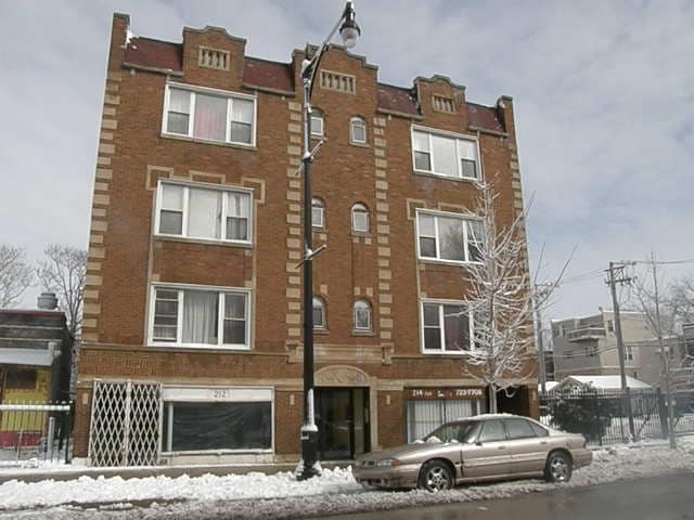
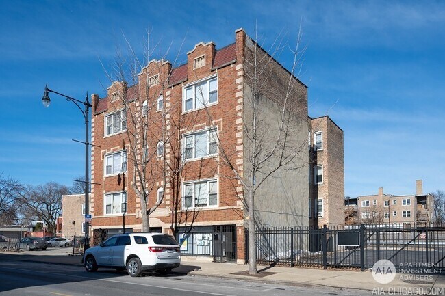
Property Record
212 E 71St St, Chicago, IL 60619
NEARBY LISTINGS FOR SALE OR LEASE
Property Detail
212 E 71St St
Chicago-Naperville-Elgin, IL-IN
Huff & Stovers
20-22-323-042-0000
(HUFF) & (STOVERS) SUB OF BLK 13 OF L C P FREERS SUB OF EH SW EX RR EH SW SEC 22-38-14
Commercialnec
Cook
X
Illinois
17031C0538K
28,29
2023
0.88 AC
2025
Greater Grand Crossing
690400
Chicago
9,760 SF
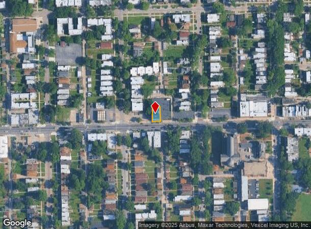
DEMOGRAPHICS near 212 E 71St St
1 mile
3 mile
5 mile
2024 Total Population
30,394
300,296
635,818
2029 Population
29,255
291,014
610,501
Pop Growth 2024-2029
(3.75%)
(3.09%)
(3.98%)
Average Age
38
39
39
2024 Total Households
12,203
127,797
251,381
HH Growth 2024-2029
(4.25%)
(3.39%)
(4.08%)
Median Household Inc
$30,098
$35,771
$41,018
Avg Household Size
2.40
2.20
2.40
2024 Avg HH Vehicles
1.00
1.00
1.00
Median Home Value
$175,880
$189,084
$191,051
Median Year Built
1947
1948
1949
Nearby Places
Map Layers
Map Styles
 Street
 Aerial
Transit
 Traffic
 Biking
Places
Listings with unknown addresses are not visible on the map
- Restaurants
- Banks
- Shops
- Fitness
- Groceries
PUBLIC TRANSPORTATION
TRANSIT/SUBWAY
69th Street Station (Red Line - Chicago Transit Authority "L" Trains (The "L"))
Drive
Walk
Distance
69th Street Station (Red Line - Chicago Transit Authority "L" Trains (The "L"))
4 min
11 min
0.6 mi
COMMUTER RAIL
75th Street (Grand Crossing) Station (Metra Electric Line - Northeast Illinois Regional Commuter Railroad (Metra))
Drive
Walk
Distance
75th Street (Grand Crossing) Station (Metra Electric Line - Northeast Illinois Regional Commuter Railroad (Metra))
4 min
1.6 mi
Stony Island Station (Metra Electric Line - Northeast Illinois Regional Commuter Railroad (Metra))
Drive
Walk
Distance
Stony Island Station (Metra Electric Line - Northeast Illinois Regional Commuter Railroad (Metra))
3 min
1.7 mi
AIRPORT
Chicago Midway International
Drive
Walk
Distance
Chicago Midway International
16 min
8.0 mi
Chicago O'Hare International
Drive
Walk
Distance
Chicago O'Hare International
63 min
28.9 mi
SALE & LEASE HISTORY
LISTING DATE
SALE/LEASE

Feb 27, 2025
For Sale
Nearby Properties
Address
Land Use
TOTAL SIZE
Lot Size
Zoning
Address
Land Use
TOTAL SIZE
Lot Size
Zoning
0.49 AC
SLI
Address
Land Use
TOTAL SIZE
Lot Size
Zoning
10.73 AC
PD 1243
Address
Land Use
TOTAL SIZE
Lot Size
Zoning
Address
Land Use
TOTAL SIZE
Lot Size
Zoning
0.28 AC
PD 38
Address
Land Use
TOTAL SIZE
Lot Size
Zoning
109,145 SF
0.46 AC
RM-5
Address
Land Use
TOTAL SIZE
Lot Size
Zoning
159,300 SF
13.36 AC
PD 425
Address
Land Use
TOTAL SIZE
Lot Size
Zoning
115,000 SF
1.97 AC
C1-2
Address
Land Use
TOTAL SIZE
Lot Size
Zoning
0.91 AC
PD 1177
Address
Land Use
TOTAL SIZE
Lot Size
Zoning
62,216 SF
0.65 AC
RM-5
Address
Land Use
TOTAL SIZE
Lot Size
Zoning
2.65 AC
PD 38
Address
Land Use
TOTAL SIZE
Lot Size
Zoning
304,685 SF
1.11 AC
PD 1218
Address
Land Use
TOTAL SIZE
Lot Size
Zoning
115,000 SF
1.12 AC
C1-2
Address
Land Use
TOTAL SIZE
Lot Size
Zoning
7,200 SF
0.22 AC
B3-3
Address
Land Use
TOTAL SIZE
Lot Size
Zoning
156,800 SF
2.65 AC
PD 38
Address
Land Use
TOTAL SIZE
Lot Size
Zoning
PD 43
Address
Land Use
TOTAL SIZE
Lot Size
Zoning
Address
Land Use
TOTAL SIZE
Lot Size
Zoning
451,349 SF
1.62 AC
PD 1062
Address
Land Use
TOTAL SIZE
Lot Size
Zoning
0.29 AC
PD 1548
Address
Land Use
TOTAL SIZE
Lot Size
Zoning
4,900 SF
0.29 AC
PD 1548
Address
Land Use
TOTAL SIZE
Lot Size
Zoning
0.39 AC
RM-6
Address
Land Use
TOTAL SIZE
Lot Size
Zoning
1.65 AC
B2-3
Address
Land Use
TOTAL SIZE
Lot Size
Zoning
PD 43
Address
Land Use
TOTAL SIZE
Lot Size
Zoning
769,600 SF
PD 282
Address
Land Use
TOTAL SIZE
Lot Size
Zoning
78,000 SF
0.62 AC
RM-5
Address
Land Use
TOTAL SIZE
Lot Size
Zoning
117,557 SF
2.69 AC
B3-3
Address
Land Use
TOTAL SIZE
Lot Size
Zoning
36,365 SF
Address
Land Use
TOTAL SIZE
Lot Size
Zoning
7.47 AC
RT-4
Address
Land Use
TOTAL SIZE
Lot Size
Zoning
0.84 AC
RM-5
Address
Land Use
TOTAL SIZE
Lot Size
Zoning
130,785 SF
2.27 AC
PD 1174
Address
Land Use
TOTAL SIZE
Lot Size
Zoning
156,249 SF
0.57 AC
B3-5
The World's #1 Commercial Real Estate Marketplace
Connect with us
© 2026 CoStar Group
The information above has been obtained from sources believed reliable. While we do not doubt its accuracy we have not verified it and make no guarantee, warranty or representation about it. It is your responsibility to independently confirm its accuracy and completeness. Any projections, opinions, assumptions, or estimates used are for example only and do not represent the current or future performance of the property. The value of this transaction to you depends on tax and other factors which should be evaluated by your tax, financial, and legal advisors. You and your advisors should conduct a careful, independent investigation of the property to determine to your satisfaction the suitability of the property for your needs.