Property Record
212 Carter Dr, Middletown, DE 19709


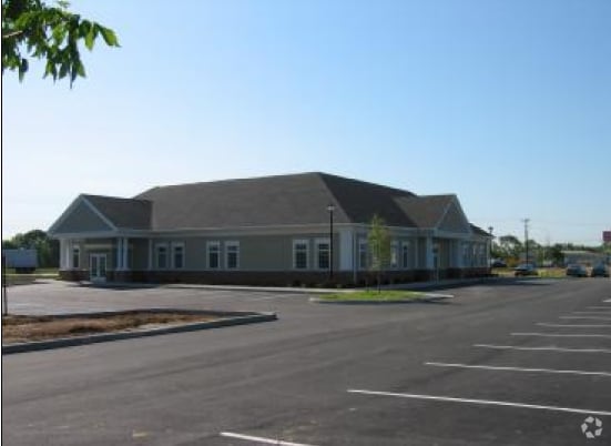

Property Detail
212 Carter Dr
23-032.00-094
New Castle
Medicalbuilding
Delaware
23R-1B
212
B and X Area of moderate flood hazard, usually the area between the limits of the 100-year and 500-year floods.
0.30 AC
2025
South New Castle County
2025
Philadelphia
016610
Philadelphia-Camden-Wilmington, PA-NJ-DE-MD
8,554 SF
NEARBY LISTINGS FOR SALE OR LEASE
DEMOGRAPHICS near 212 Carter Dr
1 mile
3 mile
5 mile
2025 Total Population
3,333
26,345
53,213
2030 Population
3,452
27,421
55,811
Pop Growth 2025-2030
+ 3.57%
+ 4.08%
+ 4.88%
Average Age
39
40
40
2025 Total Households
1,197
9,205
18,044
HH Growth 2025-2030
+ 3.34%
+ 4.15%
+ 5.02%
Median Household Inc
$95,538
$113,868
$130,741
Avg Household Size
2.80
2.80
2.90
2025 Avg HH Vehicles
2.00
2.00
2.00
Median Home Value
$390,109
$433,471
$467,882
Median Year Built
2004
2003
2005
Nearby Places
Map Layers
Map Styles
 Street
 Aerial
Layers
 Traffic
 Biking
Places
Listings with unknown addresses are not visible on the map
- Restaurants
- Banks
- Shops
- Fitness
- Groceries
PUBLIC TRANSPORTATION
AIRPORT
Philadelphia International
Drive
Walk
Distance
Philadelphia International
61 min
46.1 mi
Freight Ports
Port Newark Container Terminal
Drive
Walk
Distance
Port Newark Container Terminal
39 min
24.1 mi
SALE & LEASE HISTORY
LISTING DATE
SALE/LEASE

Sep 25, 2016
For Lease
Jan 06, 2017
For Lease
Nearby Properties
Address
Land Use
TOTAL SIZE
Lot Size
Zoning
Address
Land Use
TOTAL SIZE
Lot Size
Zoning
516,600 SF
66.26 AC
23M-I
Address
Land Use
TOTAL SIZE
Lot Size
Zoning
Address
Land Use
TOTAL SIZE
Lot Size
Zoning
Address
Land Use
TOTAL SIZE
Lot Size
Zoning
3,076 SF
26.98 AC
23M-I
Address
Land Use
TOTAL SIZE
Lot Size
Zoning
9,936 SF
61.99 AC
S
Address
Land Use
TOTAL SIZE
Lot Size
Zoning
135,477 SF
19.69 AC
23R-1A
Address
Land Use
TOTAL SIZE
Lot Size
Zoning
207,080 SF
25.03 AC
23C-3
Address
Land Use
TOTAL SIZE
Lot Size
Zoning
106.43 AC
23C-3
Address
Land Use
TOTAL SIZE
Lot Size
Zoning
404,730 SF
34.26 AC
23M-I
Address
Land Use
TOTAL SIZE
Lot Size
Zoning
190,704 SF
8.76 AC
23C-3
Address
Land Use
TOTAL SIZE
Lot Size
Zoning
Address
Land Use
TOTAL SIZE
Lot Size
Zoning
14,640 SF
10.32 AC
23R-3
Address
Land Use
TOTAL SIZE
Lot Size
Zoning
245,530 SF
15.47 AC
23M-I
Address
Land Use
TOTAL SIZE
Lot Size
Zoning
14,640 SF
9.05 AC
23R-3
Address
Land Use
TOTAL SIZE
Lot Size
Zoning
140,136 SF
15.11 AC
23C-3
Address
Land Use
TOTAL SIZE
Lot Size
Zoning
15,392 SF
23.55 AC
23C-3
Address
Land Use
TOTAL SIZE
Lot Size
Zoning
54,479 SF
13.09 AC
23C-3
Address
Land Use
TOTAL SIZE
Lot Size
Zoning
12.79 AC
23C-3
Address
Land Use
TOTAL SIZE
Lot Size
Zoning
5.95 AC
23C-3
Address
Land Use
TOTAL SIZE
Lot Size
Zoning
165.79 AC
23C-3
Address
Land Use
TOTAL SIZE
Lot Size
Zoning
3,600 SF
15.46 AC
23C-3
Address
Land Use
TOTAL SIZE
Lot Size
Zoning
6.50 AC
23C-3
Address
Land Use
TOTAL SIZE
Lot Size
Zoning
26,203 SF
22.03 AC
23C-3
Address
Land Use
TOTAL SIZE
Lot Size
Zoning
2,040 SF
66 AC
23C-3
Address
Land Use
TOTAL SIZE
Lot Size
Zoning
2,759 SF
106.44 AC
23M-I
Address
Land Use
TOTAL SIZE
Lot Size
Zoning
114,400 SF
16.16 AC
23M-I
Address
Land Use
TOTAL SIZE
Lot Size
Zoning
48,857 SF
6.57 AC
23C-2
Address
Land Use
TOTAL SIZE
Lot Size
Zoning
27,411 SF
11.33 AC
23C-3
Address
Land Use
TOTAL SIZE
Lot Size
Zoning
2,976 SF
16.05 AC
23R-1A
Address
Land Use
TOTAL SIZE
Lot Size
Zoning
8,240 SF
10.81 AC
23C-3
The World's #1 Commercial Real Estate Marketplace
Connect with us
© 2026 CoStar Group
The information above has been obtained from sources believed reliable. While we do not doubt its accuracy we have not verified it and make no guarantee, warranty or representation about it. It is your responsibility to independently confirm its accuracy and completeness. Any projections, opinions, assumptions, or estimates used are for example only and do not represent the current or future performance of the property. The value of this transaction to you depends on tax and other factors which should be evaluated by your tax, financial, and legal advisors. You and your advisors should conduct a careful, independent investigation of the property to determine to your satisfaction the suitability of the property for your needs.