Property Record
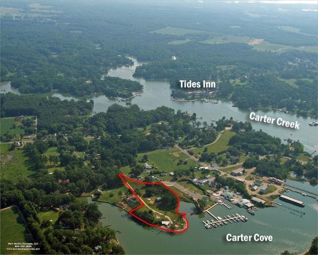
212 Carters Cove Dr, Weems, VA 22576

Property Detail
212 Carters Cove Dr
33-164
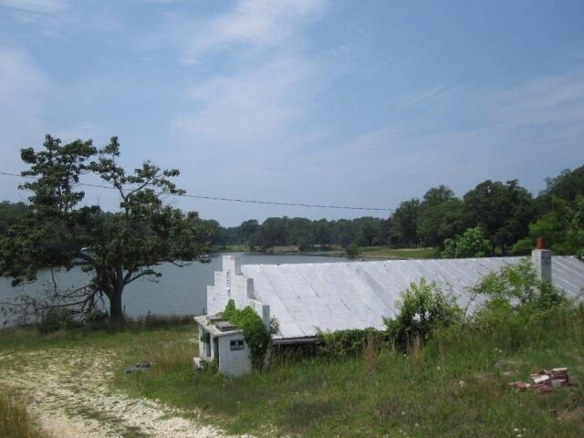
JOHN NECK 4.892 AC POND .245 AC INCLU LR22/1033
Governmentalpublicusegeneral
Lancaster
M1
Virginia
AE The base floodplain where base flood elevations are provided. AE Zones are now used on new format FIRMs instead of A1-A30 Zones.
4.89 AC
2025
Virginia Regional
2025
Other Market Areas
030302
NEARBY LISTINGS FOR SALE OR LEASE
-
-
View all Weems listings for sale on LoopNet.com
DEMOGRAPHICS near 212 Carters Cove Dr
1 mile
3 mile
5 mile
2025 Total Population
601
2,788
7,250
2030 Population
594
2,783
7,341
Pop Growth 2025-2030
(1.16%)
(0.18%)
+ 1.26%
Average Age
54
54
52
2025 Total Households
302
1,373
3,496
HH Growth 2025-2030
(0.99%)
(0.36%)
+ 1.23%
Median Household Inc
$73,557
$67,854
$65,763
Avg Household Size
2.00
1.90
2.00
2025 Avg HH Vehicles
2.00
2.00
2.00
Median Home Value
$478,124
$403,896
$374,034
Median Year Built
1978
1980
1981
Nearby Places
Map Layers
Map Styles
 Street
 Aerial
Layers
 Traffic
 Biking
Places
Listings with unknown addresses are not visible on the map
- Restaurants
- Banks
- Shops
- Fitness
- Groceries
Nearby Properties
Address
Land Use
TOTAL SIZE
Lot Size
Zoning
Address
Land Use
TOTAL SIZE
Lot Size
Zoning
294,046 SF
23.66 AC
R1
Address
Land Use
TOTAL SIZE
Lot Size
Zoning
28,886 SF
22.65 AC
C1
Address
Land Use
TOTAL SIZE
Lot Size
Zoning
3,590 SF
6 AC
R1
Address
Land Use
TOTAL SIZE
Lot Size
Zoning
10,458 SF
340.46 AC
R2
Address
Land Use
TOTAL SIZE
Lot Size
Zoning
22,775 SF
6.62 AC
C1
Address
Land Use
TOTAL SIZE
Lot Size
Zoning
5,451 SF
0.74 AC
C1
Address
Land Use
TOTAL SIZE
Lot Size
Zoning
12,356 SF
2.17 AC
R1
Address
Land Use
TOTAL SIZE
Lot Size
Zoning
2,250 SF
2.27 AC
R1
Address
Land Use
TOTAL SIZE
Lot Size
Zoning
15,820 SF
2.06 AC
M1
Address
Land Use
TOTAL SIZE
Lot Size
Zoning
8,372 SF
0.99 AC
C1
Address
Land Use
TOTAL SIZE
Lot Size
Zoning
20,400 SF
1.40 AC
R1
Address
Land Use
TOTAL SIZE
Lot Size
Zoning
10,402 SF
3.84 AC
C1
Address
Land Use
TOTAL SIZE
Lot Size
Zoning
3,315 SF
8.20 AC
R1
Address
Land Use
TOTAL SIZE
Lot Size
Zoning
5,450 SF
3.72 AC
A2
Address
Land Use
TOTAL SIZE
Lot Size
Zoning
15,764 SF
11.57 AC
A2
Address
Land Use
TOTAL SIZE
Lot Size
Zoning
4,112 SF
0.98 AC
C1
Address
Land Use
TOTAL SIZE
Lot Size
Zoning
9,100 SF
3.11 AC
C1
Address
Land Use
TOTAL SIZE
Lot Size
Zoning
5,184 SF
4.13 AC
R1
Address
Land Use
TOTAL SIZE
Lot Size
Zoning
2,217 SF
4.24 AC
R1
Address
Land Use
TOTAL SIZE
Lot Size
Zoning
9,168 SF
2.88 AC
C1
Address
Land Use
TOTAL SIZE
Lot Size
Zoning
4,095 SF
0.67 AC
C1
Address
Land Use
TOTAL SIZE
Lot Size
Zoning
8,920 SF
4.42 AC
CR
Address
Land Use
TOTAL SIZE
Lot Size
Zoning
11,700 SF
5.01 AC
A2
Address
Land Use
TOTAL SIZE
Lot Size
Zoning
2,227 SF
12.20 AC
C1
Address
Land Use
TOTAL SIZE
Lot Size
Zoning
2,180 SF
1.97 AC
H1
Address
Land Use
TOTAL SIZE
Lot Size
Zoning
7.84 AC
M1
Address
Land Use
TOTAL SIZE
Lot Size
Zoning
4,624 SF
2.91 AC
C1
Address
Land Use
TOTAL SIZE
Lot Size
Zoning
4,124 SF
0.36 AC
C1
Address
Land Use
TOTAL SIZE
Lot Size
Zoning
2,368 SF
2.84 AC
C1
Address
Land Use
TOTAL SIZE
Lot Size
Zoning
5,316 SF
0.58 AC
R1
The World's #1 Commercial Real Estate Marketplace
Connect with us
© 2026 CoStar Group
The information above has been obtained from sources believed reliable. While we do not doubt its accuracy we have not verified it and make no guarantee, warranty or representation about it. It is your responsibility to independently confirm its accuracy and completeness. Any projections, opinions, assumptions, or estimates used are for example only and do not represent the current or future performance of the property. The value of this transaction to you depends on tax and other factors which should be evaluated by your tax, financial, and legal advisors. You and your advisors should conduct a careful, independent investigation of the property to determine to your satisfaction the suitability of the property for your needs.