Property Record
212 E Davilla St, Granger, TX 76530
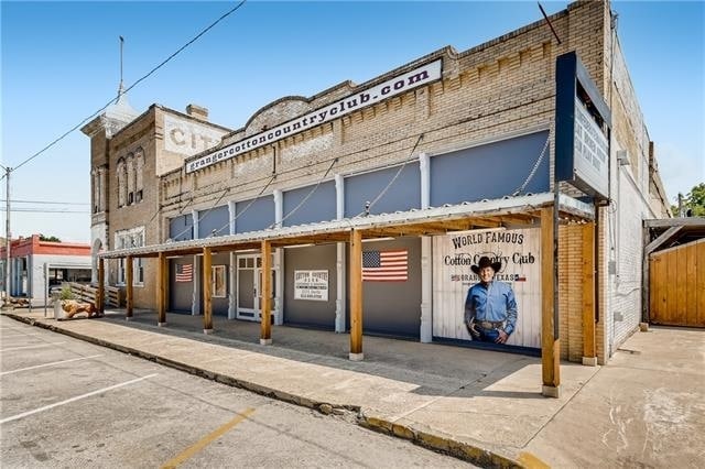


Property Detail
212 E Davilla St
Austin-Round Rock-San Marcos, TX
S3688 - GRANGER CITY OF, BLOCK 17, LOT 15 (E/PT) & 16-19, ACRES 0.449
R013752
WILLIAMSON
Commercialnec
Texas
B and X Area of moderate flood hazard, usually the area between the limits of the 100-year and 500-year floods.
15
2024
0.45 AC
2025
Georgetown
021300
Austin
8,856 SF
NEARBY LISTINGS FOR SALE OR LEASE
-
-
View all Granger listings for sale on LoopNet.com
DEMOGRAPHICS near 212 E Davilla St
1 mile
3 mile
5 mile
2025 Total Population
1,548
1,805
2,565
2030 Population
1,774
2,065
2,921
Pop Growth 2025-2030
+ 14.60%
+ 14.40%
+ 13.88%
Average Age
41
41
42
2025 Total Households
632
732
1,029
HH Growth 2025-2030
+ 14.87%
+ 14.75%
+ 14.29%
Median Household Inc
$58,809
$62,528
$73,332
Avg Household Size
2.50
2.50
2.50
2025 Avg HH Vehicles
2.00
2.00
2.00
Median Home Value
$135,555
$156,597
$235,802
Median Year Built
1974
1977
1984
Nearby Places
Map Layers
Map Styles
 Street
 Aerial
Transit
 Traffic
 Biking
Places
Listings with unknown addresses are not visible on the map
- Restaurants
- Banks
- Shops
- Fitness
- Groceries
PUBLIC TRANSPORTATION
AIRPORT
Killeen Municipal
Drive
Walk
Distance
Killeen Municipal
56 min
38.5 mi
Robert Gray AAF
Drive
Walk
Distance
Robert Gray AAF
69 min
46.8 mi
SALE & LEASE HISTORY
LISTING DATE
SALE/LEASE

Oct 05, 2021
For Sale
Nov 12, 2021
For Sale
Jun 23, 2022
For Sale
Nearby Properties
Address
Land Use
TOTAL SIZE
Lot Size
Zoning
Address
Land Use
TOTAL SIZE
Lot Size
Zoning
73,294 SF
42.47 AC
Address
Land Use
TOTAL SIZE
Lot Size
Zoning
87 SF
10.46 AC
Address
Land Use
TOTAL SIZE
Lot Size
Zoning
3,304 SF
10.91 AC
Address
Land Use
TOTAL SIZE
Lot Size
Zoning
53,321 SF
1.93 AC
Address
Land Use
TOTAL SIZE
Lot Size
Zoning
25,887 SF
2.07 AC
Address
Land Use
TOTAL SIZE
Lot Size
Zoning
15,832 SF
10.08 AC
Address
Land Use
TOTAL SIZE
Lot Size
Zoning
542.10 AC
Address
Land Use
TOTAL SIZE
Lot Size
Zoning
10,780 SF
2 AC
Address
Land Use
TOTAL SIZE
Lot Size
Zoning
2,774 SF
3.13 AC
Address
Land Use
TOTAL SIZE
Lot Size
Zoning
24,385 SF
1.93 AC
Address
Land Use
TOTAL SIZE
Lot Size
Zoning
17,436 SF
6.32 AC
Address
Land Use
TOTAL SIZE
Lot Size
Zoning
44,740 SF
1.74 AC
Address
Land Use
TOTAL SIZE
Lot Size
Zoning
375.30 AC
Address
Land Use
TOTAL SIZE
Lot Size
Zoning
33.12 AC
Address
Land Use
TOTAL SIZE
Lot Size
Zoning
2,170 SF
0.45 AC
Address
Land Use
TOTAL SIZE
Lot Size
Zoning
4,968 SF
28.50 AC
Address
Land Use
TOTAL SIZE
Lot Size
Zoning
3,430 SF
0.25 AC
Address
Land Use
TOTAL SIZE
Lot Size
Zoning
20,300 SF
0.90 AC
Address
Land Use
TOTAL SIZE
Lot Size
Zoning
3,800 SF
0.57 AC
Address
Land Use
TOTAL SIZE
Lot Size
Zoning
2,749 SF
12 AC
Address
Land Use
TOTAL SIZE
Lot Size
Zoning
28,815 SF
2.07 AC
Address
Land Use
TOTAL SIZE
Lot Size
Zoning
6.44 AC
Address
Land Use
TOTAL SIZE
Lot Size
Zoning
10,981 SF
4.93 AC
Address
Land Use
TOTAL SIZE
Lot Size
Zoning
38.34 AC
Address
Land Use
TOTAL SIZE
Lot Size
Zoning
2,783 SF
36.72 AC
Address
Land Use
TOTAL SIZE
Lot Size
Zoning
2,500 SF
0.22 AC
Address
Land Use
TOTAL SIZE
Lot Size
Zoning
3,283 SF
4.60 AC
Address
Land Use
TOTAL SIZE
Lot Size
Zoning
5,904 SF
0.13 AC
Address
Land Use
TOTAL SIZE
Lot Size
Zoning
169 AC
The World's #1 Commercial Real Estate Marketplace
Connect with us
© 2026 CoStar Group
The information above has been obtained from sources believed reliable. While we do not doubt its accuracy we have not verified it and make no guarantee, warranty or representation about it. It is your responsibility to independently confirm its accuracy and completeness. Any projections, opinions, assumptions, or estimates used are for example only and do not represent the current or future performance of the property. The value of this transaction to you depends on tax and other factors which should be evaluated by your tax, financial, and legal advisors. You and your advisors should conduct a careful, independent investigation of the property to determine to your satisfaction the suitability of the property for your needs.