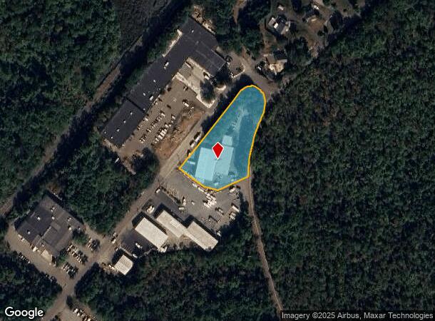
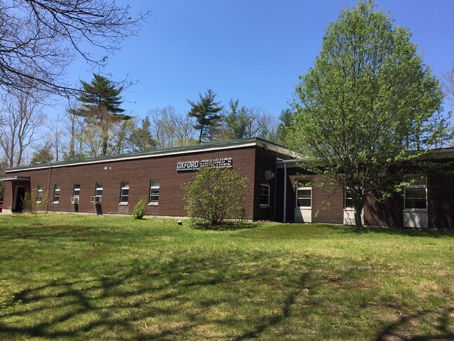
Property Record
212 Magnolia Ave, Gloucester, MA 01930


NEARBY LISTINGS FOR SALE OR LEASE
-
-
View all Gloucester listings for sale on LoopNet.com
Property Detail
212 Magnolia Ave
Manufacturinglight
Essex
X
Massachusetts
25009C0451H
1.71 AC
2025
Essex/Gloucester
2025
Boston
221901
Boston-Cambridge-Newton, MA-NH
16,799 SF
GLOU-000207-000031
DEMOGRAPHICS near 212 Magnolia Ave
1 Mile
3 Mile
5 Mile
2024 Total Population
780
15,332
38,960
2029 Population
778
15,331
39,058
Pop Growth 2024-2029
(0.26%)
(0.01%)
+ 0.25%
Average Age
46
45
45
2024 Total Households
311
6,556
16,772
HH Growth 2024-2029
(0.32%)
(0.20%)
+ 0.10%
Median Household Inc
$111,778
$99,660
$96,730
Avg Household Size
2.50
2.30
2.30
2024 Avg HH Vehicles
2.00
2.00
2.00
Median Home Value
$676,751
$647,451
$668,585
Median Year Built
1973
1957
1953
Nearby Places
Map Layers
Map Styles
 Street
 Aerial
- Restaurants
- Banks
- Shops
- Fitness
- Groceries
PUBLIC TRANSPORTATION
COMMUTER RAIL
West Gloucester (Newburyport/Rockport Line - Massachusetts Bay Transportation Authority Commuter Rail (Purple Line))
DRIVE
WALK
Distance
West Gloucester (Newburyport/Rockport Line - Massachusetts Bay Transportation Authority Commuter Rail (Purple Line))
3 min
1.5 mi
Manchester (Newburyport/Rockport Line - Massachusetts Bay Transportation Authority Commuter Rail (Purple Line))
DRIVE
WALK
Distance
Manchester (Newburyport/Rockport Line - Massachusetts Bay Transportation Authority Commuter Rail (Purple Line))
10 min
4.6 mi
AIRPORT
General Edward Lawrence Logan International
DRIVE
WALK
Distance
General Edward Lawrence Logan International
51 min
29.9 mi
Freight Ports
Port of Boston
DRIVE
WALK
Distance
Port of Boston
56 min
36.9 mi
SALE & LEASE HISTORY
LISTING DATE
SALE/LEASE

Sep 24, 2016
For Sale
Nearby Properties
Address
Land Use
TOTAL SIZE
Lot Size
Zoning
Address
Land Use
TOTAL SIZE
Lot Size
Zoning
246,863 SF
18.84 AC
R-20
Address
Land Use
TOTAL SIZE
Lot Size
Zoning
184,976 SF
7.13 AC
A
Address
Land Use
TOTAL SIZE
Lot Size
Zoning
11,513 SF
17.50 AC
R-20
Address
Land Use
TOTAL SIZE
Lot Size
Zoning
180.40 AC
A
Address
Land Use
TOTAL SIZE
Lot Size
Zoning
60,000 SF
9.91 AC
R-10
Address
Land Use
TOTAL SIZE
Lot Size
Zoning
1,834 SF
23.45 AC
R-10
Address
Land Use
TOTAL SIZE
Lot Size
Zoning
67,972 SF
20.94 AC
R-20
Address
Land Use
TOTAL SIZE
Lot Size
Zoning
91,450 SF
11.31 AC
G
Address
Land Use
TOTAL SIZE
Lot Size
Zoning
85,464 SF
1.85 AC
MI
Address
Land Use
TOTAL SIZE
Lot Size
Zoning
7,801 SF
2.76 AC
E
Address
Land Use
TOTAL SIZE
Lot Size
Zoning
1.69 AC
E
Address
Land Use
TOTAL SIZE
Lot Size
Zoning
14,042 SF
12 AC
R-20
Address
Land Use
TOTAL SIZE
Lot Size
Zoning
14,914 SF
2.25 AC
RC-40
Address
Land Use
TOTAL SIZE
Lot Size
Zoning
1.34 AC
E
Address
Land Use
TOTAL SIZE
Lot Size
Zoning
1.80 AC
E
Address
Land Use
TOTAL SIZE
Lot Size
Zoning
1,557 SF
598 AC
R-30
Address
Land Use
TOTAL SIZE
Lot Size
Zoning
2.28 AC
E
Address
Land Use
TOTAL SIZE
Lot Size
Zoning
61 AC
R-20
Address
Land Use
TOTAL SIZE
Lot Size
Zoning
41.14 AC
LCD
Address
Land Use
TOTAL SIZE
Lot Size
Zoning
86,343 SF
6.36 AC
LCD
Address
Land Use
TOTAL SIZE
Lot Size
Zoning
12.20 AC
E
Address
Land Use
TOTAL SIZE
Lot Size
Zoning
6.79 AC
RC-40
Address
Land Use
TOTAL SIZE
Lot Size
Zoning
23.96 AC
E
Address
Land Use
TOTAL SIZE
Lot Size
Zoning
51,790 SF
4.10 AC
R-10
Address
Land Use
TOTAL SIZE
Lot Size
Zoning
7,879 SF
2.95 AC
E
Address
Land Use
TOTAL SIZE
Lot Size
Zoning
2,718 SF
1.29 AC
E
Address
Land Use
TOTAL SIZE
Lot Size
Zoning
684 SF
1.18 AC
E
Address
Land Use
TOTAL SIZE
Lot Size
Zoning
9.74 AC
EB
Address
Land Use
TOTAL SIZE
Lot Size
Zoning
4,938 SF
3.50 AC
E
Address
Land Use
TOTAL SIZE
Lot Size
Zoning
2.07 AC
E
The World's #1 Commercial Real Estate Marketplace
Connect with us
© 2025 CoStar Group
The information above has been obtained from sources believed reliable. While we do not doubt its accuracy we have not verified it and make no guarantee, warranty or representation about it. It is your responsibility to independently confirm its accuracy and completeness. Any projections, opinions, assumptions, or estimates used are for example only and do not represent the current or future performance of the property. The value of this transaction to you depends on tax and other factors which should be evaluated by your tax, financial, and legal advisors. You and your advisors should conduct a careful, independent investigation of the property to determine to your satisfaction the suitability of the property for your needs.