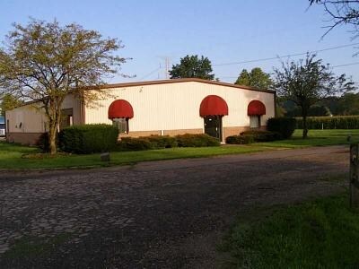
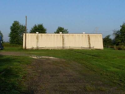
Property Record
212 N Main St, Maxwell, IN 46154

NEARBY LISTINGS FOR SALE OR LEASE
Property Detail
212 N Main St
30-07-05-400-021.000-008
E SE 5-16-7 1.5AC
Parkingstructure
Hancock
X
Indiana
18059C0132D
2.33 AC
2024
Hancock County
2024
Indianapolis
410301
Indianapolis-Carmel-Anderson, IN
3,800 SF
DEMOGRAPHICS near 212 N Main St
1 Mile
3 Mile
5 Mile
2024 Total Population
656
3,741
19,335
2029 Population
712
4,071
21,312
Pop Growth 2024-2029
+ 8.54%
+ 8.82%
+ 10.22%
Average Age
40
42
41
2024 Total Households
258
1,473
7,794
HH Growth 2024-2029
+ 8.91%
+ 9.16%
+ 10.59%
Median Household Inc
$70,714
$71,515
$75,665
Avg Household Size
2.50
2.50
2.40
2024 Avg HH Vehicles
2.00
3.00
2.00
Median Home Value
$196,720
$227,612
$185,643
Median Year Built
1985
1978
1989
Nearby Places
Map Layers
Map Styles
 Street
 Aerial
- Restaurants
- Banks
- Shops
- Fitness
- Groceries
PUBLIC TRANSPORTATION
AIRPORT
Indianapolis International
DRIVE
WALK
Distance
Indianapolis International
58 min
39.0 mi
Nearby Properties
Address
Land Use
TOTAL SIZE
Lot Size
Zoning
Address
Land Use
TOTAL SIZE
Lot Size
Zoning
26,680 SF
20.64 AC
Address
Land Use
TOTAL SIZE
Lot Size
Zoning
704 SF
41.46 AC
Address
Land Use
TOTAL SIZE
Lot Size
Zoning
49,600 SF
4.27 AC
Address
Land Use
TOTAL SIZE
Lot Size
Zoning
5,805 SF
17.77 AC
Address
Land Use
TOTAL SIZE
Lot Size
Zoning
46,690 SF
2.08 AC
Address
Land Use
TOTAL SIZE
Lot Size
Zoning
46,772 SF
1.21 AC
Address
Land Use
TOTAL SIZE
Lot Size
Zoning
46,680 SF
1.96 AC
Address
Land Use
TOTAL SIZE
Lot Size
Zoning
18,000 SF
15.12 AC
Address
Land Use
TOTAL SIZE
Lot Size
Zoning
Address
Land Use
TOTAL SIZE
Lot Size
Zoning
3,514 SF
19.46 AC
Address
Land Use
TOTAL SIZE
Lot Size
Zoning
30,662 SF
25 AC
Address
Land Use
TOTAL SIZE
Lot Size
Zoning
10,062 SF
2.64 AC
Address
Land Use
TOTAL SIZE
Lot Size
Zoning
52,704 SF
3.29 AC
Address
Land Use
TOTAL SIZE
Lot Size
Zoning
6,641 SF
2.19 AC
Address
Land Use
TOTAL SIZE
Lot Size
Zoning
2,464 SF
22.19 AC
Address
Land Use
TOTAL SIZE
Lot Size
Zoning
13,678 SF
1.53 AC
Address
Land Use
TOTAL SIZE
Lot Size
Zoning
3,423 SF
0.81 AC
Address
Land Use
TOTAL SIZE
Lot Size
Zoning
8.04 AC
Address
Land Use
TOTAL SIZE
Lot Size
Zoning
3.33 AC
Address
Land Use
TOTAL SIZE
Lot Size
Zoning
4,312 SF
1.35 AC
Address
Land Use
TOTAL SIZE
Lot Size
Zoning
9.77 AC
Address
Land Use
TOTAL SIZE
Lot Size
Zoning
6.01 AC
Address
Land Use
TOTAL SIZE
Lot Size
Zoning
4,120 SF
8.05 AC
Address
Land Use
TOTAL SIZE
Lot Size
Zoning
560 SF
8.91 AC
Address
Land Use
TOTAL SIZE
Lot Size
Zoning
1.37 AC
Address
Land Use
TOTAL SIZE
Lot Size
Zoning
3,360 SF
102.43 AC
Address
Land Use
TOTAL SIZE
Lot Size
Zoning
41.91 AC
Address
Land Use
TOTAL SIZE
Lot Size
Zoning
3.43 AC
Address
Land Use
TOTAL SIZE
Lot Size
Zoning
144.97 AC
The World's #1 Commercial Real Estate Marketplace
Connect with us
© 2026 CoStar Group
The information above has been obtained from sources believed reliable. While we do not doubt its accuracy we have not verified it and make no guarantee, warranty or representation about it. It is your responsibility to independently confirm its accuracy and completeness. Any projections, opinions, assumptions, or estimates used are for example only and do not represent the current or future performance of the property. The value of this transaction to you depends on tax and other factors which should be evaluated by your tax, financial, and legal advisors. You and your advisors should conduct a careful, independent investigation of the property to determine to your satisfaction the suitability of the property for your needs.