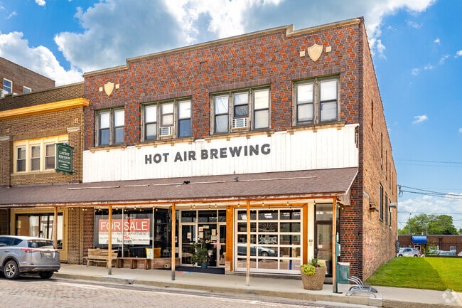
Property Record
212 N Maple St, Creston, IA 50801

Property Detail
212 N Maple St
0501457009
OP COLBY & HOLMAN'S SUB-DIV LOTS 218-219-220 LOT 7
Bartavern
UNION
B and X Area of moderate flood hazard, usually the area between the limits of the 100-year and 500-year floods.
Iowa
2025
7
2025
0.12 AC
190200
Iowa West Area
10,494 SF
Other Market Areas
NEARBY LISTINGS FOR SALE OR LEASE
DEMOGRAPHICS near 212 N Maple St
1 mile
3 mile
5 mile
2025 Total Population
6,351
8,008
8,282
2030 Population
6,308
7,938
8,204
Pop Growth 2025-2030
(0.68%)
(0.87%)
(0.94%)
Average Age
41
41
42
2025 Total Households
2,791
3,479
3,585
HH Growth 2025-2030
(0.68%)
(0.89%)
(0.95%)
Median Household Inc
$48,518
$52,687
$53,470
Avg Household Size
2.10
2.10
2.10
2025 Avg HH Vehicles
2.00
2.00
2.00
Median Home Value
$111,620
$126,474
$129,253
Median Year Built
1953
1957
1957
Nearby Places
Map Layers
Map Styles
 Street
 Aerial
Layers
 Traffic
 Biking
Places
Listings with unknown addresses are not visible on the map
- Restaurants
- Banks
- Shops
- Fitness
- Groceries
PUBLIC TRANSPORTATION
COMMUTER RAIL
Creston Amtrak (California Zephyr - Amtrak)
Drive
Walk
Distance
Creston Amtrak (California Zephyr - Amtrak)
0 min
3 min
0.2 mi
Freight Ports
Tulsa Port Of Catoosa
Drive
Walk
Distance
Tulsa Port Of Catoosa
467 min
396.4 mi
SALE & LEASE HISTORY
LISTING DATE
SALE/LEASE

Aug 27, 2025
For Sale
Nearby Properties
Address
Land Use
TOTAL SIZE
Lot Size
Zoning
Address
Land Use
TOTAL SIZE
Lot Size
Zoning
9,316 SF
47.90 AC
Address
Land Use
TOTAL SIZE
Lot Size
Zoning
151,620 SF
21.13 AC
Address
Land Use
TOTAL SIZE
Lot Size
Zoning
1,080 SF
39.75 AC
Address
Land Use
TOTAL SIZE
Lot Size
Zoning
159,175 SF
21.14 AC
Address
Land Use
TOTAL SIZE
Lot Size
Zoning
1,776 SF
10.78 AC
Address
Land Use
TOTAL SIZE
Lot Size
Zoning
10,880 SF
35.67 AC
Address
Land Use
TOTAL SIZE
Lot Size
Zoning
77,046 SF
9.50 AC
Address
Land Use
TOTAL SIZE
Lot Size
Zoning
640 SF
2.79 AC
Address
Land Use
TOTAL SIZE
Lot Size
Zoning
15,106 SF
3 AC
Address
Land Use
TOTAL SIZE
Lot Size
Zoning
28,798 SF
3.71 AC
Address
Land Use
TOTAL SIZE
Lot Size
Zoning
34,252 SF
42.50 AC
Address
Land Use
TOTAL SIZE
Lot Size
Zoning
228,750 SF
12.69 AC
Address
Land Use
TOTAL SIZE
Lot Size
Zoning
19,444 SF
2.41 AC
Address
Land Use
TOTAL SIZE
Lot Size
Zoning
4,900 SF
1.50 AC
Address
Land Use
TOTAL SIZE
Lot Size
Zoning
34,450 SF
3.06 AC
Address
Land Use
TOTAL SIZE
Lot Size
Zoning
28,546 SF
0.67 AC
Address
Land Use
TOTAL SIZE
Lot Size
Zoning
151,184 SF
9.31 AC
Address
Land Use
TOTAL SIZE
Lot Size
Zoning
19,178 SF
1.34 AC
Address
Land Use
TOTAL SIZE
Lot Size
Zoning
66,392 SF
10 AC
Address
Land Use
TOTAL SIZE
Lot Size
Zoning
4,925 SF
1.43 AC
Address
Land Use
TOTAL SIZE
Lot Size
Zoning
4,494 SF
1.04 AC
Address
Land Use
TOTAL SIZE
Lot Size
Zoning
3,480 SF
1.74 AC
Address
Land Use
TOTAL SIZE
Lot Size
Zoning
9,908 SF
4.49 AC
Address
Land Use
TOTAL SIZE
Lot Size
Zoning
2,880 SF
6.21 AC
Address
Land Use
TOTAL SIZE
Lot Size
Zoning
7,348 SF
0.43 AC
Address
Land Use
TOTAL SIZE
Lot Size
Zoning
8,000 SF
1.54 AC
Address
Land Use
TOTAL SIZE
Lot Size
Zoning
14,000 SF
17.39 AC
Address
Land Use
TOTAL SIZE
Lot Size
Zoning
3,632 SF
2.85 AC
Address
Land Use
TOTAL SIZE
Lot Size
Zoning
20,461 SF
1.95 AC
Address
Land Use
TOTAL SIZE
Lot Size
Zoning
18,800 SF
10.19 AC
The World's #1 Commercial Real Estate Marketplace
Connect with us
© 2026 CoStar Group
The information above has been obtained from sources believed reliable. While we do not doubt its accuracy we have not verified it and make no guarantee, warranty or representation about it. It is your responsibility to independently confirm its accuracy and completeness. Any projections, opinions, assumptions, or estimates used are for example only and do not represent the current or future performance of the property. The value of this transaction to you depends on tax and other factors which should be evaluated by your tax, financial, and legal advisors. You and your advisors should conduct a careful, independent investigation of the property to determine to your satisfaction the suitability of the property for your needs.