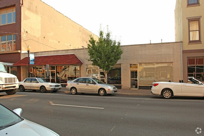
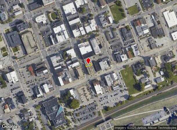
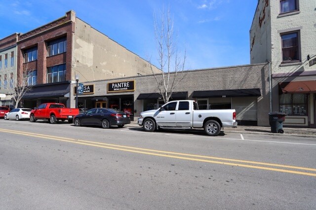
Property Record
212 Pearl St, New Albany, IN 47150
NEARBY LISTINGS FOR SALE OR LEASE
Property Detail
212 Pearl St
22-05-00-200-194.000-008
P 93 PRT L 10, P 93 PRT L 13 #27 P.93 PRT L13 #28;PRT L.12/13 #23 P.93 PRT L.12 & 13 008-78101-43 TIF
Storebuilding
Floyd
X
Indiana
21111C0011F
0.15 AC
2024
New Albany
2024
Louisville
070500
Louisville-Jefferson County, KY-IN
6,114 SF
DEMOGRAPHICS near 212 Pearl St
1 Mile
3 Mile
5 Mile
2024 Total Population
7,788
70,433
158,272
2029 Population
7,971
71,482
161,900
Pop Growth 2024-2029
+ 2.35%
+ 1.49%
+ 2.29%
Average Age
39
40
40
2024 Total Households
3,417
29,737
67,710
HH Growth 2024-2029
+ 2.52%
+ 1.44%
+ 2.43%
Median Household Inc
$44,213
$40,180
$39,368
Avg Household Size
2.10
2.30
2.20
2024 Avg HH Vehicles
2.00
1.00
1.00
Median Home Value
$127,818
$120,207
$133,738
Median Year Built
1947
1949
1957
Nearby Places
Map Layers
Map Styles
 Street
 Aerial
- Restaurants
- Banks
- Shops
- Fitness
- Groceries
PUBLIC TRANSPORTATION
AIRPORT
Louisville Muhammad Ali International
DRIVE
WALK
Distance
Louisville Muhammad Ali International
22 min
12.4 mi
SALE & LEASE HISTORY
LISTING DATE
SALE/LEASE

Mar 23, 2020
For Lease
Jan 23, 2025
For Lease
Apr 04, 2024
For Lease
Nearby Properties
Address
Land Use
TOTAL SIZE
Lot Size
Zoning
Address
Land Use
TOTAL SIZE
Lot Size
Zoning
95,508 SF
3.67 AC
EZ1-ENTERP
Address
Land Use
TOTAL SIZE
Lot Size
Zoning
175,626 SF
60.10 AC
Address
Land Use
TOTAL SIZE
Lot Size
Zoning
12,270 SF
13.50 AC
Address
Land Use
TOTAL SIZE
Lot Size
Zoning
25,728 SF
10.37 AC
Address
Land Use
TOTAL SIZE
Lot Size
Zoning
3,692 SF
15.99 AC
Address
Land Use
TOTAL SIZE
Lot Size
Zoning
143,700 SF
0.29 AC
Address
Land Use
TOTAL SIZE
Lot Size
Zoning
202,859 SF
22.95 AC
Address
Land Use
TOTAL SIZE
Lot Size
Zoning
14,355 SF
1.50 AC
C2-COMMERC
Address
Land Use
TOTAL SIZE
Lot Size
Zoning
34,308 SF
4.59 AC
Address
Land Use
TOTAL SIZE
Lot Size
Zoning
72,332 SF
2.48 AC
Address
Land Use
TOTAL SIZE
Lot Size
Zoning
83,084 SF
14.65 AC
Address
Land Use
TOTAL SIZE
Lot Size
Zoning
67,600 SF
6.76 AC
EZ1-ENTERP
Address
Land Use
TOTAL SIZE
Lot Size
Zoning
60,371 SF
1.54 AC
EZ1-ENTERP
Address
Land Use
TOTAL SIZE
Lot Size
Zoning
272 SF
210.55 AC
Address
Land Use
TOTAL SIZE
Lot Size
Zoning
26,016 SF
6.62 AC
EZ1-ENTERP
Address
Land Use
TOTAL SIZE
Lot Size
Zoning
35,044 SF
3.39 AC
Address
Land Use
TOTAL SIZE
Lot Size
Zoning
44,380 SF
3.85 AC
EZ1-ENTERP
Address
Land Use
TOTAL SIZE
Lot Size
Zoning
118,371 SF
11.83 AC
Address
Land Use
TOTAL SIZE
Lot Size
Zoning
75,310 SF
0.83 AC
Address
Land Use
TOTAL SIZE
Lot Size
Zoning
7,496 SF
9.37 AC
Address
Land Use
TOTAL SIZE
Lot Size
Zoning
16,088 SF
8.13 AC
Address
Land Use
TOTAL SIZE
Lot Size
Zoning
65,748 SF
4.34 AC
Address
Land Use
TOTAL SIZE
Lot Size
Zoning
59,998 SF
7.28 AC
Address
Land Use
TOTAL SIZE
Lot Size
Zoning
26,532 SF
1.20 AC
Address
Land Use
TOTAL SIZE
Lot Size
Zoning
29,354 SF
2.98 AC
R5-RESIDEN
Address
Land Use
TOTAL SIZE
Lot Size
Zoning
75,898 SF
2.16 AC
Address
Land Use
TOTAL SIZE
Lot Size
Zoning
301,104 SF
15.74 AC
Address
Land Use
TOTAL SIZE
Lot Size
Zoning
1,758 SF
10.41 AC
Address
Land Use
TOTAL SIZE
Lot Size
Zoning
48,490 SF
0.28 AC
Address
Land Use
TOTAL SIZE
Lot Size
Zoning
43,567 SF
2.12 AC
The World's #1 Commercial Real Estate Marketplace
Connect with us
© 2025 CoStar Group
The information above has been obtained from sources believed reliable. While we do not doubt its accuracy we have not verified it and make no guarantee, warranty or representation about it. It is your responsibility to independently confirm its accuracy and completeness. Any projections, opinions, assumptions, or estimates used are for example only and do not represent the current or future performance of the property. The value of this transaction to you depends on tax and other factors which should be evaluated by your tax, financial, and legal advisors. You and your advisors should conduct a careful, independent investigation of the property to determine to your satisfaction the suitability of the property for your needs.