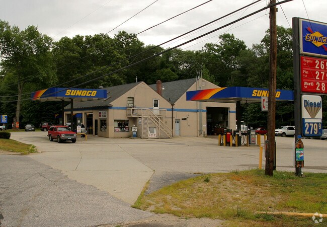
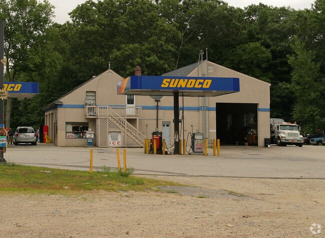
Property Record
212 Route 2, Preston, CT 06365

Property Detail
212 Route 2
PRES-000023-000002-000212
NEW LONDON
Storebuilding
Connecticut
C-1
212
B and X Area of moderate flood hazard, usually the area between the limits of the 100-year and 500-year floods.
0.89 AC
2024
NE New London/Norwich
2025
Hartford
700100
Norwich-New London-Willimantic, CT
3,696 SF
NEARBY LISTINGS FOR SALE OR LEASE
-
-
View all Preston listings for sale on LoopNet.com
DEMOGRAPHICS near 212 Route 2
1 mile
3 mile
5 mile
2025 Total Population
600
9,565
46,972
2030 Population
608
9,674
47,359
Pop Growth 2025-2030
+ 1.33%
+ 1.14%
+ 0.82%
Average Age
44
42
41
2025 Total Households
245
3,913
18,835
HH Growth 2025-2030
+ 1.22%
+ 0.92%
+ 0.78%
Median Household Inc
$74,106
$100,885
$75,104
Avg Household Size
2.30
2.40
2.40
2025 Avg HH Vehicles
2.00
2.00
2.00
Median Home Value
$321,127
$305,580
$268,118
Median Year Built
1960
1964
1961
Nearby Places
Map Layers
Map Styles
 Street
 Aerial
Layers
 Traffic
 Biking
Places
Listings with unknown addresses are not visible on the map
- Restaurants
- Banks
- Shops
- Fitness
- Groceries
PUBLIC TRANSPORTATION
AIRPORT
Rhode Island Tf Green International
Drive
Walk
Distance
Rhode Island Tf Green International
64 min
47.0 mi
Freight Ports
Port of Davisville, RI
Drive
Walk
Distance
Port of Davisville, RI
66 min
47.2 mi
Nearby Properties
Address
Land Use
TOTAL SIZE
Lot Size
Zoning
Address
Land Use
TOTAL SIZE
Lot Size
Zoning
4.59 AC
TRDD
Address
Land Use
TOTAL SIZE
Lot Size
Zoning
16,551 SF
18.11 AC
MF
Address
Land Use
TOTAL SIZE
Lot Size
Zoning
59.03 AC
RSRVT
Address
Land Use
TOTAL SIZE
Lot Size
Zoning
105,680 SF
8.50 AC
RC
Address
Land Use
TOTAL SIZE
Lot Size
Zoning
6.39 AC
MF
Address
Land Use
TOTAL SIZE
Lot Size
Zoning
15,208 SF
205.14 AC
TRDD
Address
Land Use
TOTAL SIZE
Lot Size
Zoning
78,364 SF
4.88 AC
GC
Address
Land Use
TOTAL SIZE
Lot Size
Zoning
18.90 AC
RSRVT
Address
Land Use
TOTAL SIZE
Lot Size
Zoning
3,980 SF
28.50 AC
MF
Address
Land Use
TOTAL SIZE
Lot Size
Zoning
55,321 SF
WD
Address
Land Use
TOTAL SIZE
Lot Size
Zoning
38,127 SF
0.93 AC
MF
Address
Land Use
TOTAL SIZE
Lot Size
Zoning
Address
Land Use
TOTAL SIZE
Lot Size
Zoning
43,142 SF
7.33 AC
MF
Address
Land Use
TOTAL SIZE
Lot Size
Zoning
37,286 SF
12.26 AC
R20
Address
Land Use
TOTAL SIZE
Lot Size
Zoning
41,244 SF
MF
Address
Land Use
TOTAL SIZE
Lot Size
Zoning
39,350 SF
10 AC
RC
Address
Land Use
TOTAL SIZE
Lot Size
Zoning
10.46 AC
RSRVT
Address
Land Use
TOTAL SIZE
Lot Size
Zoning
74.09 AC
TRDD
Address
Land Use
TOTAL SIZE
Lot Size
Zoning
1,449 SF
3.13 AC
MF
Address
Land Use
TOTAL SIZE
Lot Size
Zoning
31,306 SF
MF
Address
Land Use
TOTAL SIZE
Lot Size
Zoning
12.49 AC
RCCD
Address
Land Use
TOTAL SIZE
Lot Size
Zoning
3.06 AC
R20
Address
Land Use
TOTAL SIZE
Lot Size
Zoning
34,347 SF
29.70 AC
TRDD
Address
Land Use
TOTAL SIZE
Lot Size
Zoning
7.68 AC
RCCD
Address
Land Use
TOTAL SIZE
Lot Size
Zoning
15.38 AC
R40
Address
Land Use
TOTAL SIZE
Lot Size
Zoning
5.76 AC
Address
Land Use
TOTAL SIZE
Lot Size
Zoning
1,023 SF
17.10 AC
R-60
Address
Land Use
TOTAL SIZE
Lot Size
Zoning
14.30 AC
PDD
Address
Land Use
TOTAL SIZE
Lot Size
Zoning
5.16 AC
R40
Address
Land Use
TOTAL SIZE
Lot Size
Zoning
47.92 AC
TRDD
The World's #1 Commercial Real Estate Marketplace
Connect with us
© 2026 CoStar Group
The information above has been obtained from sources believed reliable. While we do not doubt its accuracy we have not verified it and make no guarantee, warranty or representation about it. It is your responsibility to independently confirm its accuracy and completeness. Any projections, opinions, assumptions, or estimates used are for example only and do not represent the current or future performance of the property. The value of this transaction to you depends on tax and other factors which should be evaluated by your tax, financial, and legal advisors. You and your advisors should conduct a careful, independent investigation of the property to determine to your satisfaction the suitability of the property for your needs.