Property Record
2120 Apple Loop, Lyons, OR 97358
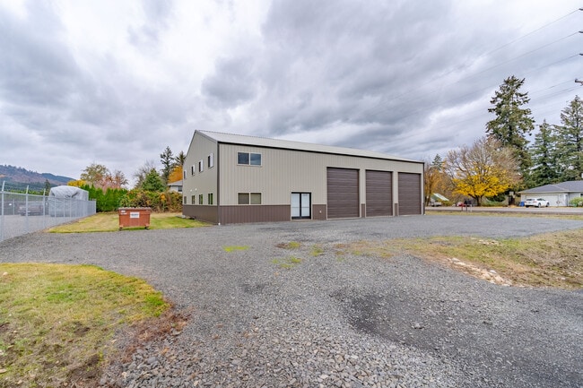


This Property Is For Sale
Property Detail
2120 Apple Loop
0867318
09S02E20C0
Commercialnec
LINN
LI
Oregon
B and X Area of moderate flood hazard, usually the area between the limits of the 100-year and 500-year floods.
0.50 AC
2025
Linn County
2025
Portland
030202
Albany, OR
NEARBY LISTINGS FOR SALE OR LEASE
DEMOGRAPHICS near 2120 Apple Loop
1 mile
3 mile
5 mile
2025 Total Population
757
2,979
3,610
2030 Population
778
3,045
3,680
Pop Growth 2025-2030
+ 2.77%
+ 2.22%
+ 1.94%
Average Age
45
45
45
2025 Total Households
290
1,147
1,377
HH Growth 2025-2030
+ 2.76%
+ 2.35%
+ 2.03%
Median Household Inc
$104,753
$101,263
$103,857
Avg Household Size
2.60
2.60
2.60
2025 Avg HH Vehicles
3.00
2.00
3.00
Median Home Value
$582,746
$567,673
$596,416
Median Year Built
1989
1980
1978
Nearby Places
Map Layers
Map Styles
 Street
 Aerial
Transit
 Traffic
 Biking
Places
Listings with unknown addresses are not visible on the map
- Restaurants
- Banks
- Shops
- Fitness
- Groceries
Nearby Properties
Address
Land Use
TOTAL SIZE
Lot Size
Zoning
Address
Land Use
TOTAL SIZE
Lot Size
Zoning
58.27 AC
HI
Address
Land Use
TOTAL SIZE
Lot Size
Zoning
109.42 AC
UGA-HI
Address
Land Use
TOTAL SIZE
Lot Size
Zoning
2.20 AC
OL/PUB
Address
Land Use
TOTAL SIZE
Lot Size
Zoning
0.23 AC
OL/PUB
Address
Land Use
TOTAL SIZE
Lot Size
Zoning
36,400 SF
2.21 AC
LI
Address
Land Use
TOTAL SIZE
Lot Size
Zoning
1.24 AC
OL/PUB
Address
Land Use
TOTAL SIZE
Lot Size
Zoning
9,957 SF
1.15 AC
C
Address
Land Use
TOTAL SIZE
Lot Size
Zoning
11.90 AC
IG
Address
Land Use
TOTAL SIZE
Lot Size
Zoning
4,985 SF
1.52 AC
R-1
Address
Land Use
TOTAL SIZE
Lot Size
Zoning
9.64 AC
LI
Address
Land Use
TOTAL SIZE
Lot Size
Zoning
560 SF
0.92 AC
C
Address
Land Use
TOTAL SIZE
Lot Size
Zoning
5,611 SF
1.26 AC
CR
Address
Land Use
TOTAL SIZE
Lot Size
Zoning
1.66 AC
IG
Address
Land Use
TOTAL SIZE
Lot Size
Zoning
6,000 SF
0.38 AC
CC
Address
Land Use
TOTAL SIZE
Lot Size
Zoning
1,743 SF
30.03 AC
UGA-HI
Address
Land Use
TOTAL SIZE
Lot Size
Zoning
21,230 SF
19.89 AC
IUC; EFU
Address
Land Use
TOTAL SIZE
Lot Size
Zoning
1.39 AC
LI
Address
Land Use
TOTAL SIZE
Lot Size
Zoning
4,800 SF
1.25 AC
CC
Address
Land Use
TOTAL SIZE
Lot Size
Zoning
16.23 AC
UGA-HI
Address
Land Use
TOTAL SIZE
Lot Size
Zoning
1.43 AC
LI
Address
Land Use
TOTAL SIZE
Lot Size
Zoning
2,304 SF
2.74 AC
LI
Address
Land Use
TOTAL SIZE
Lot Size
Zoning
18,750 SF
9.43 AC
IUC
Address
Land Use
TOTAL SIZE
Lot Size
Zoning
0.22 AC
C
Address
Land Use
TOTAL SIZE
Lot Size
Zoning
2.69 AC
OL/PUB
Address
Land Use
TOTAL SIZE
Lot Size
Zoning
2,322 SF
0.50 AC
R-1
Address
Land Use
TOTAL SIZE
Lot Size
Zoning
288 SF
17.50 AC
SA
Address
Land Use
TOTAL SIZE
Lot Size
Zoning
3,900 SF
20.71 AC
AR; EFU
Address
Land Use
TOTAL SIZE
Lot Size
Zoning
0.30 AC
C
Address
Land Use
TOTAL SIZE
Lot Size
Zoning
1.75 AC
UGA-LI
Address
Land Use
TOTAL SIZE
Lot Size
Zoning
0.26 AC
OL/PUB
The World's #1 Commercial Real Estate Marketplace
Connect with us
© 2026 CoStar Group
The information above has been obtained from sources believed reliable. While we do not doubt its accuracy we have not verified it and make no guarantee, warranty or representation about it. It is your responsibility to independently confirm its accuracy and completeness. Any projections, opinions, assumptions, or estimates used are for example only and do not represent the current or future performance of the property. The value of this transaction to you depends on tax and other factors which should be evaluated by your tax, financial, and legal advisors. You and your advisors should conduct a careful, independent investigation of the property to determine to your satisfaction the suitability of the property for your needs.