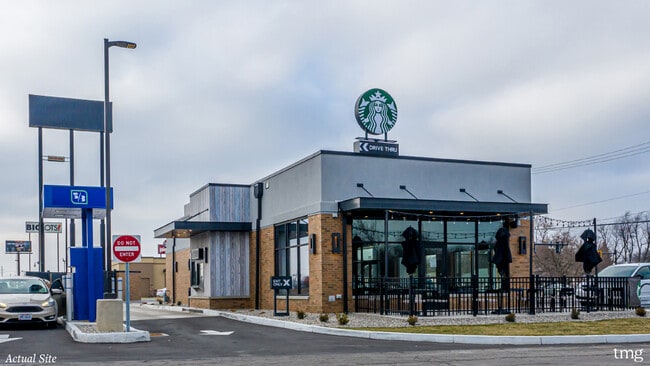
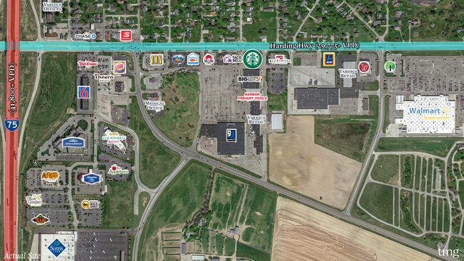
Property Record
2120 Harding Hwy, Lima, OH 45804
NEARBY LISTINGS FOR SALE OR LEASE
Property Detail
2120 Harding Hwy
47-04-00-02-001.000
PT NW1/4 RTS 07-04-04
Restaurantbuilding
Allen
X
Ohio
39003C0330E
0.45 AC
2024
Lima/Findlay
2024
Other Market Areas
011600
Lima, OH
2,267 SF
DEMOGRAPHICS near 2120 Harding Hwy
1 Mile
3 Mile
5 Mile
2024 Total Population
2,817
26,671
57,999
2029 Population
2,787
26,907
57,891
Pop Growth 2024-2029
(1.06%)
+ 0.88%
(0.19%)
Average Age
43
39
39
2024 Total Households
1,256
11,015
23,691
HH Growth 2024-2029
(1.27%)
+ 0.72%
(0.29%)
Median Household Inc
$46,311
$36,067
$42,970
Avg Household Size
2.20
2.30
2.30
2024 Avg HH Vehicles
2.00
2.00
2.00
Median Home Value
$102,967
$82,370
$103,407
Median Year Built
1973
1954
1961
Nearby Places
Map Layers
Map Styles
 Street
 Aerial
- Restaurants
- Banks
- Shops
- Fitness
- Groceries
SALE & LEASE HISTORY
LISTING DATE
SALE/LEASE

Jan 18, 2021
For Sale
Nearby Properties
Address
Land Use
TOTAL SIZE
Lot Size
Zoning
Address
Land Use
TOTAL SIZE
Lot Size
Zoning
628,932 SF
9.08 AC
Address
Land Use
TOTAL SIZE
Lot Size
Zoning
359,238 SF
9.72 AC
Address
Land Use
TOTAL SIZE
Lot Size
Zoning
242,023 SF
3.81 AC
Address
Land Use
TOTAL SIZE
Lot Size
Zoning
398,426 SF
563.43 AC
Address
Land Use
TOTAL SIZE
Lot Size
Zoning
387.31 AC
Address
Land Use
TOTAL SIZE
Lot Size
Zoning
285,016 SF
31.90 AC
Address
Land Use
TOTAL SIZE
Lot Size
Zoning
5,520 SF
12.99 AC
Address
Land Use
TOTAL SIZE
Lot Size
Zoning
681,400 SF
14.86 AC
Address
Land Use
TOTAL SIZE
Lot Size
Zoning
131,584 SF
32.09 AC
Address
Land Use
TOTAL SIZE
Lot Size
Zoning
104,798 SF
0.94 AC
Address
Land Use
TOTAL SIZE
Lot Size
Zoning
325,000 SF
15.93 AC
Address
Land Use
TOTAL SIZE
Lot Size
Zoning
120,810 SF
35.76 AC
Address
Land Use
TOTAL SIZE
Lot Size
Zoning
116,005 SF
8.17 AC
Address
Land Use
TOTAL SIZE
Lot Size
Zoning
43.28 AC
Address
Land Use
TOTAL SIZE
Lot Size
Zoning
321,048 SF
27.37 AC
Address
Land Use
TOTAL SIZE
Lot Size
Zoning
62,626 SF
5.16 AC
Address
Land Use
TOTAL SIZE
Lot Size
Zoning
585,479 SF
28.85 AC
Address
Land Use
TOTAL SIZE
Lot Size
Zoning
101,362 SF
2.78 AC
Address
Land Use
TOTAL SIZE
Lot Size
Zoning
80,130 SF
6.69 AC
Address
Land Use
TOTAL SIZE
Lot Size
Zoning
54,478 SF
10.35 AC
Address
Land Use
TOTAL SIZE
Lot Size
Zoning
58,280 SF
2.60 AC
Address
Land Use
TOTAL SIZE
Lot Size
Zoning
62,566 SF
13 AC
Address
Land Use
TOTAL SIZE
Lot Size
Zoning
177,577 SF
15.99 AC
Address
Land Use
TOTAL SIZE
Lot Size
Zoning
65,986 SF
6.50 AC
Address
Land Use
TOTAL SIZE
Lot Size
Zoning
87,128 SF
1.89 AC
Address
Land Use
TOTAL SIZE
Lot Size
Zoning
100,154 SF
2.39 AC
Address
Land Use
TOTAL SIZE
Lot Size
Zoning
356,950 SF
12.41 AC
Address
Land Use
TOTAL SIZE
Lot Size
Zoning
73,879 SF
3.01 AC
Address
Land Use
TOTAL SIZE
Lot Size
Zoning
58,959 SF
3.83 AC
Address
Land Use
TOTAL SIZE
Lot Size
Zoning
118,746 SF
60.15 AC
The World's #1 Commercial Real Estate Marketplace
Connect with us
© 2025 CoStar Group
The information above has been obtained from sources believed reliable. While we do not doubt its accuracy we have not verified it and make no guarantee, warranty or representation about it. It is your responsibility to independently confirm its accuracy and completeness. Any projections, opinions, assumptions, or estimates used are for example only and do not represent the current or future performance of the property. The value of this transaction to you depends on tax and other factors which should be evaluated by your tax, financial, and legal advisors. You and your advisors should conduct a careful, independent investigation of the property to determine to your satisfaction the suitability of the property for your needs.