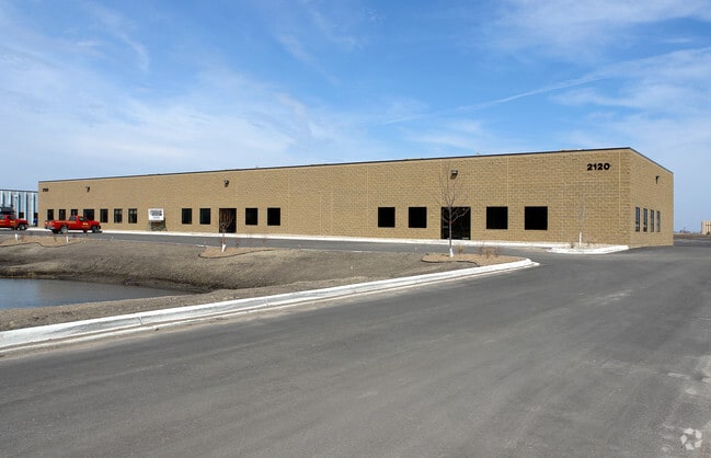
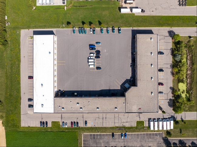
Property Record
2120 Howard Dr W, North Mankato, MN 56003

Current Lease Availabilities
Property Detail
2120 Howard Dr W
Mankato, MN
BLOCK 1 LOT 2 SUBDIVISIONCD 18174 SUBDIVISIONNAME NORTHPORT 11
R-18.174.0020
NICOLLET
Commercialnec
Minnesota
B and X Area of moderate flood hazard, usually the area between the limits of the 100-year and 500-year floods.
2
2025
4.86 AC
2025
North Mankato
480502
Other Market Areas
43,959 SF
NEARBY LISTINGS FOR SALE OR LEASE
DEMOGRAPHICS near 2120 Howard Dr W
1 mile
3 mile
5 mile
2025 Total Population
3,681
21,094
56,172
2030 Population
3,677
20,990
56,511
Pop Growth 2025-2030
(0.11%)
(0.49%)
+ 0.60%
Average Age
39
39
36
2025 Total Households
1,525
8,664
22,194
HH Growth 2025-2030
+ 0.13%
(0.38%)
+ 0.61%
Median Household Inc
$79,951
$71,966
$66,253
Avg Household Size
2.40
2.40
2.30
2025 Avg HH Vehicles
2.00
2.00
2.00
Median Home Value
$287,860
$270,207
$268,400
Median Year Built
1997
1973
1977
Nearby Places
Map Layers
Map Styles
 Street
 Aerial
Transit
 Traffic
 Biking
Places
Listings with unknown addresses are not visible on the map
- Restaurants
- Banks
- Shops
- Fitness
- Groceries
Nearby Properties
Address
Land Use
TOTAL SIZE
Lot Size
Zoning
Address
Land Use
TOTAL SIZE
Lot Size
Zoning
616,099 SF
4.06 AC
Address
Land Use
TOTAL SIZE
Lot Size
Zoning
269,842 SF
48.03 AC
Address
Land Use
TOTAL SIZE
Lot Size
Zoning
130,218 SF
39.09 AC
Address
Land Use
TOTAL SIZE
Lot Size
Zoning
219,165 SF
24.49 AC
Address
Land Use
TOTAL SIZE
Lot Size
Zoning
12,400 SF
60.45 AC
Address
Land Use
TOTAL SIZE
Lot Size
Zoning
26,500 SF
3.31 AC
Address
Land Use
TOTAL SIZE
Lot Size
Zoning
58,604 SF
1.19 AC
Address
Land Use
TOTAL SIZE
Lot Size
Zoning
16.15 AC
Address
Land Use
TOTAL SIZE
Lot Size
Zoning
67,200 SF
13.04 AC
Address
Land Use
TOTAL SIZE
Lot Size
Zoning
24,568 SF
3.48 AC
Address
Land Use
TOTAL SIZE
Lot Size
Zoning
4.28 AC
Address
Land Use
TOTAL SIZE
Lot Size
Zoning
13,886 SF
19.50 AC
Address
Land Use
TOTAL SIZE
Lot Size
Zoning
10.72 AC
Address
Land Use
TOTAL SIZE
Lot Size
Zoning
60,000 SF
9.11 AC
Address
Land Use
TOTAL SIZE
Lot Size
Zoning
43,476 SF
6.37 AC
Address
Land Use
TOTAL SIZE
Lot Size
Zoning
272,428 SF
22.09 AC
Address
Land Use
TOTAL SIZE
Lot Size
Zoning
185,200 SF
12.87 AC
Address
Land Use
TOTAL SIZE
Lot Size
Zoning
73,151 SF
0.27 AC
Address
Land Use
TOTAL SIZE
Lot Size
Zoning
213,294 SF
12.56 AC
Address
Land Use
TOTAL SIZE
Lot Size
Zoning
73,749 SF
64.75 AC
Address
Land Use
TOTAL SIZE
Lot Size
Zoning
81,111 SF
4.48 AC
Address
Land Use
TOTAL SIZE
Lot Size
Zoning
1.96 AC
Address
Land Use
TOTAL SIZE
Lot Size
Zoning
64,757 SF
2.46 AC
Address
Land Use
TOTAL SIZE
Lot Size
Zoning
57,710 SF
14.10 AC
Address
Land Use
TOTAL SIZE
Lot Size
Zoning
70,656 SF
2.85 AC
Address
Land Use
TOTAL SIZE
Lot Size
Zoning
12,800 SF
8.75 AC
Address
Land Use
TOTAL SIZE
Lot Size
Zoning
204,800 SF
9.13 AC
Address
Land Use
TOTAL SIZE
Lot Size
Zoning
10,752 SF
6.38 AC
Address
Land Use
TOTAL SIZE
Lot Size
Zoning
72,992 SF
1.41 AC
Address
Land Use
TOTAL SIZE
Lot Size
Zoning
34,200 SF
19.47 AC
The World's #1 Commercial Real Estate Marketplace
Connect with us
© 2026 CoStar Group
The information above has been obtained from sources believed reliable. While we do not doubt its accuracy we have not verified it and make no guarantee, warranty or representation about it. It is your responsibility to independently confirm its accuracy and completeness. Any projections, opinions, assumptions, or estimates used are for example only and do not represent the current or future performance of the property. The value of this transaction to you depends on tax and other factors which should be evaluated by your tax, financial, and legal advisors. You and your advisors should conduct a careful, independent investigation of the property to determine to your satisfaction the suitability of the property for your needs.