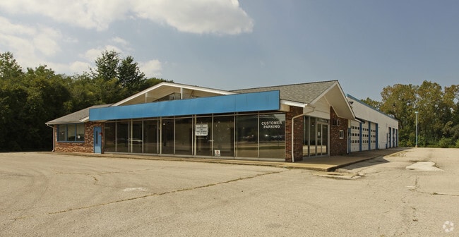
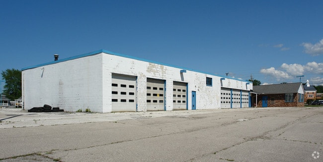
Property Record
2120 Mentor Ave, Painesville, OH 44077

NEARBY LISTINGS FOR SALE OR LEASE
Property Detail
2120 Mentor Ave
Cleveland-Elyria, OH
Mentor Ave
11-A-014-D-00-014
LOT 37 TRACT 4
Vehiclerentalsvehiclesales
Lake
X
Ohio
39085C0108F
37
0
6.30 AC
2024
Northeast
204700
Cleveland
8,579 SF
DEMOGRAPHICS near 2120 Mentor Ave
1 Mile
3 Mile
5 Mile
2024 Total Population
7,424
46,440
102,532
2029 Population
7,351
46,269
102,160
Pop Growth 2024-2029
(0.98%)
(0.37%)
(0.36%)
Average Age
47
44
43
2024 Total Households
3,309
19,044
42,678
HH Growth 2024-2029
(1.12%)
(0.44%)
(0.40%)
Median Household Inc
$87,068
$89,932
$80,711
Avg Household Size
2.20
2.40
2.30
2024 Avg HH Vehicles
2.00
2.00
2.00
Median Home Value
$205,408
$220,723
$201,622
Median Year Built
1978
1977
1975
Nearby Places
Map Layers
Map Styles
 Street
 Aerial
- Restaurants
- Banks
- Shops
- Fitness
- Groceries
PUBLIC TRANSPORTATION
AIRPORT
Cleveland-Hopkins International
DRIVE
WALK
Distance
Cleveland-Hopkins International
60 min
40.7 mi
SALE & LEASE HISTORY
LISTING DATE
SALE/LEASE

May 18, 2017
For Lease
Nearby Properties
Address
Land Use
TOTAL SIZE
Lot Size
Zoning
Address
Land Use
TOTAL SIZE
Lot Size
Zoning
441,820 SF
45.04 AC
Address
Land Use
TOTAL SIZE
Lot Size
Zoning
15.89 AC
Address
Land Use
TOTAL SIZE
Lot Size
Zoning
363,629 SF
41.78 AC
R-4
Address
Land Use
TOTAL SIZE
Lot Size
Zoning
241,548 SF
22.28 AC
Address
Land Use
TOTAL SIZE
Lot Size
Zoning
89,317 SF
7.64 AC
Address
Land Use
TOTAL SIZE
Lot Size
Zoning
212,618 SF
10.04 AC
C1
Address
Land Use
TOTAL SIZE
Lot Size
Zoning
57,904 SF
3.61 AC
Address
Land Use
TOTAL SIZE
Lot Size
Zoning
580,720 SF
22.25 AC
R-4
Address
Land Use
TOTAL SIZE
Lot Size
Zoning
16,955 SF
69.10 AC
B3
Address
Land Use
TOTAL SIZE
Lot Size
Zoning
197,433 SF
26.82 AC
R-1
Address
Land Use
TOTAL SIZE
Lot Size
Zoning
335,285 SF
25.43 AC
M-2
Address
Land Use
TOTAL SIZE
Lot Size
Zoning
13.60 AC
Address
Land Use
TOTAL SIZE
Lot Size
Zoning
158,554 SF
23.10 AC
B-2
Address
Land Use
TOTAL SIZE
Lot Size
Zoning
111,506 SF
9.84 AC
Address
Land Use
TOTAL SIZE
Lot Size
Zoning
137,183 SF
12.35 AC
Address
Land Use
TOTAL SIZE
Lot Size
Zoning
198,502 SF
39.56 AC
Address
Land Use
TOTAL SIZE
Lot Size
Zoning
Address
Land Use
TOTAL SIZE
Lot Size
Zoning
57,744 SF
3.29 AC
Address
Land Use
TOTAL SIZE
Lot Size
Zoning
55,441 SF
8.82 AC
R-4
Address
Land Use
TOTAL SIZE
Lot Size
Zoning
101,472 SF
9.07 AC
B-2
Address
Land Use
TOTAL SIZE
Lot Size
Zoning
211,307 SF
11.29 AC
M-1
Address
Land Use
TOTAL SIZE
Lot Size
Zoning
59,448 SF
Address
Land Use
TOTAL SIZE
Lot Size
Zoning
188,875 SF
25.67 AC
M-2
Address
Land Use
TOTAL SIZE
Lot Size
Zoning
138,290 SF
1.73 AC
M-1
Address
Land Use
TOTAL SIZE
Lot Size
Zoning
61,567 SF
25.17 AC
Address
Land Use
TOTAL SIZE
Lot Size
Zoning
187,661 SF
22.19 AC
R-4
Address
Land Use
TOTAL SIZE
Lot Size
Zoning
Address
Land Use
TOTAL SIZE
Lot Size
Zoning
122,256 SF
11.73 AC
B-2
Address
Land Use
TOTAL SIZE
Lot Size
Zoning
196,026 SF
23 AC
B-2
Address
Land Use
TOTAL SIZE
Lot Size
Zoning
12.50 AC
The World's #1 Commercial Real Estate Marketplace
Connect with us
© 2025 CoStar Group
The information above has been obtained from sources believed reliable. While we do not doubt its accuracy we have not verified it and make no guarantee, warranty or representation about it. It is your responsibility to independently confirm its accuracy and completeness. Any projections, opinions, assumptions, or estimates used are for example only and do not represent the current or future performance of the property. The value of this transaction to you depends on tax and other factors which should be evaluated by your tax, financial, and legal advisors. You and your advisors should conduct a careful, independent investigation of the property to determine to your satisfaction the suitability of the property for your needs.