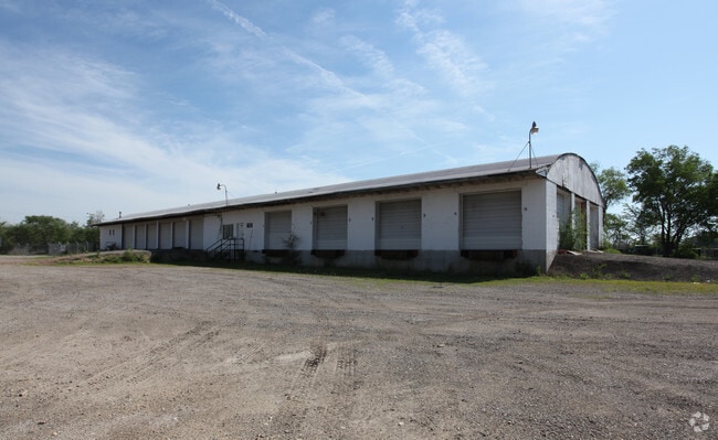
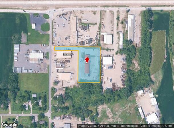
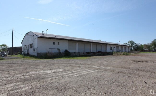
Property Record
2120 Ne Meriden Rd, Topeka, KS 66608
NEARBY LISTINGS FOR SALE OR LEASE
Property Detail
2120 Ne Meriden Rd
Topeka, KS
Ivan Thompson Sub No 3
105-16-0-30-06-013-000
IVAN THOMPSON SUB NO 3, S16, T11, R16, BLOCK A, LOT 2, ACRES 2.27, BLK A LOT 2 IVAN THOMPSON SUB NO 3
Commercialnec
Shawnee
X
Kansas
20177C0209E
2
2024
2.27 AC
2025
Topeka
000800
Kansas City
8,695 SF
DEMOGRAPHICS near 2120 Ne Meriden Rd
1 Mile
3 Mile
5 Mile
2024 Total Population
2,020
22,179
71,104
2029 Population
2,012
22,143
70,950
Pop Growth 2024-2029
(0.40%)
(0.16%)
(0.22%)
Average Age
41
40
39
2024 Total Households
861
9,053
28,697
HH Growth 2024-2029
(0.46%)
(0.19%)
(0.18%)
Median Household Inc
$51,200
$45,848
$47,391
Avg Household Size
2.30
2.30
2.30
2024 Avg HH Vehicles
2.00
2.00
2.00
Median Home Value
$132,158
$92,076
$100,849
Median Year Built
1975
1953
1957
Nearby Places
Map Layers
Map Styles
 Street
 Aerial
- Restaurants
- Banks
- Shops
- Fitness
- Groceries
PUBLIC TRANSPORTATION
COMMUTER RAIL
Topeka Amtrak Station (Southwest Chief - Amtrak)
DRIVE
WALK
Distance
Topeka Amtrak Station (Southwest Chief - Amtrak)
9 min
4.0 mi
Freight Ports
Tulsa Port Of Catoosa
DRIVE
WALK
Distance
Tulsa Port Of Catoosa
282 min
238.4 mi
Nearby Properties
Address
Land Use
TOTAL SIZE
Lot Size
Zoning
Address
Land Use
TOTAL SIZE
Lot Size
Zoning
181,781 SF
569.17 AC
R1
Address
Land Use
TOTAL SIZE
Lot Size
Zoning
127,947 SF
7.12 AC
C5
Address
Land Use
TOTAL SIZE
Lot Size
Zoning
129,425 SF
96.26 AC
R1
Address
Land Use
TOTAL SIZE
Lot Size
Zoning
101,766 SF
2.39 AC
C5,I1
Address
Land Use
TOTAL SIZE
Lot Size
Zoning
92,118 SF
10.87 AC
R2
Address
Land Use
TOTAL SIZE
Lot Size
Zoning
61,680 SF
2.20 AC
C5
Address
Land Use
TOTAL SIZE
Lot Size
Zoning
70,058 SF
1.03 AC
C5
Address
Land Use
TOTAL SIZE
Lot Size
Zoning
238,319 SF
170.40 AC
PUD,RR1,OI
Address
Land Use
TOTAL SIZE
Lot Size
Zoning
26,269 SF
8.18 AC
RR1
Address
Land Use
TOTAL SIZE
Lot Size
Zoning
88,401 SF
1.51 AC
C5
Address
Land Use
TOTAL SIZE
Lot Size
Zoning
18,984 SF
0.35 AC
HL,X3
Address
Land Use
TOTAL SIZE
Lot Size
Zoning
47,037 SF
8 AC
R2
Address
Land Use
TOTAL SIZE
Lot Size
Zoning
27,718 SF
24.23 AC
RR1
Address
Land Use
TOTAL SIZE
Lot Size
Zoning
60,498 SF
1.02 AC
C5
Address
Land Use
TOTAL SIZE
Lot Size
Zoning
63,903 SF
5.05 AC
R2
Address
Land Use
TOTAL SIZE
Lot Size
Zoning
35,055 SF
109.89 AC
RR1
Address
Land Use
TOTAL SIZE
Lot Size
Zoning
96,600 SF
23.56 AC
R1
Address
Land Use
TOTAL SIZE
Lot Size
Zoning
38,125 SF
2.55 AC
C5
Address
Land Use
TOTAL SIZE
Lot Size
Zoning
28,978 SF
2.90 AC
PUD,M3
Address
Land Use
TOTAL SIZE
Lot Size
Zoning
72,295 SF
13.39 AC
R1
Address
Land Use
TOTAL SIZE
Lot Size
Zoning
2,595,744 SF
197.79 AC
I2
Address
Land Use
TOTAL SIZE
Lot Size
Zoning
24,462 SF
40.76 AC
OS1
Address
Land Use
TOTAL SIZE
Lot Size
Zoning
12,464 SF
0.35 AC
I2
Address
Land Use
TOTAL SIZE
Lot Size
Zoning
35,320 SF
2.90 AC
R2
Address
Land Use
TOTAL SIZE
Lot Size
Zoning
35,335 SF
3.08 AC
PUD,C2
Address
Land Use
TOTAL SIZE
Lot Size
Zoning
88,238 SF
32.42 AC
R1,R2
Address
Land Use
TOTAL SIZE
Lot Size
Zoning
18,768 SF
14.94 AC
PUD,M2
Address
Land Use
TOTAL SIZE
Lot Size
Zoning
194,614 SF
23.42 AC
PUD,C4,R1
Address
Land Use
TOTAL SIZE
Lot Size
Zoning
49,341 SF
4.86 AC
D3
Address
Land Use
TOTAL SIZE
Lot Size
Zoning
43,519 SF
1.39 AC
I1
The World's #1 Commercial Real Estate Marketplace
Connect with us
© 2026 CoStar Group
The information above has been obtained from sources believed reliable. While we do not doubt its accuracy we have not verified it and make no guarantee, warranty or representation about it. It is your responsibility to independently confirm its accuracy and completeness. Any projections, opinions, assumptions, or estimates used are for example only and do not represent the current or future performance of the property. The value of this transaction to you depends on tax and other factors which should be evaluated by your tax, financial, and legal advisors. You and your advisors should conduct a careful, independent investigation of the property to determine to your satisfaction the suitability of the property for your needs.