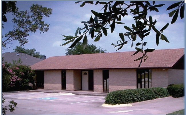
Property Record
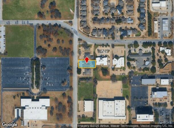
2120 Parkwood Dr, Bedford, TX 76021

NEARBY LISTINGS FOR SALE OR LEASE
Property Detail
2120 Parkwood Dr
04284046
Williams, T W Survey
Commercialnec
WILLIAMS, T W SURVEY ABSTRACT 1735 TRACT 2G02 ABST 1735 TRS 2G2 & 2G2A
X
Tarrant
48439C0210K
Texas
2023
0.41 AC
2025
HEB/Mid-Cities
113629
Dallas/Ft Worth
3,095 SF
Dallas-Fort Worth-Arlington, TX
DEMOGRAPHICS near 2120 Parkwood Dr
1 Mile
3 Mile
5 Mile
2024 Total Population
17,796
110,225
264,705
2029 Population
18,691
116,052
278,921
Pop Growth 2024-2029
+ 5.03%
+ 5.29%
+ 5.37%
Average Age
39
40
39
2024 Total Households
8,529
43,838
106,161
HH Growth 2024-2029
+ 5.08%
+ 5.30%
+ 5.37%
Median Household Inc
$56,975
$74,747
$78,964
Avg Household Size
2.00
2.50
2.40
2024 Avg HH Vehicles
1.00
2.00
2.00
Median Home Value
$272,667
$285,927
$322,678
Median Year Built
1984
1980
1985
Nearby Places
Map Layers
Map Styles
 Street
 Aerial
- Restaurants
- Banks
- Shops
- Fitness
- Groceries
PUBLIC TRANSPORTATION
COMMUTER RAIL
Hurst/Bell (Trinity Railway Express - Dallas Area Rapid Transit (DART))
DRIVE
WALK
Distance
Hurst/Bell (Trinity Railway Express - Dallas Area Rapid Transit (DART))
8 min
3.7 mi
Centre Port/DFW (Trinity Railway Express - Dallas Area Rapid Transit (DART))
DRIVE
WALK
Distance
Centre Port/DFW (Trinity Railway Express - Dallas Area Rapid Transit (DART))
12 min
6.7 mi
AIRPORT
Dallas-Fort Worth International
DRIVE
WALK
Distance
Dallas-Fort Worth International
18 min
11.1 mi
Dallas Love Field
DRIVE
WALK
Distance
Dallas Love Field
28 min
19.7 mi
Nearby Properties
Address
Land Use
TOTAL SIZE
Lot Size
Zoning
Address
Land Use
TOTAL SIZE
Lot Size
Zoning
631,558 SF
15.49 AC
Address
Land Use
TOTAL SIZE
Lot Size
Zoning
415,563 SF
25.40 AC
Address
Land Use
TOTAL SIZE
Lot Size
Zoning
363,849 SF
8.08 AC
Address
Land Use
TOTAL SIZE
Lot Size
Zoning
290,680 SF
26.31 AC
Address
Land Use
TOTAL SIZE
Lot Size
Zoning
356,000 SF
39.44 AC
Address
Land Use
TOTAL SIZE
Lot Size
Zoning
1,544,748 SF
76.25 AC
Address
Land Use
TOTAL SIZE
Lot Size
Zoning
282,665 SF
14.29 AC
Address
Land Use
TOTAL SIZE
Lot Size
Zoning
172,000 SF
6.34 AC
Address
Land Use
TOTAL SIZE
Lot Size
Zoning
223,131 SF
12.50 AC
Address
Land Use
TOTAL SIZE
Lot Size
Zoning
236,016 SF
12.81 AC
Address
Land Use
TOTAL SIZE
Lot Size
Zoning
79,244 SF
54.50 AC
Address
Land Use
TOTAL SIZE
Lot Size
Zoning
269,700 SF
48.40 AC
Address
Land Use
TOTAL SIZE
Lot Size
Zoning
236,701 SF
15.96 AC
Address
Land Use
TOTAL SIZE
Lot Size
Zoning
211,449 SF
11.30 AC
Address
Land Use
TOTAL SIZE
Lot Size
Zoning
208,238 SF
12.55 AC
Address
Land Use
TOTAL SIZE
Lot Size
Zoning
346,112 SF
15.89 AC
Address
Land Use
TOTAL SIZE
Lot Size
Zoning
186,377 SF
20.59 AC
Address
Land Use
TOTAL SIZE
Lot Size
Zoning
187,382 SF
5.96 AC
Address
Land Use
TOTAL SIZE
Lot Size
Zoning
161,332 SF
8.56 AC
Address
Land Use
TOTAL SIZE
Lot Size
Zoning
201,121 SF
8.96 AC
Address
Land Use
TOTAL SIZE
Lot Size
Zoning
210,072 SF
16.84 AC
Address
Land Use
TOTAL SIZE
Lot Size
Zoning
170,141 SF
9.18 AC
Address
Land Use
TOTAL SIZE
Lot Size
Zoning
160,608 SF
8.29 AC
Address
Land Use
TOTAL SIZE
Lot Size
Zoning
192,482 SF
9.77 AC
Address
Land Use
TOTAL SIZE
Lot Size
Zoning
165,762 SF
10.71 AC
Address
Land Use
TOTAL SIZE
Lot Size
Zoning
204,270 SF
11.15 AC
Address
Land Use
TOTAL SIZE
Lot Size
Zoning
157,564 SF
9.97 AC
Address
Land Use
TOTAL SIZE
Lot Size
Zoning
201,144 SF
9.77 AC
Address
Land Use
TOTAL SIZE
Lot Size
Zoning
158,761 SF
8.91 AC
Address
Land Use
TOTAL SIZE
Lot Size
Zoning
151,550 SF
8.73 AC
The World's #1 Commercial Real Estate Marketplace
Connect with us
© 2026 CoStar Group
The information above has been obtained from sources believed reliable. While we do not doubt its accuracy we have not verified it and make no guarantee, warranty or representation about it. It is your responsibility to independently confirm its accuracy and completeness. Any projections, opinions, assumptions, or estimates used are for example only and do not represent the current or future performance of the property. The value of this transaction to you depends on tax and other factors which should be evaluated by your tax, financial, and legal advisors. You and your advisors should conduct a careful, independent investigation of the property to determine to your satisfaction the suitability of the property for your needs.