Property Record
2120 S Milford Rd, Highland, MI 48357
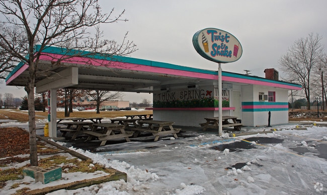
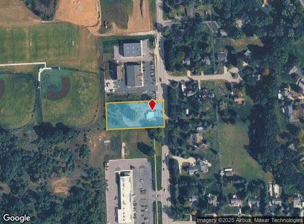
This Property Is For Sale
NEARBY LISTINGS FOR SALE OR LEASE
Property Detail
2120 S Milford Rd
11-34-101-011
T3N, R7E, SEC 34 PART OF NW 1/4 BEG AT PT DIST E 1473.60 FT & S 01-13-40 W 1173.64 FT FROM NW SEC COR, TH S 01-13-40 W 149.00 FT, TH W 335.80 FT, TH N 00-22-38 E 148.39 FT, TH E 335.56 FT TO BEG 1.15 A
Restaurantbuilding
Oakland
X
Michigan
26125C0451F
1.03 AC
2024
Central I-96 Corridor
2024
Detroit
131300
Detroit-Warren-Dearborn, MI
959 SF
DEMOGRAPHICS near 2120 S Milford Rd
1 Mile
3 Mile
5 Mile
2024 Total Population
1,282
18,702
46,530
2029 Population
1,271
18,745
46,414
Pop Growth 2024-2029
(0.86%)
+ 0.23%
(0.25%)
Average Age
44
43
43
2024 Total Households
507
7,439
17,922
HH Growth 2024-2029
(0.99%)
+ 0.08%
(0.30%)
Median Household Inc
$108,500
$99,315
$100,887
Avg Household Size
2.50
2.50
2.50
2024 Avg HH Vehicles
2.00
2.00
2.00
Median Home Value
$389,854
$352,176
$355,131
Median Year Built
1989
1988
1985
Nearby Places
Map Layers
Map Styles
 Street
 Aerial
- Restaurants
- Banks
- Shops
- Fitness
- Groceries
PUBLIC TRANSPORTATION
AIRPORT
Bishop International
DRIVE
WALK
Distance
Bishop International
51 min
34.1 mi
Freight Ports
Port of Toledo
DRIVE
WALK
Distance
Port of Toledo
105 min
83.9 mi
Nearby Properties
Address
Land Use
TOTAL SIZE
Lot Size
Zoning
Address
Land Use
TOTAL SIZE
Lot Size
Zoning
89,974 SF
Address
Land Use
TOTAL SIZE
Lot Size
Zoning
117,504 SF
12.57 AC
BI
Address
Land Use
TOTAL SIZE
Lot Size
Zoning
83,159 SF
34.44 AC
Address
Land Use
TOTAL SIZE
Lot Size
Zoning
70,308 SF
2.43 AC
Address
Land Use
TOTAL SIZE
Lot Size
Zoning
77,287 SF
1.62 AC
Address
Land Use
TOTAL SIZE
Lot Size
Zoning
70,463 SF
7.98 AC
AI
Address
Land Use
TOTAL SIZE
Lot Size
Zoning
7,616 SF
78.67 AC
MM
Address
Land Use
TOTAL SIZE
Lot Size
Zoning
72,727 SF
10.51 AC
Address
Land Use
TOTAL SIZE
Lot Size
Zoning
603.37 AC
FC
Address
Land Use
TOTAL SIZE
Lot Size
Zoning
55,844 SF
5.90 AC
AI
Address
Land Use
TOTAL SIZE
Lot Size
Zoning
34,854 SF
5.28 AC
AI
Address
Land Use
TOTAL SIZE
Lot Size
Zoning
34,075 SF
14.06 AC
BI
Address
Land Use
TOTAL SIZE
Lot Size
Zoning
51,167 SF
11.08 AC
BI
Address
Land Use
TOTAL SIZE
Lot Size
Zoning
19,596 SF
3.78 AC
Address
Land Use
TOTAL SIZE
Lot Size
Zoning
55,183 SF
Address
Land Use
TOTAL SIZE
Lot Size
Zoning
24,016 SF
7.90 AC
AV
Address
Land Use
TOTAL SIZE
Lot Size
Zoning
47,204 SF
10.77 AC
II
Address
Land Use
TOTAL SIZE
Lot Size
Zoning
24,370 SF
4.86 AC
BI
Address
Land Use
TOTAL SIZE
Lot Size
Zoning
14,689 SF
2.05 AC
BI
Address
Land Use
TOTAL SIZE
Lot Size
Zoning
27,756 SF
228.31 AC
Address
Land Use
TOTAL SIZE
Lot Size
Zoning
53,236 SF
9.68 AC
BI
Address
Land Use
TOTAL SIZE
Lot Size
Zoning
47,996 SF
8.99 AC
BI
Address
Land Use
TOTAL SIZE
Lot Size
Zoning
41,748 SF
2.20 AC
AI
Address
Land Use
TOTAL SIZE
Lot Size
Zoning
36,928 SF
5.16 AC
II
Address
Land Use
TOTAL SIZE
Lot Size
Zoning
31,676 SF
3.59 AC
BI
Address
Land Use
TOTAL SIZE
Lot Size
Zoning
58,721 SF
7.59 AC
BI
Address
Land Use
TOTAL SIZE
Lot Size
Zoning
34,464 SF
7.45 AC
AI
Address
Land Use
TOTAL SIZE
Lot Size
Zoning
68,340 SF
5.48 AC
II
Address
Land Use
TOTAL SIZE
Lot Size
Zoning
45,600 SF
3.44 AC
BI
Address
Land Use
TOTAL SIZE
Lot Size
Zoning
21,000 SF
3.12 AC
BI
The World's #1 Commercial Real Estate Marketplace
Connect with us
© 2025 CoStar Group
The information above has been obtained from sources believed reliable. While we do not doubt its accuracy we have not verified it and make no guarantee, warranty or representation about it. It is your responsibility to independently confirm its accuracy and completeness. Any projections, opinions, assumptions, or estimates used are for example only and do not represent the current or future performance of the property. The value of this transaction to you depends on tax and other factors which should be evaluated by your tax, financial, and legal advisors. You and your advisors should conduct a careful, independent investigation of the property to determine to your satisfaction the suitability of the property for your needs.