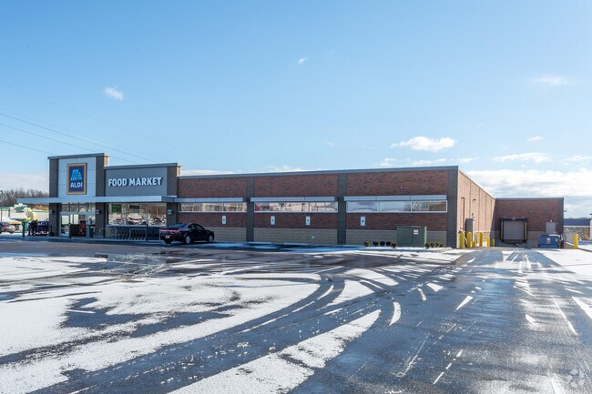
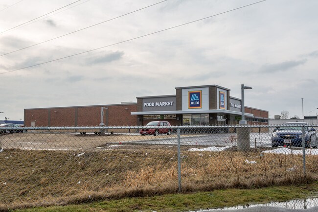
Property Record
2120 State Route 5, Cortland, OH 44410

Save to a Folder
{{folder.Name}}
{{folder.ListingIds.length}} Properties
{{folder.ListingIds.length}} Property
Create a New Folder
Property Detail
2120 State Route 5
Youngstown-Warren, OH
97 2 1.460A ELM RD
31-900880
TRUMBULL
Supermarket
Ohio
B and X Area of moderate flood hazard, usually the area between the limits of the 100-year and 500-year floods.
2
2025
1.46 AC
2025
Trumbull County
931000
Youngstown/Warren/Boardman
19,200 SF
NEARBY LISTINGS FOR SALE OR LEASE
DEMOGRAPHICS near 2120 State Route 5
1 mile
3 mile
5 mile
2025 Total Population
1,158
24,820
75,567
2030 Population
1,154
24,713
75,637
Pop Growth 2025-2030
(0.35%)
(0.43%)
+ 0.09%
Average Age
47
44
43
2025 Total Households
536
11,101
32,697
HH Growth 2025-2030
(0.37%)
(0.56%)
0.00%
Median Household Inc
$45,500
$55,222
$48,318
Avg Household Size
2.10
2.10
2.20
2025 Avg HH Vehicles
2.00
2.00
2.00
Median Home Value
$138,647
$147,189
$137,943
Median Year Built
1966
1964
1963
Nearby Places
Map Layers
Map Styles
 Street
 Aerial
Layers
 Traffic
 Biking
Places
Listings with unknown addresses are not visible on the map
- Restaurants
- Banks
- Shops
- Fitness
- Groceries
SALE & LEASE HISTORY
LISTING DATE
SALE/LEASE

Jun 05, 2018
For Sale
Nearby Properties
Address
Land Use
TOTAL SIZE
Lot Size
Zoning
Address
Land Use
TOTAL SIZE
Lot Size
Zoning
283,853 SF
17.20 AC
Address
Land Use
TOTAL SIZE
Lot Size
Zoning
44,600 SF
151.65 AC
Address
Land Use
TOTAL SIZE
Lot Size
Zoning
1,404,342 SF
72.77 AC
Address
Land Use
TOTAL SIZE
Lot Size
Zoning
26,544 SF
21.06 AC
Address
Land Use
TOTAL SIZE
Lot Size
Zoning
4,798 SF
41.21 AC
Address
Land Use
TOTAL SIZE
Lot Size
Zoning
14,710 SF
18.82 AC
Address
Land Use
TOTAL SIZE
Lot Size
Zoning
1,417 SF
51.19 AC
Address
Land Use
TOTAL SIZE
Lot Size
Zoning
175,920 SF
17.34 AC
Address
Land Use
TOTAL SIZE
Lot Size
Zoning
27,241 SF
15.10 AC
Address
Land Use
TOTAL SIZE
Lot Size
Zoning
216,467 SF
23.90 AC
Address
Land Use
TOTAL SIZE
Lot Size
Zoning
49.97 AC
Address
Land Use
TOTAL SIZE
Lot Size
Zoning
49,752 SF
11.40 AC
Address
Land Use
TOTAL SIZE
Lot Size
Zoning
142,607 SF
4.50 AC
Address
Land Use
TOTAL SIZE
Lot Size
Zoning
25,067 SF
4.74 AC
Address
Land Use
TOTAL SIZE
Lot Size
Zoning
29.72 AC
Address
Land Use
TOTAL SIZE
Lot Size
Zoning
5,358 SF
15.50 AC
Address
Land Use
TOTAL SIZE
Lot Size
Zoning
160,740 SF
4.08 AC
Address
Land Use
TOTAL SIZE
Lot Size
Zoning
5,358 SF
16.39 AC
Address
Land Use
TOTAL SIZE
Lot Size
Zoning
37,053 SF
16.46 AC
Address
Land Use
TOTAL SIZE
Lot Size
Zoning
253,756 SF
16.25 AC
Address
Land Use
TOTAL SIZE
Lot Size
Zoning
106,350 SF
17.79 AC
Address
Land Use
TOTAL SIZE
Lot Size
Zoning
44,671 SF
1.83 AC
Address
Land Use
TOTAL SIZE
Lot Size
Zoning
38,752 SF
18.49 AC
Address
Land Use
TOTAL SIZE
Lot Size
Zoning
19,011 SF
5.37 AC
Address
Land Use
TOTAL SIZE
Lot Size
Zoning
74.93 AC
Address
Land Use
TOTAL SIZE
Lot Size
Zoning
96,480 SF
11.85 AC
Address
Land Use
TOTAL SIZE
Lot Size
Zoning
4,156 SF
5.76 AC
Address
Land Use
TOTAL SIZE
Lot Size
Zoning
28,738 SF
4.54 AC
Address
Land Use
TOTAL SIZE
Lot Size
Zoning
20,720 SF
8.04 AC
Address
Land Use
TOTAL SIZE
Lot Size
Zoning
89,662 SF
12.98 AC
The World's #1 Commercial Real Estate Marketplace
Connect with us
© 2026 CoStar Group
The information above has been obtained from sources believed reliable. While we do not doubt its accuracy we have not verified it and make no guarantee, warranty or representation about it. It is your responsibility to independently confirm its accuracy and completeness. Any projections, opinions, assumptions, or estimates used are for example only and do not represent the current or future performance of the property. The value of this transaction to you depends on tax and other factors which should be evaluated by your tax, financial, and legal advisors. You and your advisors should conduct a careful, independent investigation of the property to determine to your satisfaction the suitability of the property for your needs.