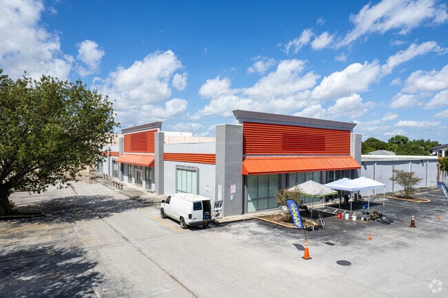
Property Record
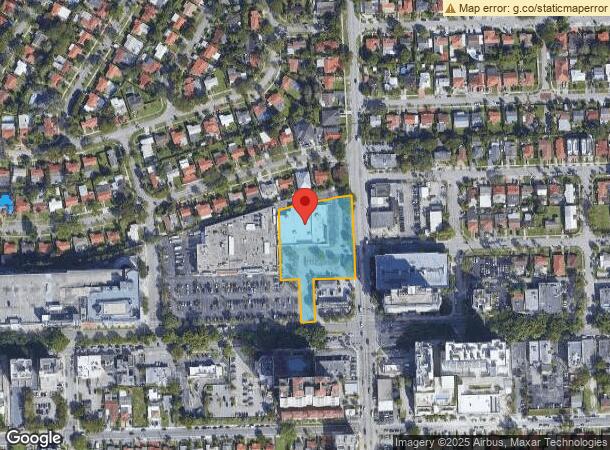
2120 Sw 32Nd Ave, Miami, FL 33145
This Property Is For Sale
NEARBY LISTINGS FOR SALE OR LEASE
Property Detail
2120 Sw 32Nd Ave
01-4109-012-0031
M/L Coral Gate
Storemultistory
9 54 41 1.95 AC M/L CORAL GATE SEC D PB 50-34 PORT OF TRACT C DESC BEG NE COR OF TRACT C TH S305FT W150FT S151.42FT W50FT N151.42FT W64.83FT N265.80FT NE37.97FT NELY A/D 200.97FT TO POB LOT SIZE 84939 SQ FT OR 19656-4977 0501 4
X
Miami/Dade
12086C0313L
Florida
2024
1.95 AC
2025
Coral Way
006302
South Florida
24,267 SF
Miami-Miami Beach-Kendall, FL
DEMOGRAPHICS near 2120 Sw 32Nd Ave
1 Mile
3 Mile
5 Mile
2024 Total Population
38,318
241,249
499,581
2029 Population
37,313
235,197
491,188
Pop Growth 2024-2029
(2.62%)
(2.51%)
(1.68%)
Average Age
44
43
42
2024 Total Households
16,284
96,108
205,089
HH Growth 2024-2029
(2.78%)
(2.63%)
(1.69%)
Median Household Inc
$59,369
$54,206
$57,406
Avg Household Size
2.30
2.40
2.30
2024 Avg HH Vehicles
1.00
1.00
1.00
Median Home Value
$430,626
$487,237
$467,118
Median Year Built
1972
1967
1976
Nearby Places
Map Layers
Map Styles
 Street
 Aerial
- Restaurants
- Banks
- Shops
- Fitness
- Groceries
PUBLIC TRANSPORTATION
COMMUTER RAIL
Coconut Grove (Metrorail Green Line - Miami-Dade Transit (Metrorail/Metromover))
DRIVE
WALK
Distance
Coconut Grove (Metrorail Green Line - Miami-Dade Transit (Metrorail/Metromover))
3 min
1.4 mi
Douglas Road (Metrorail Green Line - Miami-Dade Transit (Metrorail/Metromover))
DRIVE
WALK
Distance
Douglas Road (Metrorail Green Line - Miami-Dade Transit (Metrorail/Metromover))
5 min
1.7 mi
AIRPORT
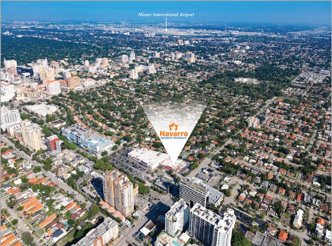
Miami International
DRIVE
WALK
Distance
Miami International
22 min
9.6 mi
Fort Lauderdale/Hollywood International
DRIVE
WALK
Distance
Fort Lauderdale/Hollywood International
40 min
27.2 mi
Nearby Properties
Address
Land Use
TOTAL SIZE
Lot Size
Zoning
Address
Land Use
TOTAL SIZE
Lot Size
Zoning
928,000 SF
14.30 AC
8000
Address
Land Use
TOTAL SIZE
Lot Size
Zoning
2,403,353 SF
7.37 AC
6100
Address
Land Use
TOTAL SIZE
Lot Size
Zoning
870,720 SF
1.90 AC
4800
Address
Land Use
TOTAL SIZE
Lot Size
Zoning
1,101,032 SF
5.18 AC
8000
Address
Land Use
TOTAL SIZE
Lot Size
Zoning
1,647,481 SF
23.04 AC
5000
Address
Land Use
TOTAL SIZE
Lot Size
Zoning
1,428,214 SF
31.07 AC
8000
Address
Land Use
TOTAL SIZE
Lot Size
Zoning
91,119 SF
50.72 AC
8000
Address
Land Use
TOTAL SIZE
Lot Size
Zoning
345,178 SF
6.73 AC
5005
Address
Land Use
TOTAL SIZE
Lot Size
Zoning
1,168,390 SF
0.04 AC
7100
Address
Land Use
TOTAL SIZE
Lot Size
Zoning
526,358 SF
3.62 AC
6100
Address
Land Use
TOTAL SIZE
Lot Size
Zoning
545,220 SF
15.32 AC
6100
Address
Land Use
TOTAL SIZE
Lot Size
Zoning
482,246 SF
0.83 AC
5005
Address
Land Use
TOTAL SIZE
Lot Size
Zoning
525,786 SF
2.64 AC
6100
Address
Land Use
TOTAL SIZE
Lot Size
Zoning
408,292 SF
0.88 AC
6110
Address
Land Use
TOTAL SIZE
Lot Size
Zoning
247,488 SF
4.25 AC
5005
Address
Land Use
TOTAL SIZE
Lot Size
Zoning
275,755 SF
6.73 AC
5005
Address
Land Use
TOTAL SIZE
Lot Size
Zoning
688,104 SF
3.16 AC
6101
Address
Land Use
TOTAL SIZE
Lot Size
Zoning
299,785 SF
0.55 AC
6110
Address
Land Use
TOTAL SIZE
Lot Size
Zoning
431,941 SF
2.06 AC
6110
Address
Land Use
TOTAL SIZE
Lot Size
Zoning
407,265 SF
1.59 AC
6100
Address
Land Use
TOTAL SIZE
Lot Size
Zoning
466,402 SF
2.22 AC
6106
Address
Land Use
TOTAL SIZE
Lot Size
Zoning
518,244 SF
1.06 AC
5005
Address
Land Use
TOTAL SIZE
Lot Size
Zoning
668,569 SF
2.33 AC
5004
Address
Land Use
TOTAL SIZE
Lot Size
Zoning
948,568 SF
6.20 AC
5005
Address
Land Use
TOTAL SIZE
Lot Size
Zoning
449,572 SF
1.74 AC
6110
Address
Land Use
TOTAL SIZE
Lot Size
Zoning
306,775 SF
29.70 AC
7000
Address
Land Use
TOTAL SIZE
Lot Size
Zoning
473,214 SF
2.51 AC
5005
Address
Land Use
TOTAL SIZE
Lot Size
Zoning
540,267 SF
1.74 AC
5005
Address
Land Use
TOTAL SIZE
Lot Size
Zoning
173,357 SF
30.51 AC
8000
Address
Land Use
TOTAL SIZE
Lot Size
Zoning
290,132 SF
1.46 AC
6110
The World's #1 Commercial Real Estate Marketplace
Connect with us
© 2026 CoStar Group
The information above has been obtained from sources believed reliable. While we do not doubt its accuracy we have not verified it and make no guarantee, warranty or representation about it. It is your responsibility to independently confirm its accuracy and completeness. Any projections, opinions, assumptions, or estimates used are for example only and do not represent the current or future performance of the property. The value of this transaction to you depends on tax and other factors which should be evaluated by your tax, financial, and legal advisors. You and your advisors should conduct a careful, independent investigation of the property to determine to your satisfaction the suitability of the property for your needs.