Property Record
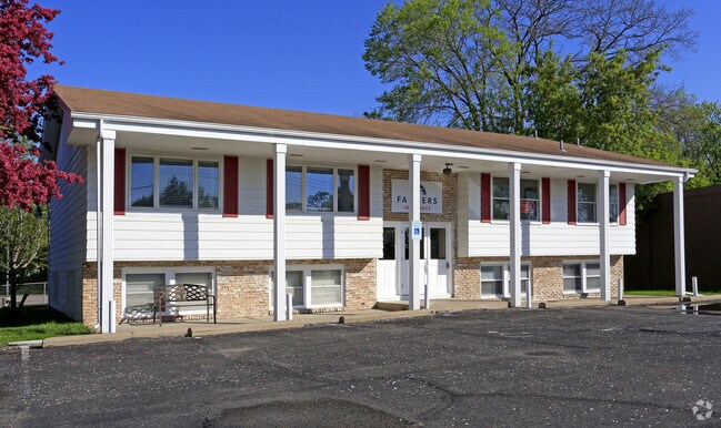
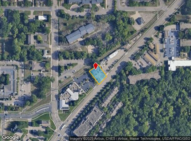
2120 W Old Shakopee Rd, Minneapolis, MN 55431

NEARBY LISTINGS FOR SALE OR LEASE
Property Detail
2120 W Old Shakopee Rd
16-027-24-33-0003
Unplatted 16 027 24
Commercialnec
UNPLATTED 16 027 24 COM AT A PT IN THE SELY LINE OF M N AND S R R R&W DIS 363 FT NELY ALONG SAID R&W LINE FROM THE W LINE OF SEC TH NELY ALONG SAID R&W T IRREGULAR
X
Hennepin
27053C0458F
Minnesota
2024
0.31 AC
2024
I-494 Corridor
025801
Minneapolis/St Paul
2,094 SF
Minneapolis-St. Paul-Bloomington, MN-WI
DEMOGRAPHICS near 2120 W Old Shakopee Rd
1 Mile
3 Mile
5 Mile
2024 Total Population
9,633
60,539
203,820
2029 Population
9,489
59,391
203,165
Pop Growth 2024-2029
(1.49%)
(1.90%)
(0.32%)
Average Age
43
43
42
2024 Total Households
4,107
25,331
86,438
HH Growth 2024-2029
(1.44%)
(2.04%)
(0.36%)
Median Household Inc
$84,183
$83,671
$81,178
Avg Household Size
2.20
2.30
2.30
2024 Avg HH Vehicles
2.00
2.00
2.00
Median Home Value
$322,692
$305,661
$308,225
Median Year Built
1967
1966
1973
Nearby Places
Map Layers
Map Styles
 Street
 Aerial
- Restaurants
- Banks
- Shops
- Fitness
- Groceries
PUBLIC TRANSPORTATION
AIRPORT
Minneapolis-St Paul International/Wold-Chamberlain
DRIVE
WALK
Distance
Minneapolis-St Paul International/Wold-Chamberlain
14 min
8.7 mi
Freight Ports
Port Milwaukee
DRIVE
WALK
Distance
Port Milwaukee
383 min
345.8 mi
SALE & LEASE HISTORY
LISTING DATE
SALE/LEASE

May 21, 2019
For Lease
Nearby Properties
Address
Land Use
TOTAL SIZE
Lot Size
Zoning
Address
Land Use
TOTAL SIZE
Lot Size
Zoning
1,341.19 AC
Address
Land Use
TOTAL SIZE
Lot Size
Zoning
435,796 SF
36.44 AC
Address
Land Use
TOTAL SIZE
Lot Size
Zoning
129,658 SF
13.52 AC
Address
Land Use
TOTAL SIZE
Lot Size
Zoning
581,195 SF
37 AC
Address
Land Use
TOTAL SIZE
Lot Size
Zoning
105,658 SF
18.80 AC
Address
Land Use
TOTAL SIZE
Lot Size
Zoning
Address
Land Use
TOTAL SIZE
Lot Size
Zoning
122,021 SF
21.74 AC
Address
Land Use
TOTAL SIZE
Lot Size
Zoning
60,320 SF
11.50 AC
Address
Land Use
TOTAL SIZE
Lot Size
Zoning
Address
Land Use
TOTAL SIZE
Lot Size
Zoning
142,229 SF
26.61 AC
Address
Land Use
TOTAL SIZE
Lot Size
Zoning
32,748 SF
2.24 AC
Address
Land Use
TOTAL SIZE
Lot Size
Zoning
19,441 SF
1.37 AC
Address
Land Use
TOTAL SIZE
Lot Size
Zoning
24,209 SF
5.90 AC
Address
Land Use
TOTAL SIZE
Lot Size
Zoning
102,132 SF
15.02 AC
Address
Land Use
TOTAL SIZE
Lot Size
Zoning
436,995 SF
22.36 AC
Address
Land Use
TOTAL SIZE
Lot Size
Zoning
Address
Land Use
TOTAL SIZE
Lot Size
Zoning
70,904 SF
17.42 AC
Address
Land Use
TOTAL SIZE
Lot Size
Zoning
83,736 SF
11.69 AC
Address
Land Use
TOTAL SIZE
Lot Size
Zoning
75,831 SF
10.85 AC
Address
Land Use
TOTAL SIZE
Lot Size
Zoning
16,825 SF
2.75 AC
Address
Land Use
TOTAL SIZE
Lot Size
Zoning
28,957 SF
3.36 AC
Address
Land Use
TOTAL SIZE
Lot Size
Zoning
Address
Land Use
TOTAL SIZE
Lot Size
Zoning
21,599 SF
37.46 AC
Address
Land Use
TOTAL SIZE
Lot Size
Zoning
32,320 SF
7.55 AC
Address
Land Use
TOTAL SIZE
Lot Size
Zoning
217,534 SF
18.77 AC
Address
Land Use
TOTAL SIZE
Lot Size
Zoning
32,320 SF
5.41 AC
Address
Land Use
TOTAL SIZE
Lot Size
Zoning
23,836 SF
4.25 AC
Address
Land Use
TOTAL SIZE
Lot Size
Zoning
112.48 AC
Address
Land Use
TOTAL SIZE
Lot Size
Zoning
Address
Land Use
TOTAL SIZE
Lot Size
Zoning
14,747 SF
3.72 AC
The World's #1 Commercial Real Estate Marketplace
Connect with us
© 2025 CoStar Group
The information above has been obtained from sources believed reliable. While we do not doubt its accuracy we have not verified it and make no guarantee, warranty or representation about it. It is your responsibility to independently confirm its accuracy and completeness. Any projections, opinions, assumptions, or estimates used are for example only and do not represent the current or future performance of the property. The value of this transaction to you depends on tax and other factors which should be evaluated by your tax, financial, and legal advisors. You and your advisors should conduct a careful, independent investigation of the property to determine to your satisfaction the suitability of the property for your needs.