Property Record
21200 Saint Andrews Blvd, Boca Raton, FL 33433

NEARBY LISTINGS FOR SALE OR LEASE
Property Detail
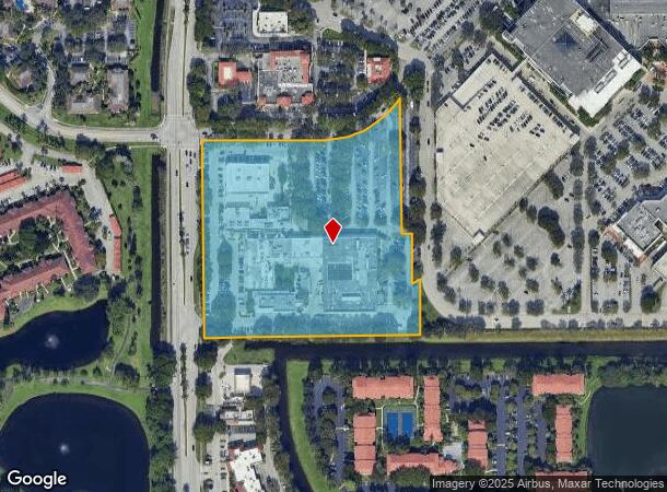
21200 Saint Andrews Blvd
06-42-47-23-00-000-3020
Acreage & Unrec
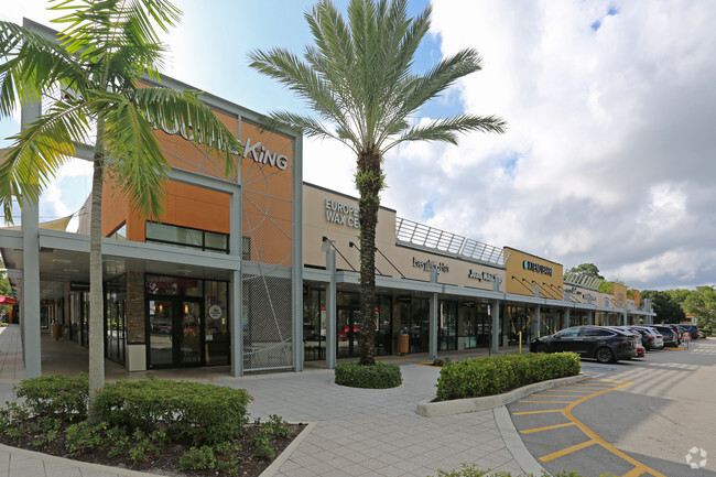
Regionalshoppingcenterormallwithanchorstore
23-47-42~ WLY 719.57 FT OF SLY648 FT OF N 1320.54 FT OF NW 1/4~ NW 1/4 LYG E OF & AS MEAS ALG ST ANDREWS BLVD
AH
Palm Beach
12099C1157F
Florida
2024
9.66 AC
2025
Boca Raton West
007622
South Florida
101,165 SF
West Palm Beach-Boca Raton-Delray Beach, FL
DEMOGRAPHICS near 21200 Saint Andrews Blvd
1 Mile
3 Mile
5 Mile
2024 Total Population
13,607
105,464
298,818
2029 Population
14,153
109,213
309,955
Pop Growth 2024-2029
+ 4.01%
+ 3.55%
+ 3.73%
Average Age
45
45
47
2024 Total Households
6,031
43,755
131,869
HH Growth 2024-2029
+ 4.13%
+ 3.50%
+ 3.89%
Median Household Inc
$80,770
$77,363
$69,217
Avg Household Size
2.20
2.20
2.10
2024 Avg HH Vehicles
1.00
2.00
2.00
Median Home Value
$429,104
$440,975
$395,302
Median Year Built
1984
1983
1983
Nearby Places
Map Layers
Map Styles
 Street
 Aerial
- Restaurants
- Banks
- Shops
- Fitness
- Groceries
PUBLIC TRANSPORTATION
COMMUTER RAIL
Boca Raton (Mainline - Brightline)
DRIVE
WALK
Distance
Boca Raton (Mainline - Brightline)
9 min
4.2 mi
Boca Raton (Tri-County Commuter - South Florida Regional Transportation Authority (Tri-Rail))
DRIVE
WALK
Distance
Boca Raton (Tri-County Commuter - South Florida Regional Transportation Authority (Tri-Rail))
11 min
5.2 mi
AIRPORT
Fort Lauderdale/Hollywood International
DRIVE
WALK
Distance
Fort Lauderdale/Hollywood International
34 min
24.4 mi
Palm Beach International
DRIVE
WALK
Distance
Palm Beach International
36 min
26.9 mi
Freight Ports
Port Everglades
DRIVE
WALK
Distance
Port Everglades
33 min
23.0 mi
SALE & LEASE HISTORY
LISTING DATE
SALE/LEASE

Oct 17, 2018
For Lease
Nearby Properties
Address
Land Use
TOTAL SIZE
Lot Size
Zoning
Address
Land Use
TOTAL SIZE
Lot Size
Zoning
824,107 SF
39.08 AC
CITY CG
Address
Land Use
TOTAL SIZE
Lot Size
Zoning
2,250,267 SF
260 AC
PL
Address
Land Use
TOTAL SIZE
Lot Size
Zoning
2,361,481 SF
120.60 AC
PL
Address
Land Use
TOTAL SIZE
Lot Size
Zoning
779,243 SF
205.02 AC
PL
Address
Land Use
TOTAL SIZE
Lot Size
Zoning
491,320 SF
11.51 AC
LIRP PMD
Address
Land Use
TOTAL SIZE
Lot Size
Zoning
437,556 SF
11.50 AC
LIRP PMD
Address
Land Use
TOTAL SIZE
Lot Size
Zoning
791,490 SF
114.95 AC
R-1-A
Address
Land Use
TOTAL SIZE
Lot Size
Zoning
600,712 SF
19.01 AC
AR
Address
Land Use
TOTAL SIZE
Lot Size
Zoning
680,226 SF
42.13 AC
RM-15
Address
Land Use
TOTAL SIZE
Lot Size
Zoning
1,949,101 SF
123.29 AC
LIRP
Address
Land Use
TOTAL SIZE
Lot Size
Zoning
760,812 SF
23.60 AC
MC
Address
Land Use
TOTAL SIZE
Lot Size
Zoning
542,392 SF
27.95 AC
R-1-D
Address
Land Use
TOTAL SIZE
Lot Size
Zoning
617,920 SF
7.75 AC
R-B-1
Address
Land Use
TOTAL SIZE
Lot Size
Zoning
399,917 SF
27.20 AC
AR
Address
Land Use
TOTAL SIZE
Lot Size
Zoning
350,010 SF
8.36 AC
R-3-B
Address
Land Use
TOTAL SIZE
Lot Size
Zoning
377,672 SF
35.64 AC
PL
Address
Land Use
TOTAL SIZE
Lot Size
Zoning
388,602 SF
74.99 AC
R-1-A
Address
Land Use
TOTAL SIZE
Lot Size
Zoning
242,023 SF
15.38 AC
RS
Address
Land Use
TOTAL SIZE
Lot Size
Zoning
259,054 SF
14.95 AC
POI
Address
Land Use
TOTAL SIZE
Lot Size
Zoning
352,250 SF
9.93 AC
CITY CHO
Address
Land Use
TOTAL SIZE
Lot Size
Zoning
299,038 SF
11.78 AC
POI*
Address
Land Use
TOTAL SIZE
Lot Size
Zoning
240,047 SF
12.13 AC
RS
Address
Land Use
TOTAL SIZE
Lot Size
Zoning
272,750 SF
19.59 AC
AR
Address
Land Use
TOTAL SIZE
Lot Size
Zoning
271,199 SF
14.79 AC
AR
Address
Land Use
TOTAL SIZE
Lot Size
Zoning
533,078 SF
14.83 AC
RS
Address
Land Use
TOTAL SIZE
Lot Size
Zoning
447,948 SF
20.33 AC
RS
Address
Land Use
TOTAL SIZE
Lot Size
Zoning
194,972 SF
48.62 AC
PL
Address
Land Use
TOTAL SIZE
Lot Size
Zoning
262,714 SF
15.67 AC
AR
Address
Land Use
TOTAL SIZE
Lot Size
Zoning
214,166 SF
9.10 AC
LIRP PMD
Address
Land Use
TOTAL SIZE
Lot Size
Zoning
176,616 SF
2.53 AC
CITY CG
The World's #1 Commercial Real Estate Marketplace
Connect with us
© 2025 CoStar Group
The information above has been obtained from sources believed reliable. While we do not doubt its accuracy we have not verified it and make no guarantee, warranty or representation about it. It is your responsibility to independently confirm its accuracy and completeness. Any projections, opinions, assumptions, or estimates used are for example only and do not represent the current or future performance of the property. The value of this transaction to you depends on tax and other factors which should be evaluated by your tax, financial, and legal advisors. You and your advisors should conduct a careful, independent investigation of the property to determine to your satisfaction the suitability of the property for your needs.