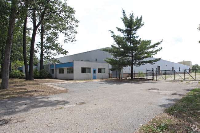
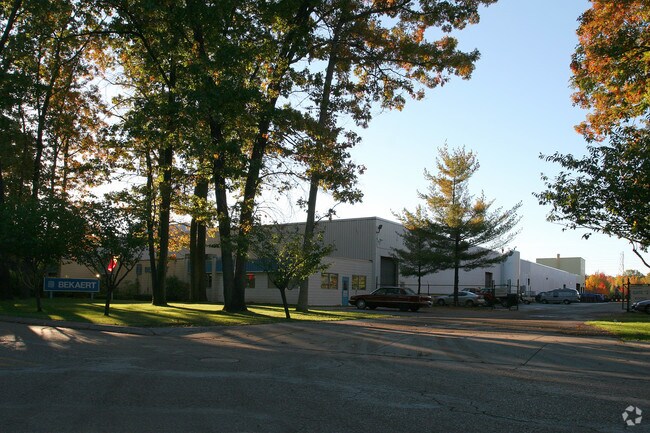
Property Record
2121 Latimer Dr, Muskegon, MI 49442
NEARBY LISTINGS FOR SALE OR LEASE
Property Detail
2121 Latimer Dr
61-24-980-212-0404-00
CITY OF MUSKEGON PORT CITY INDUSTRIAL CENTER NO 3 LOT 35
Industrialgeneral
Muskegon
X
Michigan
26121C0279E
35
2024
Eastern Muskegon County
2025
West Michigan
000402
Muskegon, MI
58,757 SF
DEMOGRAPHICS near 2121 Latimer Dr
1 Mile
3 Mile
5 Mile
2024 Total Population
2,055
52,803
95,125
2029 Population
2,059
53,248
95,935
Pop Growth 2024-2029
+ 0.19%
+ 0.84%
+ 0.85%
Average Age
41
39
39
2024 Total Households
749
19,402
37,056
HH Growth 2024-2029
+ 0.13%
+ 0.80%
+ 0.84%
Median Household Inc
$55,483
$41,846
$46,191
Avg Household Size
2.40
2.40
2.40
2024 Avg HH Vehicles
2.00
2.00
2.00
Median Home Value
$124,760
$95,851
$125,256
Median Year Built
1960
1959
1961
Nearby Places
Map Layers
Map Styles
 Street
 Aerial
- Restaurants
- Banks
- Shops
- Fitness
- Groceries
Nearby Properties
Address
Land Use
TOTAL SIZE
Lot Size
Zoning
Address
Land Use
TOTAL SIZE
Lot Size
Zoning
490,693 SF
22.70 AC
Address
Land Use
TOTAL SIZE
Lot Size
Zoning
82,643 SF
5.20 AC
MC
Address
Land Use
TOTAL SIZE
Lot Size
Zoning
129,264 SF
R
Address
Land Use
TOTAL SIZE
Lot Size
Zoning
446,688 SF
29.50 AC
RM-2
Address
Land Use
TOTAL SIZE
Lot Size
Zoning
223,802 SF
22.02 AC
SC-1
Address
Land Use
TOTAL SIZE
Lot Size
Zoning
271,435 SF
13.80 AC
I-2
Address
Land Use
TOTAL SIZE
Lot Size
Zoning
80,572 SF
12.98 AC
I-1
Address
Land Use
TOTAL SIZE
Lot Size
Zoning
2,466 SF
95.29 AC
RMH
Address
Land Use
TOTAL SIZE
Lot Size
Zoning
19,171 SF
6.55 AC
MC
Address
Land Use
TOTAL SIZE
Lot Size
Zoning
71,329 SF
I-2
Address
Land Use
TOTAL SIZE
Lot Size
Zoning
2,044 SF
4.10 AC
RT
Address
Land Use
TOTAL SIZE
Lot Size
Zoning
82,895 SF
13.09 AC
SC-1
Address
Land Use
TOTAL SIZE
Lot Size
Zoning
85,577 SF
8.72 AC
PUD
Address
Land Use
TOTAL SIZE
Lot Size
Zoning
163,658 SF
14.70 AC
RM-1
Address
Land Use
TOTAL SIZE
Lot Size
Zoning
241,589 SF
14.60 AC
I-2
Address
Land Use
TOTAL SIZE
Lot Size
Zoning
180,144 SF
3.29 AC
RM-1
Address
Land Use
TOTAL SIZE
Lot Size
Zoning
121,466 SF
11.65 AC
SC-1
Address
Land Use
TOTAL SIZE
Lot Size
Zoning
143,193 SF
13.82 AC
SC-1
Address
Land Use
TOTAL SIZE
Lot Size
Zoning
122.75 AC
R-2
Address
Land Use
TOTAL SIZE
Lot Size
Zoning
60,658 SF
4.42 AC
RM-2
Address
Land Use
TOTAL SIZE
Lot Size
Zoning
80,572 SF
12.98 AC
I-1
Address
Land Use
TOTAL SIZE
Lot Size
Zoning
17,461 SF
2.72 AC
MC
Address
Land Use
TOTAL SIZE
Lot Size
Zoning
179,172 SF
20.72 AC
I-2
Address
Land Use
TOTAL SIZE
Lot Size
Zoning
378,727 SF
44.76 AC
B-2
Address
Land Use
TOTAL SIZE
Lot Size
Zoning
118,555 SF
12.11 AC
R3
Address
Land Use
TOTAL SIZE
Lot Size
Zoning
162,949 SF
7.36 AC
I-2
Address
Land Use
TOTAL SIZE
Lot Size
Zoning
15,303 SF
1.84 AC
MC
Address
Land Use
TOTAL SIZE
Lot Size
Zoning
15,409 SF
2.51 AC
MC
Address
Land Use
TOTAL SIZE
Lot Size
Zoning
85,440 SF
4.51 AC
SUD
Address
Land Use
TOTAL SIZE
Lot Size
Zoning
31,602 SF
5.86 AC
I-2
The World's #1 Commercial Real Estate Marketplace
Connect with us
© 2025 CoStar Group
The information above has been obtained from sources believed reliable. While we do not doubt its accuracy we have not verified it and make no guarantee, warranty or representation about it. It is your responsibility to independently confirm its accuracy and completeness. Any projections, opinions, assumptions, or estimates used are for example only and do not represent the current or future performance of the property. The value of this transaction to you depends on tax and other factors which should be evaluated by your tax, financial, and legal advisors. You and your advisors should conduct a careful, independent investigation of the property to determine to your satisfaction the suitability of the property for your needs.