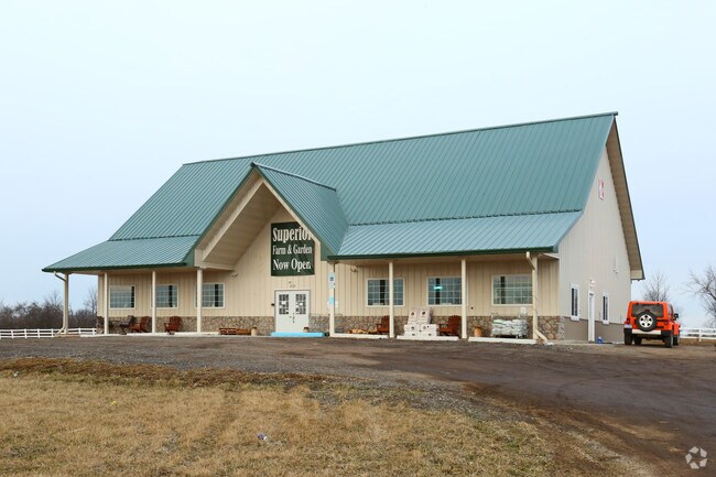
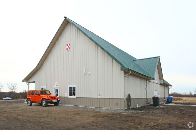
Property Record
2121 N Prospect Rd, Ypsilanti, MI 48198

NEARBY LISTINGS FOR SALE OR LEASE
Property Detail
2121 N Prospect Rd
10-28-400-013
OWNER REQUEST SU 28-10A-1B-2D PCL 3 COM AT SE COR SEC 28
Agriculturalland
Washtenaw
X
Michigan
26161C0288E
29.03 AC
2025
Washtenaw E of 23
2025
Detroit
407000
Ann Arbor, MI
4,000 SF
DEMOGRAPHICS near 2121 N Prospect Rd
1 Mile
3 Mile
5 Mile
2024 Total Population
2,439
37,834
110,312
2029 Population
2,412
37,529
108,988
Pop Growth 2024-2029
(1.11%)
(0.81%)
(1.20%)
Average Age
40
36
38
2024 Total Households
883
15,659
46,000
HH Growth 2024-2029
(1.25%)
(0.91%)
(1.31%)
Median Household Inc
$114,642
$50,855
$60,179
Avg Household Size
2.60
2.20
2.20
2024 Avg HH Vehicles
2.00
2.00
2.00
Median Home Value
$263,278
$173,566
$246,201
Median Year Built
1996
1968
1976
Nearby Places
Map Layers
Map Styles
 Street
 Aerial
- Restaurants
- Banks
- Shops
- Fitness
- Groceries
PUBLIC TRANSPORTATION
COMMUTER RAIL
Ann Arbor Amtrak Station (Wolverine - Amtrak)
DRIVE
WALK
Distance
Ann Arbor Amtrak Station (Wolverine - Amtrak)
18 min
8.0 mi
AIRPORT
Detroit Metro Wayne County
DRIVE
WALK
Distance
Detroit Metro Wayne County
30 min
19.6 mi
Freight Ports
Port of Toledo
DRIVE
WALK
Distance
Port of Toledo
79 min
61.3 mi
SALE & LEASE HISTORY
LISTING DATE
SALE/LEASE

Sep 25, 2016
For Lease
Nearby Properties
Address
Land Use
TOTAL SIZE
Lot Size
Zoning
Address
Land Use
TOTAL SIZE
Lot Size
Zoning
169,963 SF
86.24 AC
P-M
Address
Land Use
TOTAL SIZE
Lot Size
Zoning
118,166 SF
P-M
Address
Land Use
TOTAL SIZE
Lot Size
Zoning
30.77 AC
P-C
Address
Land Use
TOTAL SIZE
Lot Size
Zoning
11,204 SF
28 AC
Address
Land Use
TOTAL SIZE
Lot Size
Zoning
27,060 SF
11.47 AC
SPLIT
Address
Land Use
TOTAL SIZE
Lot Size
Zoning
27,060 SF
5.53 AC
SPLIT
Address
Land Use
TOTAL SIZE
Lot Size
Zoning
6,192 SF
19.02 AC
BA
Address
Land Use
TOTAL SIZE
Lot Size
Zoning
26,550 SF
5.44 AC
MD
Address
Land Use
TOTAL SIZE
Lot Size
Zoning
15,877 SF
60 AC
Address
Land Use
TOTAL SIZE
Lot Size
Zoning
960 SF
15 AC
BA
Address
Land Use
TOTAL SIZE
Lot Size
Zoning
124,513 SF
3.79 AC
GC
Address
Land Use
TOTAL SIZE
Lot Size
Zoning
227,900 SF
1.97 AC
M-S
Address
Land Use
TOTAL SIZE
Lot Size
Zoning
14,937 SF
8.98 AC
SPLIT
Address
Land Use
TOTAL SIZE
Lot Size
Zoning
1,913 SF
43.08 AC
Address
Land Use
TOTAL SIZE
Lot Size
Zoning
103,997 SF
4.05 AC
SPLIT
Address
Land Use
TOTAL SIZE
Lot Size
Zoning
69,790 SF
6.35 AC
II
Address
Land Use
TOTAL SIZE
Lot Size
Zoning
1,913 SF
23.63 AC
BA
Address
Land Use
TOTAL SIZE
Lot Size
Zoning
76,719 SF
11.69 AC
HHS
Address
Land Use
TOTAL SIZE
Lot Size
Zoning
87,330 SF
0.75 AC
M-S
Address
Land Use
TOTAL SIZE
Lot Size
Zoning
3.87 AC
R-4
Address
Land Use
TOTAL SIZE
Lot Size
Zoning
177,366 SF
19.88 AC
II
Address
Land Use
TOTAL SIZE
Lot Size
Zoning
59,484 SF
4.06 AC
R-4
Address
Land Use
TOTAL SIZE
Lot Size
Zoning
71,891 SF
2.20 AC
GC
Address
Land Use
TOTAL SIZE
Lot Size
Zoning
31,344 SF
5.03 AC
SPLIT
Address
Land Use
TOTAL SIZE
Lot Size
Zoning
21,538 SF
3.85 AC
M-S
Address
Land Use
TOTAL SIZE
Lot Size
Zoning
24,504 SF
6.73 AC
Address
Land Use
TOTAL SIZE
Lot Size
Zoning
19,528 SF
8.54 AC
BA
Address
Land Use
TOTAL SIZE
Lot Size
Zoning
13.86 AC
II
Address
Land Use
TOTAL SIZE
Lot Size
Zoning
55,549 SF
18.25 AC
P-C
Address
Land Use
TOTAL SIZE
Lot Size
Zoning
55,694 SF
12.44 AC
PSP
The World's #1 Commercial Real Estate Marketplace
Connect with us
© 2025 CoStar Group
The information above has been obtained from sources believed reliable. While we do not doubt its accuracy we have not verified it and make no guarantee, warranty or representation about it. It is your responsibility to independently confirm its accuracy and completeness. Any projections, opinions, assumptions, or estimates used are for example only and do not represent the current or future performance of the property. The value of this transaction to you depends on tax and other factors which should be evaluated by your tax, financial, and legal advisors. You and your advisors should conduct a careful, independent investigation of the property to determine to your satisfaction the suitability of the property for your needs.