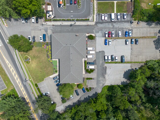
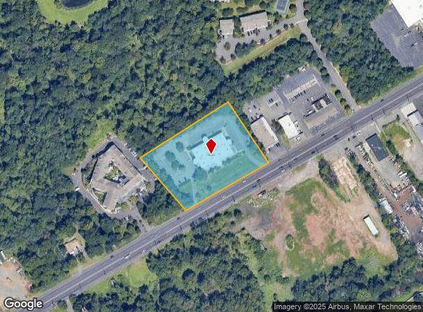
Property Record
2121 Route 22, Bound Brook, NJ 08805
This Property Is For Sale
NEARBY LISTINGS FOR SALE OR LEASE
Property Detail
2121 Route 22
06-00821-0000-00024-02
Somerset
Vacantlandnec
New Jersey
X
24.2
34023C0009F
2.96 AC
2024
Route 78 East
2025
Northern New Jersey
050703
Newark, NJ-PA
DEMOGRAPHICS near 2121 Route 22
1 Mile
3 Mile
5 Mile
2024 Total Population
8,674
68,706
183,748
2029 Population
8,603
67,949
182,720
Pop Growth 2024-2029
(0.82%)
(1.10%)
(0.56%)
Average Age
43
41
40
2024 Total Households
3,161
24,236
63,374
HH Growth 2024-2029
(0.85%)
(1.14%)
(0.52%)
Median Household Inc
$114,854
$107,948
$105,797
Avg Household Size
2.70
2.80
2.80
2024 Avg HH Vehicles
2.00
2.00
2.00
Median Home Value
$406,265
$388,474
$390,358
Median Year Built
1964
1966
1967
Nearby Places
- Restaurants
- Banks
- Shops
- Fitness
- Groceries
PUBLIC TRANSPORTATION
COMMUTER RAIL
Bound Brook (Raritan Valley Line - NJ Transit Commuter Rail (NJ Transit))
DRIVE
WALK
Distance
Bound Brook (Raritan Valley Line - NJ Transit Commuter Rail (NJ Transit))
5 min
2.4 mi
Bridgewater (Raritan Valley Line - NJ Transit Commuter Rail (NJ Transit))
DRIVE
WALK
Distance
Bridgewater (Raritan Valley Line - NJ Transit Commuter Rail (NJ Transit))
8 min
3.4 mi
AIRPORT
Newark Liberty International
DRIVE
WALK
Distance
Newark Liberty International
38 min
27.2 mi
Trenton Mercer
DRIVE
WALK
Distance
Trenton Mercer
58 min
37.2 mi
Freight Ports
New York Container Terminal
DRIVE
WALK
Distance
New York Container Terminal
41 min
30.0 mi
Nearby Properties
Address
Land Use
TOTAL SIZE
Lot Size
Zoning
Address
Land Use
TOTAL SIZE
Lot Size
Zoning
31.49 AC
LI5
Address
Land Use
TOTAL SIZE
Lot Size
Zoning
41.40 AC
LI5
Address
Land Use
TOTAL SIZE
Lot Size
Zoning
64.99 AC
LI5
Address
Land Use
TOTAL SIZE
Lot Size
Zoning
27.51 AC
RM
Address
Land Use
TOTAL SIZE
Lot Size
Zoning
22.75 AC
LC
Address
Land Use
TOTAL SIZE
Lot Size
Zoning
21.60 AC
LI5
Address
Land Use
TOTAL SIZE
Lot Size
Zoning
Address
Land Use
TOTAL SIZE
Lot Size
Zoning
24.34 AC
IND
Address
Land Use
TOTAL SIZE
Lot Size
Zoning
230,022 SF
15.48 AC
LI5
Address
Land Use
TOTAL SIZE
Lot Size
Zoning
4.05 AC
Address
Land Use
TOTAL SIZE
Lot Size
Zoning
13.38 AC
B2
Address
Land Use
TOTAL SIZE
Lot Size
Zoning
275,431 SF
17.91 AC
LI5
Address
Land Use
TOTAL SIZE
Lot Size
Zoning
19.90 AC
IND
Address
Land Use
TOTAL SIZE
Lot Size
Zoning
30.43 AC
HEC
Address
Land Use
TOTAL SIZE
Lot Size
Zoning
18.31 AC
LI5
Address
Land Use
TOTAL SIZE
Lot Size
Zoning
Address
Land Use
TOTAL SIZE
Lot Size
Zoning
10.95 AC
LC
Address
Land Use
TOTAL SIZE
Lot Size
Zoning
96,102 SF
23.60 AC
ER
Address
Land Use
TOTAL SIZE
Lot Size
Zoning
12.57 AC
Address
Land Use
TOTAL SIZE
Lot Size
Zoning
167,861 SF
9.75 AC
LI5
Address
Land Use
TOTAL SIZE
Lot Size
Zoning
15 AC
R75
Address
Land Use
TOTAL SIZE
Lot Size
Zoning
14.24 AC
RM
Address
Land Use
TOTAL SIZE
Lot Size
Zoning
17.69 AC
PRCP
Address
Land Use
TOTAL SIZE
Lot Size
Zoning
966 SF
12 AC
R-4
Address
Land Use
TOTAL SIZE
Lot Size
Zoning
0.64 AC
B2
Address
Land Use
TOTAL SIZE
Lot Size
Zoning
27 AC
MD
Address
Land Use
TOTAL SIZE
Lot Size
Zoning
17.30 AC
LI5
Address
Land Use
TOTAL SIZE
Lot Size
Zoning
19.71 AC
PRCP
Address
Land Use
TOTAL SIZE
Lot Size
Zoning
30.98 AC
C3
Address
Land Use
TOTAL SIZE
Lot Size
Zoning
126,000 SF
7.83 AC
LI5
The World's #1 Commercial Real Estate Marketplace
Connect with us
© 2025 CoStar Group
The information above has been obtained from sources believed reliable. While we do not doubt its accuracy we have not verified it and make no guarantee, warranty or representation about it. It is your responsibility to independently confirm its accuracy and completeness. Any projections, opinions, assumptions, or estimates used are for example only and do not represent the current or future performance of the property. The value of this transaction to you depends on tax and other factors which should be evaluated by your tax, financial, and legal advisors. You and your advisors should conduct a careful, independent investigation of the property to determine to your satisfaction the suitability of the property for your needs.