Property Record
2121 Waynoka Rd, Colorado Springs, CO 80915

NEARBY LISTINGS FOR SALE OR LEASE
Property Detail
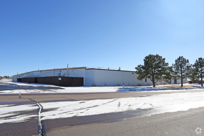
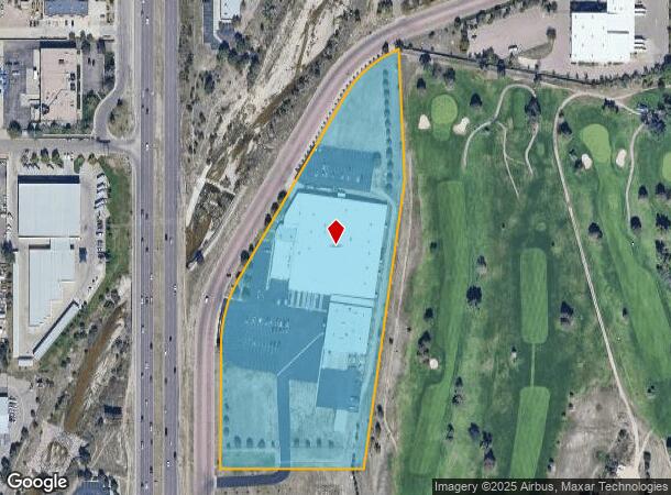
2121 Waynoka Rd
Colorado Springs, CO
Waynoka Road Industrial
54062-05-001
LOT 1 BLK 1 WAYNOKA ROAD INDUSTRIAL
Industrialgeneral
El Paso
X
Colorado
08041C0752G
1
2024
8.92 AC
2025
Southeast
005000
Colorado Springs
92,946 SF
DEMOGRAPHICS near 2121 Waynoka Rd
1 Mile
3 Mile
5 Mile
2024 Total Population
9,440
104,645
247,493
2029 Population
9,827
109,137
258,102
Pop Growth 2024-2029
+ 4.10%
+ 4.29%
+ 4.29%
Average Age
39
37
37
2024 Total Households
3,624
41,043
97,088
HH Growth 2024-2029
+ 4.50%
+ 4.55%
+ 4.55%
Median Household Inc
$72,935
$69,018
$69,095
Avg Household Size
2.50
2.50
2.50
2024 Avg HH Vehicles
2.00
2.00
2.00
Median Home Value
$343,282
$333,388
$341,149
Median Year Built
1983
1983
1984
Nearby Places
- Restaurants
- Banks
- Shops
- Fitness
- Groceries
PUBLIC TRANSPORTATION
AIRPORT
City of Colorado Springs Municipal
DRIVE
WALK
Distance
City of Colorado Springs Municipal
12 min
5.3 mi
Nearby Properties
Address
Land Use
TOTAL SIZE
Lot Size
Zoning
Address
Land Use
TOTAL SIZE
Lot Size
Zoning
8,806 SF
124.24 AC
PZ
Address
Land Use
TOTAL SIZE
Lot Size
Zoning
229,081 SF
9.87 AC
MX-N CU SS
Address
Land Use
TOTAL SIZE
Lot Size
Zoning
126,860 SF
23.92 AC
MX-N/CR AO
Address
Land Use
TOTAL SIZE
Lot Size
Zoning
167,120 SF
10.59 AC
MX-L/CR CU
Address
Land Use
TOTAL SIZE
Lot Size
Zoning
197,578 SF
7.98 AC
PDZ
Address
Land Use
TOTAL SIZE
Lot Size
Zoning
126,756 SF
12.67 AC
PUD CAD-O
Address
Land Use
TOTAL SIZE
Lot Size
Zoning
109,808 SF
8.11 AC
MX-M
Address
Land Use
TOTAL SIZE
Lot Size
Zoning
131,545 SF
12.46 AC
R-5/CR CU
Address
Land Use
TOTAL SIZE
Lot Size
Zoning
138,773 SF
4.45 AC
R-5
Address
Land Use
TOTAL SIZE
Lot Size
Zoning
87,577 SF
14.24 AC
CS CAD-O
Address
Land Use
TOTAL SIZE
Lot Size
Zoning
83,441 SF
4.20 AC
MX-M/CR CU
Address
Land Use
TOTAL SIZE
Lot Size
Zoning
8,096 SF
123.01 AC
PF APZ2 AO
Address
Land Use
TOTAL SIZE
Lot Size
Zoning
86,290 SF
8.01 AC
I-2 CAD-O
Address
Land Use
TOTAL SIZE
Lot Size
Zoning
75,169 SF
122.93 AC
I-3 CAD-O
Address
Land Use
TOTAL SIZE
Lot Size
Zoning
45,044 SF
2 AC
R-1 6
Address
Land Use
TOTAL SIZE
Lot Size
Zoning
48,117 SF
2.96 AC
MX-M CU
Address
Land Use
TOTAL SIZE
Lot Size
Zoning
104,162 SF
20.14 AC
R-1 6
Address
Land Use
TOTAL SIZE
Lot Size
Zoning
92,568 SF
11.08 AC
MX-M/CR
Address
Land Use
TOTAL SIZE
Lot Size
Zoning
35,806 SF
4.41 AC
MX-M CU AO
Address
Land Use
TOTAL SIZE
Lot Size
Zoning
45,328 SF
3.87 AC
R-4 CAD-O
Address
Land Use
TOTAL SIZE
Lot Size
Zoning
32,987 SF
6.55 AC
R-5/CR AO
Address
Land Use
TOTAL SIZE
Lot Size
Zoning
62,127 SF
6.39 AC
MX-M/CR
Address
Land Use
TOTAL SIZE
Lot Size
Zoning
185,508 SF
16.48 AC
BP/CR AO S
Address
Land Use
TOTAL SIZE
Lot Size
Zoning
45,579 SF
4.50 AC
MX-M AO
Address
Land Use
TOTAL SIZE
Lot Size
Zoning
18,277 SF
5.80 AC
MX-M AO
Address
Land Use
TOTAL SIZE
Lot Size
Zoning
52,145 SF
4.09 AC
R-1 6 CU
Address
Land Use
TOTAL SIZE
Lot Size
Zoning
190,162 SF
15.06 AC
MX-M P AO
Address
Land Use
TOTAL SIZE
Lot Size
Zoning
109,042 SF
15.56 AC
UNK
Address
Land Use
TOTAL SIZE
Lot Size
Zoning
31,201 SF
5.08 AC
PF AO
Address
Land Use
TOTAL SIZE
Lot Size
Zoning
210,964 SF
27.40 AC
BP APZ1 AO
The World's #1 Commercial Real Estate Marketplace
Connect with us
© 2025 CoStar Group
The information above has been obtained from sources believed reliable. While we do not doubt its accuracy we have not verified it and make no guarantee, warranty or representation about it. It is your responsibility to independently confirm its accuracy and completeness. Any projections, opinions, assumptions, or estimates used are for example only and do not represent the current or future performance of the property. The value of this transaction to you depends on tax and other factors which should be evaluated by your tax, financial, and legal advisors. You and your advisors should conduct a careful, independent investigation of the property to determine to your satisfaction the suitability of the property for your needs.