Property Record
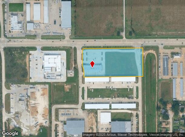
21211 Fm 529 Rd, Cypress, TX 77433
NEARBY LISTINGS FOR SALE OR LEASE
Property Detail
21211 Fm 529 Rd
1387150010001
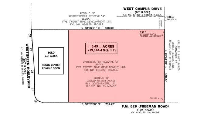
West 529 Retail Park
Stripcommercialcenter
RES A BLK 1 WEST 529 RETAIL PARK
X
Harris
48201C0415N
Texas
2024
4.88 AC
2025
Katy/Grand Parkway West
542203
Houston
13,820 SF
Houston-The Woodlands-Sugar Land, TX
DEMOGRAPHICS near 21211 Fm 529 Rd
1 Mile
3 Mile
5 Mile
2024 Total Population
9,662
99,773
271,132
2029 Population
9,855
102,586
279,066
Pop Growth 2024-2029
+ 2.00%
+ 2.82%
+ 2.93%
Average Age
34
33
34
2024 Total Households
2,807
28,698
80,954
HH Growth 2024-2029
+ 2.00%
+ 2.79%
+ 2.84%
Median Household Inc
$94,161
$88,034
$94,137
Avg Household Size
3.40
3.40
3.30
2024 Avg HH Vehicles
2.00
2.00
2.00
Median Home Value
$214,486
$225,777
$243,431
Median Year Built
2005
2008
2007
Nearby Places
Map Layers
Map Styles
 Street
 Aerial
- Restaurants
- Banks
- Shops
- Fitness
- Groceries
PUBLIC TRANSPORTATION
AIRPORT
George Bush Intcntl/Houston
DRIVE
WALK
Distance
George Bush Intcntl/Houston
43 min
29.7 mi
Freight Ports
Port of Houston
DRIVE
WALK
Distance
Port of Houston
53 min
35.9 mi
SALE & LEASE HISTORY
LISTING DATE
SALE/LEASE

Dec 22, 2016
For Sale
Apr 03, 2020
For Lease
Nearby Properties
Address
Land Use
TOTAL SIZE
Lot Size
Zoning
Address
Land Use
TOTAL SIZE
Lot Size
Zoning
851,991 SF
229.30 AC
Address
Land Use
TOTAL SIZE
Lot Size
Zoning
838,700 SF
36.68 AC
Address
Land Use
TOTAL SIZE
Lot Size
Zoning
355,721 SF
13 AC
Address
Land Use
TOTAL SIZE
Lot Size
Zoning
351,997 SF
13.28 AC
Address
Land Use
TOTAL SIZE
Lot Size
Zoning
323,609 SF
12.71 AC
Address
Land Use
TOTAL SIZE
Lot Size
Zoning
331,263 SF
11.36 AC
Address
Land Use
TOTAL SIZE
Lot Size
Zoning
236,406 SF
11.40 AC
Address
Land Use
TOTAL SIZE
Lot Size
Zoning
262,174 SF
11.64 AC
Address
Land Use
TOTAL SIZE
Lot Size
Zoning
267,766 SF
12.96 AC
Address
Land Use
TOTAL SIZE
Lot Size
Zoning
290,927 SF
14.53 AC
Address
Land Use
TOTAL SIZE
Lot Size
Zoning
279,000 SF
4.30 AC
Address
Land Use
TOTAL SIZE
Lot Size
Zoning
147,923 SF
11.60 AC
Address
Land Use
TOTAL SIZE
Lot Size
Zoning
262,048 SF
7 AC
Address
Land Use
TOTAL SIZE
Lot Size
Zoning
117,860 SF
12.44 AC
Address
Land Use
TOTAL SIZE
Lot Size
Zoning
228,152 SF
22.61 AC
Address
Land Use
TOTAL SIZE
Lot Size
Zoning
191,575 SF
17.98 AC
Address
Land Use
TOTAL SIZE
Lot Size
Zoning
122,880 SF
15 AC
Address
Land Use
TOTAL SIZE
Lot Size
Zoning
99,096 SF
27.51 AC
Address
Land Use
TOTAL SIZE
Lot Size
Zoning
201,809 SF
21.18 AC
Address
Land Use
TOTAL SIZE
Lot Size
Zoning
67,250 SF
7.37 AC
Address
Land Use
TOTAL SIZE
Lot Size
Zoning
2,939 SF
330.19 AC
Address
Land Use
TOTAL SIZE
Lot Size
Zoning
46,225 SF
6.74 AC
Address
Land Use
TOTAL SIZE
Lot Size
Zoning
84.23 AC
Address
Land Use
TOTAL SIZE
Lot Size
Zoning
52,035 SF
9.23 AC
Address
Land Use
TOTAL SIZE
Lot Size
Zoning
57,453 SF
6.74 AC
Address
Land Use
TOTAL SIZE
Lot Size
Zoning
105,500 SF
5.49 AC
Address
Land Use
TOTAL SIZE
Lot Size
Zoning
121,560 SF
12.22 AC
Address
Land Use
TOTAL SIZE
Lot Size
Zoning
156.37 AC
Address
Land Use
TOTAL SIZE
Lot Size
Zoning
67,312 SF
6.95 AC
Address
Land Use
TOTAL SIZE
Lot Size
Zoning
11,431 SF
4.60 AC
The World's #1 Commercial Real Estate Marketplace
Connect with us
© 2026 CoStar Group
The information above has been obtained from sources believed reliable. While we do not doubt its accuracy we have not verified it and make no guarantee, warranty or representation about it. It is your responsibility to independently confirm its accuracy and completeness. Any projections, opinions, assumptions, or estimates used are for example only and do not represent the current or future performance of the property. The value of this transaction to you depends on tax and other factors which should be evaluated by your tax, financial, and legal advisors. You and your advisors should conduct a careful, independent investigation of the property to determine to your satisfaction the suitability of the property for your needs.