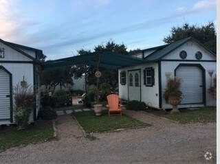
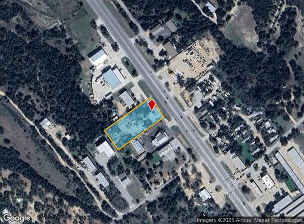
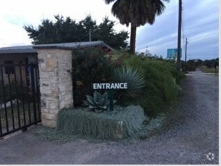
Property Record
21215 State Highway 71 W, Spicewood, TX 78669
NEARBY LISTINGS FOR SALE OR LEASE
Property Detail
21215 State Highway 71 W
Austin-Round Rock, TX
Travis Settlement Business Park
557244
LOT 6 TRAVIS SETTLEMENT BUSINESS PARK
Officebuilding
Travis
X
Texas
48453C0380J
6
2024
1.40 AC
2025
Southwest
036500
Austin
300 SF
DEMOGRAPHICS near 21215 State Highway 71 W
1 Mile
3 Mile
5 Mile
2024 Total Population
1,361
9,837
30,854
2029 Population
1,471
10,985
34,408
Pop Growth 2024-2029
+ 8.08%
+ 11.67%
+ 11.52%
Average Age
40
40
42
2024 Total Households
444
3,317
11,161
HH Growth 2024-2029
+ 8.78%
+ 12.39%
+ 12.12%
Median Household Inc
$152,917
$163,614
$153,252
Avg Household Size
3.00
2.90
2.70
2024 Avg HH Vehicles
2.00
2.00
2.00
Median Home Value
$636,160
$725,260
$691,464
Median Year Built
2007
2010
2010
Nearby Places
Map Layers
Map Styles
 Street
 Aerial
- Restaurants
- Banks
- Shops
- Fitness
- Groceries
PUBLIC TRANSPORTATION
AIRPORT
Austin-Bergstrom International
DRIVE
WALK
Distance
Austin-Bergstrom International
49 min
30.9 mi
Freight Ports
Calhoun Port
DRIVE
WALK
Distance
Calhoun Port
215 min
174.4 mi
SALE & LEASE HISTORY
LISTING DATE
SALE/LEASE

Apr 18, 2019
For Lease
Nearby Properties
Address
Land Use
TOTAL SIZE
Lot Size
Zoning
Address
Land Use
TOTAL SIZE
Lot Size
Zoning
1,159.67 AC
Address
Land Use
TOTAL SIZE
Lot Size
Zoning
668.19 AC
Address
Land Use
TOTAL SIZE
Lot Size
Zoning
4,500 SF
70 AC
Address
Land Use
TOTAL SIZE
Lot Size
Zoning
76,000 SF
6.50 AC
Address
Land Use
TOTAL SIZE
Lot Size
Zoning
2,046 SF
323.84 AC
Address
Land Use
TOTAL SIZE
Lot Size
Zoning
99,700 SF
4.40 AC
Address
Land Use
TOTAL SIZE
Lot Size
Zoning
95,624 SF
5.78 AC
Address
Land Use
TOTAL SIZE
Lot Size
Zoning
214.14 AC
Address
Land Use
TOTAL SIZE
Lot Size
Zoning
212.08 AC
Address
Land Use
TOTAL SIZE
Lot Size
Zoning
36,975 SF
4.40 AC
Address
Land Use
TOTAL SIZE
Lot Size
Zoning
2,210 SF
32.47 AC
Address
Land Use
TOTAL SIZE
Lot Size
Zoning
960 SF
170.72 AC
Address
Land Use
TOTAL SIZE
Lot Size
Zoning
13.87 AC
Address
Land Use
TOTAL SIZE
Lot Size
Zoning
35,930 SF
18.58 AC
Address
Land Use
TOTAL SIZE
Lot Size
Zoning
12,592 SF
24.61 AC
Address
Land Use
TOTAL SIZE
Lot Size
Zoning
12,693 SF
2 AC
Address
Land Use
TOTAL SIZE
Lot Size
Zoning
22,400 SF
4.11 AC
Address
Land Use
TOTAL SIZE
Lot Size
Zoning
20,400 SF
4.57 AC
Address
Land Use
TOTAL SIZE
Lot Size
Zoning
25,200 SF
10 AC
Address
Land Use
TOTAL SIZE
Lot Size
Zoning
9,100 SF
1.13 AC
Address
Land Use
TOTAL SIZE
Lot Size
Zoning
9,100 SF
1.77 AC
Address
Land Use
TOTAL SIZE
Lot Size
Zoning
11,500 SF
2.14 AC
Address
Land Use
TOTAL SIZE
Lot Size
Zoning
109.73 AC
Address
Land Use
TOTAL SIZE
Lot Size
Zoning
25,574 SF
3.54 AC
Address
Land Use
TOTAL SIZE
Lot Size
Zoning
1,064 SF
80 AC
Address
Land Use
TOTAL SIZE
Lot Size
Zoning
Address
Land Use
TOTAL SIZE
Lot Size
Zoning
21,578 SF
8.50 AC
Address
Land Use
TOTAL SIZE
Lot Size
Zoning
17,626 SF
5.35 AC
Address
Land Use
TOTAL SIZE
Lot Size
Zoning
22,333 SF
2.46 AC
Address
Land Use
TOTAL SIZE
Lot Size
Zoning
92.44 AC
The World's #1 Commercial Real Estate Marketplace
Connect with us
© 2025 CoStar Group
The information above has been obtained from sources believed reliable. While we do not doubt its accuracy we have not verified it and make no guarantee, warranty or representation about it. It is your responsibility to independently confirm its accuracy and completeness. Any projections, opinions, assumptions, or estimates used are for example only and do not represent the current or future performance of the property. The value of this transaction to you depends on tax and other factors which should be evaluated by your tax, financial, and legal advisors. You and your advisors should conduct a careful, independent investigation of the property to determine to your satisfaction the suitability of the property for your needs.