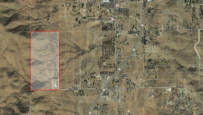
Property Record
21220 Ethanac Rd, Perris, CA 92570


NEARBY LISTINGS FOR SALE OR LEASE
Property Detail
21220 Ethanac Rd
345-020-011
80.00 ACRES IN POR SW 1/4 OF SEC 10 T5S R4W FOR TOTAL DESCRIPTION SEE ASSESSORS MAPS
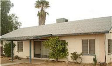
Sfr
Riverside
X
California
06065C2031G
80 AC
2024
South Riverside
2025
Inland Empire (California)
042902
Riverside-San Bernardino-Ontario, CA
1,152 SF
DEMOGRAPHICS near 21220 Ethanac Rd
1 mile
3 mile
5 mile
2024 Total Population
1,281
13,225
67,895
2029 Population
1,352
13,913
71,921
Pop Growth 2024-2029
+ 5.54%
+ 5.20%
+ 5.93%
Average Age
34
35
35
2024 Total Households
301
3,275
18,625
HH Growth 2024-2029
+ 5.65%
+ 4.89%
+ 5.61%
Median Household Inc
$28,522
$65,668
$74,761
Avg Household Size
3.90
3.80
3.50
2024 Avg HH Vehicles
3.00
3.00
2.00
Median Home Value
$233,636
$391,627
$427,381
Median Year Built
1983
1985
1991
Nearby Places
Map Layers
Map Styles
 Street
 Aerial
Transit
 Traffic
 Biking
Places
Listings with unknown addresses are not visible on the map
- Restaurants
- Banks
- Shops
- Fitness
- Groceries
PUBLIC TRANSPORTATION
COMMUTER RAIL
Perris Downtown (Metrolink 91-Perris Valley Line - Metrolink Trains)
Drive
Walk
Distance
Perris Downtown (Metrolink 91-Perris Valley Line - Metrolink Trains)
8 min
5.0 mi
South Perris (Metrolink 91-Perris Valley Line - Metrolink Trains)
Drive
Walk
Distance
South Perris (Metrolink 91-Perris Valley Line - Metrolink Trains)
11 min
6.9 mi
AIRPORT
Ontario International
Drive
Walk
Distance
Ontario International
50 min
39.0 mi
Freight Ports
Port of Long Beach
Drive
Walk
Distance
Port of Long Beach
87 min
67.9 mi
SALE & LEASE HISTORY
LISTING DATE
SALE/LEASE

Mar 01, 2018
For Sale
Jan 04, 2023
For Sale
Nearby Properties
Address
Land Use
TOTAL SIZE
Lot Size
Zoning
Address
Land Use
TOTAL SIZE
Lot Size
Zoning
198.39 AC
RR
Address
Land Use
TOTAL SIZE
Lot Size
Zoning
7,549 SF
1.97 AC
RR
Address
Land Use
TOTAL SIZE
Lot Size
Zoning
3,000 SF
3.07 AC
MSC
Address
Land Use
TOTAL SIZE
Lot Size
Zoning
720 SF
38.62 AC
W2M1
Address
Land Use
TOTAL SIZE
Lot Size
Zoning
44,323 SF
20.31 AC
Address
Land Use
TOTAL SIZE
Lot Size
Zoning
1,200 SF
C1CP
Address
Land Use
TOTAL SIZE
Lot Size
Zoning
10,133 SF
10 AC
RA10
Address
Land Use
TOTAL SIZE
Lot Size
Zoning
2,048 SF
5.55 AC
RR
Address
Land Use
TOTAL SIZE
Lot Size
Zoning
2,732 SF
12.38 AC
RR
Address
Land Use
TOTAL SIZE
Lot Size
Zoning
4,922 SF
9.52 AC
RA
Address
Land Use
TOTAL SIZE
Lot Size
Zoning
1,548 SF
13.34 AC
RA10
Address
Land Use
TOTAL SIZE
Lot Size
Zoning
720 SF
6.11 AC
RR
Address
Land Use
TOTAL SIZE
Lot Size
Zoning
5,899 SF
8.53 AC
RR
Address
Land Use
TOTAL SIZE
Lot Size
Zoning
4,586 SF
9.93 AC
RR
Address
Land Use
TOTAL SIZE
Lot Size
Zoning
1,272 SF
14.65 AC
RR
Address
Land Use
TOTAL SIZE
Lot Size
Zoning
4,910 SF
30 AC
Address
Land Use
TOTAL SIZE
Lot Size
Zoning
3,632 SF
2.82 AC
RA2
Address
Land Use
TOTAL SIZE
Lot Size
Zoning
18,702 SF
9.85 AC
RR
Address
Land Use
TOTAL SIZE
Lot Size
Zoning
4,133 SF
1.07 AC
Address
Land Use
TOTAL SIZE
Lot Size
Zoning
40 AC
RR
The World's #1 Commercial Real Estate Marketplace
Connect with us
© 2026 CoStar Group
The information above has been obtained from sources believed reliable. While we do not doubt its accuracy we have not verified it and make no guarantee, warranty or representation about it. It is your responsibility to independently confirm its accuracy and completeness. Any projections, opinions, assumptions, or estimates used are for example only and do not represent the current or future performance of the property. The value of this transaction to you depends on tax and other factors which should be evaluated by your tax, financial, and legal advisors. You and your advisors should conduct a careful, independent investigation of the property to determine to your satisfaction the suitability of the property for your needs.