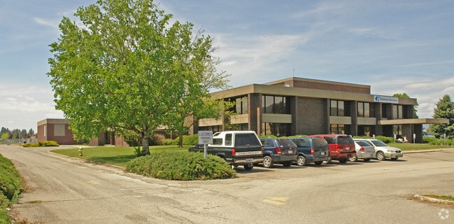
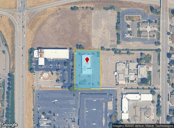
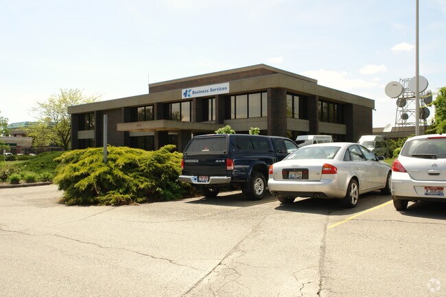
Property Record
2123 N Government Way, Coeur D Alene, ID 83814
NEARBY LISTINGS FOR SALE OR LEASE
Property Detail
2123 N Government Way
Coeur d'Alene, ID
Verizon Sub
CJ4130010020
VERIZON SUB, LT 2 BLOCK 1 CDA HEALTH CORRIDOR URD 1150N04W
Officebuilding
Kootenai
X
Idaho
16055C0410E
2
2025
2.02 AC
2025
Coeur D'Alene CBD
000902
Coeur D'Alene
28,418 SF
DEMOGRAPHICS near 2123 N Government Way
1 Mile
3 Mile
5 Mile
2024 Total Population
11,140
53,325
86,730
2029 Population
13,124
62,945
102,628
Pop Growth 2024-2029
+ 17.81%
+ 18.04%
+ 18.33%
Average Age
40
41
42
2024 Total Households
5,059
22,521
35,347
HH Growth 2024-2029
+ 17.51%
+ 17.73%
+ 18.00%
Median Household Inc
$44,209
$59,859
$64,450
Avg Household Size
2.10
2.30
2.40
2024 Avg HH Vehicles
2.00
2.00
2.00
Median Home Value
$297,956
$430,096
$447,091
Median Year Built
1979
1988
1994
Nearby Places
- Restaurants
- Banks
- Shops
- Fitness
- Groceries
PUBLIC TRANSPORTATION
AIRPORT
Spokane International
DRIVE
WALK
Distance
Spokane International
48 min
37.7 mi
Nearby Properties
Address
Land Use
TOTAL SIZE
Lot Size
Zoning
Address
Land Use
TOTAL SIZE
Lot Size
Zoning
411,826 SF
15.25 AC
Address
Land Use
TOTAL SIZE
Lot Size
Zoning
278,009 SF
34.55 AC
Address
Land Use
TOTAL SIZE
Lot Size
Zoning
169,000 SF
6.89 AC
Address
Land Use
TOTAL SIZE
Lot Size
Zoning
103,560 SF
17.30 AC
Address
Land Use
TOTAL SIZE
Lot Size
Zoning
103,531 SF
13.75 AC
COM
Address
Land Use
TOTAL SIZE
Lot Size
Zoning
32,132 SF
9.24 AC
Address
Land Use
TOTAL SIZE
Lot Size
Zoning
214,479 SF
36.82 AC
Address
Land Use
TOTAL SIZE
Lot Size
Zoning
231,330 SF
14.55 AC
Address
Land Use
TOTAL SIZE
Lot Size
Zoning
931 SF
16.15 AC
Address
Land Use
TOTAL SIZE
Lot Size
Zoning
138,614 SF
12.25 AC
Address
Land Use
TOTAL SIZE
Lot Size
Zoning
67,668 SF
3.63 AC
Address
Land Use
TOTAL SIZE
Lot Size
Zoning
230,083 SF
38.41 AC
COM
Address
Land Use
TOTAL SIZE
Lot Size
Zoning
114.08 AC
Address
Land Use
TOTAL SIZE
Lot Size
Zoning
4,569 SF
16.70 AC
Address
Land Use
TOTAL SIZE
Lot Size
Zoning
144,970 SF
11.39 AC
Address
Land Use
TOTAL SIZE
Lot Size
Zoning
4,676 SF
18.37 AC
Address
Land Use
TOTAL SIZE
Lot Size
Zoning
154,743 SF
14.27 AC
Address
Land Use
TOTAL SIZE
Lot Size
Zoning
202,072 SF
6.89 AC
Address
Land Use
TOTAL SIZE
Lot Size
Zoning
43,446 SF
4.91 AC
Address
Land Use
TOTAL SIZE
Lot Size
Zoning
104,752 SF
3.75 AC
Address
Land Use
TOTAL SIZE
Lot Size
Zoning
116,728 SF
6.48 AC
Address
Land Use
TOTAL SIZE
Lot Size
Zoning
66,856 SF
10.75 AC
Address
Land Use
TOTAL SIZE
Lot Size
Zoning
62,840 SF
8.20 AC
Address
Land Use
TOTAL SIZE
Lot Size
Zoning
167,143 SF
15.32 AC
Address
Land Use
TOTAL SIZE
Lot Size
Zoning
130,535 SF
10.58 AC
Address
Land Use
TOTAL SIZE
Lot Size
Zoning
227,906 SF
16.45 AC
Address
Land Use
TOTAL SIZE
Lot Size
Zoning
47,700 SF
32.44 AC
RESRES
Address
Land Use
TOTAL SIZE
Lot Size
Zoning
33,300 SF
85.77 AC
COM
Address
Land Use
TOTAL SIZE
Lot Size
Zoning
91,220 SF
4.66 AC
Address
Land Use
TOTAL SIZE
Lot Size
Zoning
118,990 SF
5.66 AC
The World's #1 Commercial Real Estate Marketplace
Connect with us
© 2025 CoStar Group
The information above has been obtained from sources believed reliable. While we do not doubt its accuracy we have not verified it and make no guarantee, warranty or representation about it. It is your responsibility to independently confirm its accuracy and completeness. Any projections, opinions, assumptions, or estimates used are for example only and do not represent the current or future performance of the property. The value of this transaction to you depends on tax and other factors which should be evaluated by your tax, financial, and legal advisors. You and your advisors should conduct a careful, independent investigation of the property to determine to your satisfaction the suitability of the property for your needs.