No Photo
Property Record
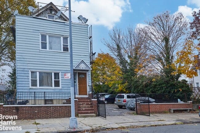
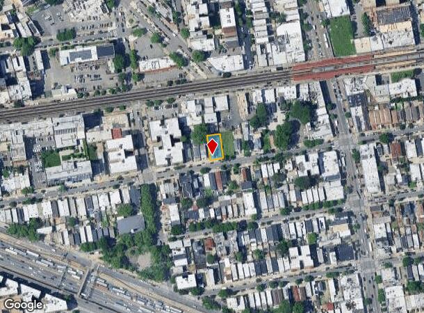
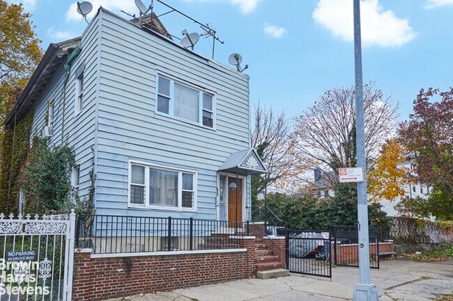
2123 Newbold Ave, Bronx, NY 10462
NEARBY LISTINGS FOR SALE OR LEASE
-
-
-
-
-
-
-
-
-
-
-
-
-
-
No Photo
-
-
View all Bronx listings for sale on LoopNet.com
Property Detail
2123 Newbold Ave
03814-0078
Bronx
Multifamilydwelling
New York
X
78
3604970103F
0.13 AC
2024
Bronx
2025
Westchester/So Connecticut
009200
New York-Jersey City-White Plains, NY-NJ
2,880 SF
DEMOGRAPHICS near 2123 Newbold Ave
1 Mile
3 Mile
5 Mile
2024 Total Population
110,519
673,586
1,769,653
2029 Population
99,117
617,574
1,635,942
Pop Growth 2024-2029
(10.32%)
(8.32%)
(7.56%)
Average Age
38
38
39
2024 Total Households
38,511
234,379
639,966
HH Growth 2024-2029
(11.02%)
(9.10%)
(8.15%)
Median Household Inc
$49,796
$43,438
$46,178
Avg Household Size
2.80
2.70
2.60
2024 Avg HH Vehicles
1.00
1.00
1.00
Median Home Value
$555,189
$569,416
$568,284
Median Year Built
1949
1954
1952
Nearby Places
Map Layers
Map Styles
 Street
 Aerial
- Restaurants
- Banks
- Shops
- Fitness
- Groceries
PUBLIC TRANSPORTATION
TRANSIT/SUBWAY
Castle Hill Avenue (6 - New York MTA Subway (The Subway))
DRIVE
WALK
Distance
Castle Hill Avenue (6 - New York MTA Subway (The Subway))
1 min
3 min
0.2 mi
Zerega Avenue (6 - New York MTA Subway (The Subway))
DRIVE
WALK
Distance
Zerega Avenue (6 - New York MTA Subway (The Subway))
2 min
10 min
0.5 mi
Parkchester (6 - New York MTA Subway (The Subway))
DRIVE
WALK
Distance
Parkchester (6 - New York MTA Subway (The Subway))
5 min
10 min
0.5 mi
Westchester Square-East Tremont Avenue (6 - New York MTA Subway (The Subway))
DRIVE
WALK
Distance
Westchester Square-East Tremont Avenue (6 - New York MTA Subway (The Subway))
2 min
16 min
0.8 mi
St Lawrence Avenue (6 - New York MTA Subway (The Subway))
DRIVE
WALK
Distance
St Lawrence Avenue (6 - New York MTA Subway (The Subway))
2 min
16 min
0.8 mi
COMMUTER RAIL
Tremont Station (Harlem Line - Metro-North Commuter Railroad Company (Metro-North))
DRIVE
WALK
Distance
Tremont Station (Harlem Line - Metro-North Commuter Railroad Company (Metro-North))
6 min
3.1 mi
Botanical Garden Station (Harlem Line - Metro-North Commuter Railroad Company (Metro-North))
DRIVE
WALK
Distance
Botanical Garden Station (Harlem Line - Metro-North Commuter Railroad Company (Metro-North))
9 min
4.2 mi
AIRPORT
LaGuardia
DRIVE
WALK
Distance
LaGuardia
18 min
8.6 mi
John F Kennedy International
DRIVE
WALK
Distance
John F Kennedy International
24 min
16.2 mi
Westchester County
DRIVE
WALK
Distance
Westchester County
35 min
22.3 mi
Freight Ports
NY - Red Hook Container Terminal
DRIVE
WALK
Distance
NY - Red Hook Container Terminal
33 min
19.1 mi
SALE & LEASE HISTORY
LISTING DATE
SALE/LEASE

Jan 15, 2020
For Sale
Aug 24, 2018
For Sale
Nearby Properties
Address
Land Use
TOTAL SIZE
Lot Size
Zoning
Address
Land Use
TOTAL SIZE
Lot Size
Zoning
550,000 SF
8.75 AC
M1-1
Address
Land Use
TOTAL SIZE
Lot Size
Zoning
1,743,584 SF
77.87 AC
R6
Address
Land Use
TOTAL SIZE
Lot Size
Zoning
1,427,393 SF
39.94 AC
R4
Address
Land Use
TOTAL SIZE
Lot Size
Zoning
481,172 SF
205.58 AC
PARK
Address
Land Use
TOTAL SIZE
Lot Size
Zoning
5,000 SF
363.58 AC
PARK
Address
Land Use
TOTAL SIZE
Lot Size
Zoning
1,012,000 SF
7.79 AC
R6
Address
Land Use
TOTAL SIZE
Lot Size
Zoning
485,484 SF
39.63 AC
R5
Address
Land Use
TOTAL SIZE
Lot Size
Zoning
667,405 SF
5.51 AC
R6
Address
Land Use
TOTAL SIZE
Lot Size
Zoning
390,750 SF
265 AC
PARK
Address
Land Use
TOTAL SIZE
Lot Size
Zoning
537,208 SF
4.73 AC
C4-3
Address
Land Use
TOTAL SIZE
Lot Size
Zoning
545,388 SF
29.07 AC
C4-3
Address
Land Use
TOTAL SIZE
Lot Size
Zoning
851,821 SF
7.95 AC
R4
Address
Land Use
TOTAL SIZE
Lot Size
Zoning
426,172 SF
14.30 AC
M3-1
Address
Land Use
TOTAL SIZE
Lot Size
Zoning
14,681 SF
97 AC
PARK
Address
Land Use
TOTAL SIZE
Lot Size
Zoning
127,000 SF
16.53 AC
M3-1
Address
Land Use
TOTAL SIZE
Lot Size
Zoning
489,326 SF
19.18 AC
C8-1
Address
Land Use
TOTAL SIZE
Lot Size
Zoning
224,037 SF
0.82 AC
C45X
Address
Land Use
TOTAL SIZE
Lot Size
Zoning
361,354 SF
C4-2
Address
Land Use
TOTAL SIZE
Lot Size
Zoning
1,172,005 SF
128.83 AC
M1-1
Address
Land Use
TOTAL SIZE
Lot Size
Zoning
510 SF
68.73 AC
PARK
Address
Land Use
TOTAL SIZE
Lot Size
Zoning
601,260 SF
3.27 AC
R4
Address
Land Use
TOTAL SIZE
Lot Size
Zoning
406,549 SF
3.22 AC
C4-4
Address
Land Use
TOTAL SIZE
Lot Size
Zoning
191,800 SF
13.39 AC
C4-3
Address
Land Use
TOTAL SIZE
Lot Size
Zoning
450,879 SF
9.10 AC
M1-1
Address
Land Use
TOTAL SIZE
Lot Size
Zoning
450,000 SF
5.59 AC
R6
Address
Land Use
TOTAL SIZE
Lot Size
Zoning
726,051 SF
33.66 AC
R5
Address
Land Use
TOTAL SIZE
Lot Size
Zoning
274,840 SF
2.80 AC
M1-1
Address
Land Use
TOTAL SIZE
Lot Size
Zoning
312,844 SF
0.44 AC
M14R7X
Address
Land Use
TOTAL SIZE
Lot Size
Zoning
674,889 SF
51.55 AC
M3-1
Address
Land Use
TOTAL SIZE
Lot Size
Zoning
140,000 SF
2.34 AC
M1-4
The World's #1 Commercial Real Estate Marketplace
Connect with us
© 2026 CoStar Group
The information above has been obtained from sources believed reliable. While we do not doubt its accuracy we have not verified it and make no guarantee, warranty or representation about it. It is your responsibility to independently confirm its accuracy and completeness. Any projections, opinions, assumptions, or estimates used are for example only and do not represent the current or future performance of the property. The value of this transaction to you depends on tax and other factors which should be evaluated by your tax, financial, and legal advisors. You and your advisors should conduct a careful, independent investigation of the property to determine to your satisfaction the suitability of the property for your needs.